| [3] |
Name on the Register[4] |
Image |
Date listed[5] |
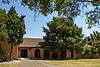
Location |
City or town |
Description |
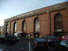
|---|
| 1 |
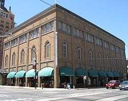
Alkali Flat Central Historic District |
|
July 26, 1984
(#84000929) |
Roughly E and F Sts. between 9th and 12th Sts.
38°35′04″N 121°29′23″W / 38.584444°N 121.489722°W / 38.584444; -121.489722 (Alkali Flat Central Historic District) |
Sacramento |
|
| 2 |
Alkali Flat North Historic District |
|
April 19, 1984
(#84000933) |
D and 11th Sts.
38°35′12″N 121°29′16″W / 38.586667°N 121.487778°W / 38.586667; -121.487778 (Alkali Flat North Historic District) |
Sacramento |
|
| 3 |
Alkali Flat West Historic District |
|
July 26, 1984
(#84000936) |
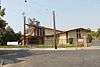
E, F, and 8th Sts.
38°35′09″N 121°29′35″W / 38.585833°N 121.493056°W / 38.585833; -121.493056 (Alkali Flat West Historic District) |
Sacramento |
|
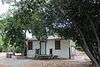
| 4 |
Alta Mesa Farm Bureau Hall |
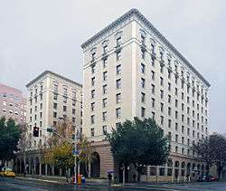
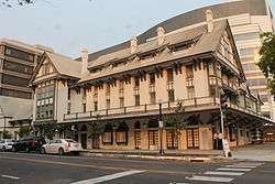
|
January 7, 1987
(#86003577) |
10195 Alta Mesa Rd.
38°23′13″N 121°13′25″W / 38.387070°N 121.223645°W / 38.387070; -121.223645 (Alta Mesa Farm Bureau Hall) |
Wilton |
The hall was destroyed by fire in 1987,[6] although the detached restroom building still stood as of June 2014. |
| 5 |
American Cash Apartments-American Cash Store |
|
March 22, 2016
(#16000094) |
1117-1123 8th St.
38°34′47″N 121°29′48″W / 38.57971°N 121.49671°W / 38.57971; -121.49671 (American Cash Apartments-American Cash Store) |
Sacramento |
|
| 6 |
American River Grange Hall No. 172 |
|
October 10, 1996
(#96001079) |
2720 Kilgore Rd.
38°36′03″N 121°16′28″W / 38.600833°N 121.274444°W / 38.600833; -121.274444 (American River Grange Hall No. 172) |
Rancho Cordova |
|
| 7 |
Blue Anchor Building |
|
February 3, 1983
(#83001224) |
1400 10th St.
38°34′33″N 121°29′42″W / 38.575833°N 121.495°W / 38.575833; -121.495 (Blue Anchor Building) |
Sacramento |
|
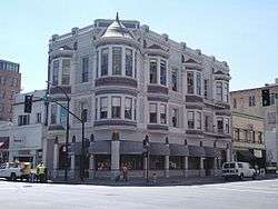
| 8 |
Boulevard Park |
|
October 6, 2011
(#11000705) |
Roughly bounded by B and H Streets, 20th Street, 22nd Street and 23rd Street
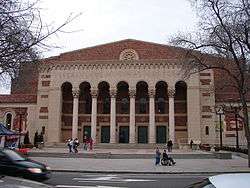
38°34′53″N 121°28′32″W / 38.581389°N 121.475556°W / 38.581389; -121.475556 (Boulevard Park) |
Sacramento |
Historic Residential Suburbs in the United States, 1830-1960 Multiple Property Submission (MPS) |
| 9 |
Brewster Building |
|
August 16, 2000
(#00000981) |
201 Fourth St.
38°15′13″N 121°21′42″W / 38.253611°N 121.361667°W / 38.253611; -121.361667 (Brewster Building) |
Galt |
|
| 10 |
Brewster House |
|
June 23, 1978
(#78000740) |
206 5th St.
38°15′12″N 121°18′14″W / 38.253333°N 121.303889°W / 38.253333; -121.303889 (Brewster House) |
Galt |
|
| 11 |
Brighton School |
|
April 3, 1981
(#81000168) |
3312 Bradshaw Rd.
38°33′44″N 121°20′09″W / 38.562222°N 121.335833°W / 38.562222; -121.335833 (Brighton School) |
Sacramento |
|
| 12 |
John Stanford Brown House |
|
July 28, 2004
(#04000733) |
13950 CA 160
38°14′53″N 121°30′41″W / 38.248056°N 121.511389°W / 38.248056; -121.511389 (John Stanford Brown House) |
Walnut Grove |
|
| 13 |
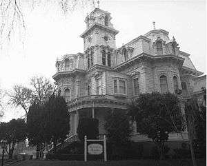
California Governor's Mansion |
|
November 10, 1970
(#70000139) |
16th and H Sts.
38°34′49″N 121°29′01″W / 38.580278°N 121.483611°W / 38.580278; -121.483611 (California Governor's Mansion) |
Sacramento |
|
| 14 |
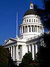
California State Capitol |
|
April 3, 1973
(#73000427) |
Between 10th and 16th and L and N Sts.
38°34′34″N 121°29′26″W / 38.576111°N 121.490556°W / 38.576111; -121.490556 (California State Capitol) |
Sacramento |
|
| 15 |
Calpak Plant No. 11 |
|
May 17, 1984
(#84000939) |
1721 C St.
38°35′09″N 121°28′49″W / 38.585830°N 121.480407°W / 38.585830; -121.480407 (Calpak Plant No. 11) |
Sacramento |
|
| 16 |
Capitol Extension District |
|
May 24, 1984
(#84000944) |
Capitol Mall
38°34′37″N 121°29′46″W / 38.576944°N 121.496111°W / 38.576944; -121.496111 (Capitol Extension District) |
Sacramento |
|
| 17 |
J.C. Carly House |
|
March 22, 2006
(#06000143) |
2761 Montgomery Way
38°32′56″N 121°28′33″W / 38.548889°N 121.475833°W / 38.548889; -121.475833 (J.C. Carly House) |
Sacramento |
|
| 18 |
Chung Wah Cemetery |
|
August 21, 1995
(#95000999) |
Mormon St. vicinity, near Lake Natoma
38°40′13″N 121°11′43″W / 38.670278°N 121.195278°W / 38.670278; -121.195278 (Chung Wah Cemetery) |
Folsom |
|
| 19 |
Cohn House |
|
January 21, 1982
(#82002228) |
305 Scott St.
38°40′43″N 121°10′26″W / 38.678611°N 121.173889°W / 38.678611; -121.173889 (Cohn House) |
Folsom |
|
| 20 |
Coolot Company Building |
|
September 20, 1978
(#78000742) |
812 J St.
38°34′51″N 121°29′41″W / 38.580833°N 121.494722°W / 38.580833; -121.494722 (Coolot Company Building) |
Sacramento |
No longer standing. Originally constructed in 1861 by Leland Stanford.[6] |
| 21 |
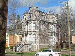
Cranston-Geary House |
|
January 23, 1998
(#97001662) |
2101 G St.
38°34′47″N 121°28′32″W / 38.579722°N 121.475556°W / 38.579722; -121.475556 (Cranston-Geary House) |
Sacramento |
|
| 22 |
E. B. Crocker Art Gallery |
|
May 6, 1971
(#71000176) |
216 O St.
38°34′37″N 121°30′18″W / 38.576944°N 121.505°W / 38.576944; -121.505 (E. B. Crocker Art Gallery) |
Sacramento |
|
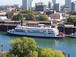
| 23 |
DELTA KING |
|
March 31, 1978
(#78000797) |
1000 Front St.
38°34′58″N 121°30′25″W / 38.582778°N 121.506944°W / 38.582778; -121.506944 (DELTA KING) |
Sacramento |
Located in Rio Vista when listed on the National Register; moved to Old Sacramento in 1984 and converted to a hotel, restaurant and theater[7] |
| 24 |
Delta Meadows Site |
|
November 5, 1971
(#71000175) |
Address Restricted
|
Locke |
|
| 25 |
Dunlap's Dining Room |
|
April 2, 1992
(#92000308) |
4322 Fourth Ave.
38°32′52″N 121°27′18″W / 38.547778°N 121.455°W / 38.547778; -121.455 (Dunlap's Dining Room) |
Sacramento |
|
| 26 |
Eastern Star Hall |
|
January 7, 1993
(#92001757) |
2719 K St.
38°34′21″N 121°28′22″W / 38.5725°N 121.472778°W / 38.5725; -121.472778 (Eastern Star Hall) |
Sacramento |
|
| 27 |
William Ehrhardt House |
|
July 10, 2003
(#03000614) |
Dartmoor Way and Percheron Dr.
38°24′11″N 121°26′54″W / 38.403056°N 121.448333°W / 38.403056; -121.448333 (William Ehrhardt House) |
Elk Grove |
|
| 28 |
Elk Grove Historic District |
|
March 1, 1988
(#87002410) |
8986-9097 Elk Grove Blvd. also School, Gage and Grove Sts.
38°24′33″N 121°21′49″W / 38.409167°N 121.363611°W / 38.409167; -121.363611 (Elk Grove Historic District) |
Elk Grove |
|
| 29 |
Fire Station No. 6 |
|
April 25, 1991
(#91000484) |
3414 4th Ave.
38°33′02″N 121°28′07″W / 38.550556°N 121.468611°W / 38.550556; -121.468611 (Fire Station No. 6) |
Sacramento |
|
| 30 |
Firehouse No. 3 |
|
October 29, 1991
(#91001537) |
1215 19th St.
38°34′28″N 121°28′52″W / 38.574444°N 121.481111°W / 38.574444; -121.481111 (Firehouse No. 3) |
Sacramento |
|
| 31 |
Folsom Depot |
|
February 19, 1982
(#82002229) |
200 Wool St.
38°40′45″N 121°10′47″W / 38.679167°N 121.179722°W / 38.679167; -121.179722 (Folsom Depot) |
Folsom |
Southern Pacific Railroad standard design Two Story Combination Depot No. 22[8] |
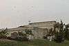
| 32 |
Folsom Powerhouse |
|
October 2, 1973
(#73000426) |
Off Folsom Blvd. in Folsom Lake State Recreation Area
38°40′50″N 121°10′32″W / 38.680556°N 121.175556°W / 38.680556; -121.175556 (Folsom Powerhouse) |
Folsom |
|
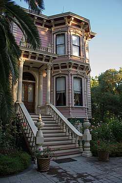
| 33 |
Mary Haley Galarneaux House |
|
February 12, 2001
(#01000077) |
922-924 T. St.
38°34′15″N 121°29′56″W / 38.570833°N 121.498889°W / 38.570833; -121.498889 (Mary Haley Galarneaux House) |
Sacramento |
|
| 34 |
Goethe House |
|
February 19, 1982
(#82002230) |
3731 T St.
38°33′33″N 121°27′34″W / 38.559167°N 121.459444°W / 38.559167; -121.459444 (Goethe House) |
Sacramento |
|
| 35 |
John T. Greene House |
|
April 15, 1982
(#82002231) |
3200 H St.
38°34′31″N 121°27′44″W / 38.575278°N 121.462222°W / 38.575278; -121.462222 (John T. Greene House) |
Sacramento |
|
| 36 |
Heilbron House |
|
December 12, 1976
(#76000511) |
704 O St.
38°34′34″N 121°29′54″W / 38.576111°N 121.498333°W / 38.576111; -121.498333 (Heilbron House) |
Sacramento |
|
| 37 |
Hotel Regis |
|
October 29, 1982
(#82000979) |
1024-1030 K St
38°34′44″N 121°29′30″W / 38.578889°N 121.491667°W / 38.578889; -121.491667 (Hotel Regis) |
Sacramento |
|
| 38 |
Hotel Senator |
|
May 30, 1979
(#79003459) |
1121 L St.
38°34′40″N 121°29′28″W / 38.577778°N 121.491111°W / 38.577778; -121.491111 (Hotel Senator) |
Sacramento |
|
| 39 |
Edward P. Howe, Jr., House |
|
February 19, 1982
(#82002232) |
2215 21st St.
38°33′46″N 121°28′59″W / 38.562778°N 121.483056°W / 38.562778; -121.483056 (Edward P. Howe, Jr., House) |
Sacramento |
|
| 40 |
Hubbard-Upson House |
|
December 2, 1977
(#77000327) |
1010 F St.
38°35′04″N 121°29′24″W / 38.584444°N 121.49°W / 38.584444; -121.49 (Hubbard-Upson House) |
Sacramento |
|
| 41 |
I Street Bridge |
|
April 22, 1982
(#82002233) |
CA 16
38°34′39″N 121°30′18″W / 38.5775°N 121.505°W / 38.5775; -121.505 (I Street Bridge) |
Sacramento |
|
| 42 |
Imperial Theatre |
|
October 29, 1982
(#82000980) |
Market St.
38°14′29″N 121°30′46″W / 38.241389°N 121.512778°W / 38.241389; -121.512778 (Imperial Theatre) |
Walnut Grove |
|
| 43 |
Indian Stone Corral |
|
April 16, 1975
(#75000456) |
Address Restricted
|
Orangevale |
|
| 44 |
Isleton Chinese and Japanese Commercial Districts |
|
March 14, 1991
(#91000297) |
Bounded by River Rd. and Union, E and H Sts.
38°09′45″N 121°36′18″W / 38.1625°N 121.605°W / 38.1625; -121.605 (Isleton Chinese and Japanese Commercial Districts) |
Isleton |
|
| 45 |
J Street Wreck |
|
May 16, 1991
(#91000562) |
At the foot of J St., in the Sacramento River
38°35′02″N 121°30′19″W / 38.583889°N 121.505278°W / 38.583889; -121.505278 (J Street Wreck) |
Sacramento |
The remains of a brig used as a warehouse off J Street which sank in 1855.[6] |
| 46 |
Joe Mound |
|
October 14, 1971
(#71000177) |
Address Restricted
|
Sacramento |
An Indian village site of the Maidu near present day Discovery Park. No marker on the site.[6] |
| 47 |
J. Neely Johnson House |
|
September 13, 1976
(#76000512) |
1029 F St.
38°35′05″N 121°29′22″W / 38.584722°N 121.489444°W / 38.584722; -121.489444 (J. Neely Johnson House) |
Sacramento |
|
| 48 |
Theodore Judah School |
|
July 25, 1997
(#97000810) |
3919 McKinley Blvd.
38°34′39″N 121°27′42″W / 38.5775°N 121.461667°W / 38.5775; -121.461667 (Theodore Judah School) |
Sacramento |
|
| 49 |
Kuchler Row |
|
June 25, 1982
(#82002234) |
608-614 10th St.
38°35′03″N 121°29′27″W / 38.584167°N 121.490833°W / 38.584167; -121.490833 (Kuchler Row) |
Sacramento |
|
| 50 |
Charles Lais House |
|
February 28, 1985
(#85000358) |
1301 H St.
38°34′54″N 121°29′13″W / 38.581667°N 121.486944°W / 38.581667; -121.486944 (Charles Lais House) |
Sacramento |
|
| 51 |
Lawrence Warehouse |
|
January 15, 2014
(#13001067) |
1108 R St.
38°34′15″N 121°29′44″W / 38.570758°N 121.495594°W / 38.570758; -121.495594 (Lawrence Warehouse) |
Sacramento |
|
| 52 |
Libby, McNeil and Libby Fruit and Vegetable Cannery |
|
March 2, 1982
(#82002235) |
1724 Stockton Blvd.
38°33′52″N 121°27′59″W / 38.564444°N 121.466389°W / 38.564444; -121.466389 (Libby, McNeil and Libby Fruit and Vegetable Cannery) |
Sacramento |
|
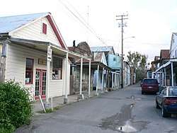
| 53 |
Locke Historic District |
|
May 6, 1971
(#71000174) |
Bounded on the W by the Sacramento River, on the N by Locke Rd., on the E by Alley St., and on the S by Levee St.
38°15′03″N 121°30′26″W / 38.250833°N 121.507222°W / 38.250833; -121.507222 (Locke Historic District) |
Locke |
|
| 54 |
Maydestone Apartments |
|
September 25, 2012
(#12000812) |
1001 15th St.
38°34′42″N 121°29′11″W / 38.578215°N 121.486443°W / 38.578215; -121.486443 (Maydestone Apartments) |
Sacramento |
|
| 55 |
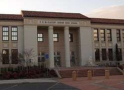
C. K. McClatchy Senior High School |
|
November 2, 2001
(#01001193) |
3066 Freeport Blvd.
38°33′04″N 121°29′33″W / 38.551111°N 121.4925°W / 38.551111; -121.4925 (C. K. McClatchy Senior High School) |
Sacramento |
|
| 56 |
Merchants National Bank of Sacramento |
|
February 16, 1996
(#96000108) |
1015 7th St.
38°34′52″N 121°29′47″W / 38.581111°N 121.496389°W / 38.581111; -121.496389 (Merchants National Bank of Sacramento) |
Sacramento |
|
| 57 |
Merrium Apartments |
|
September 13, 1990
(#90001386) |
1017 14th St.
38°34′41″N 121°29′12″W / 38.578056°N 121.486667°W / 38.578056; -121.486667 (Merrium Apartments) |
Sacramento |
Demolished in the 1990s for expansion of the Sacramento Convention Center.[6] |
| 58 |
Mesick House |
|
January 21, 1982
(#82002236) |
517 8th St.
38°35′10″N 121°29′34″W / 38.586111°N 121.492778°W / 38.586111; -121.492778 (Mesick House) |
Sacramento |
|
| 59 |
Mohr and Yoerk Market |
|
July 31, 2017
(#100001385) |
1029 K St.
38°34′45″N 121°29′34″W / 38.579116°N 121.492821°W / 38.579116; -121.492821 (Mohr and Yoerk Market) |
Sacramento |
|
| 60 |
New Helvetia Historic District |
|
April 4, 2014
(#14000109) |
752 Revere St.
38°33′47″N 121°30′17″W / 38.56294°N 121.504821°W / 38.56294; -121.504821 (New Helvetia Historic District) |
Sacramento |
|
| 61 |
Nisenan Village Site |
|
March 21, 1978
(#78000739) |
Address Restricted
|
Carmichael |
|
| 62 |
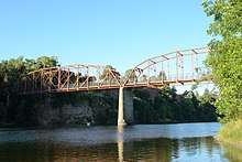
Old Fair Oaks Bridge |
|
September 25, 2006
(#06000913) |
Crosses the American River at Bridge St. to American River Pkwy, north of Upper Sunrise Dr. in Gold River
38°38′17″N 121°15′54″W / 38.638056°N 121.265°W / 38.638056; -121.265 (Old Fair Oaks Bridge) |
Fair Oaks |
|
| 63 |
Old Sacramento Historic District |
|
October 15, 1966
(#66000219) |
Junctions of U.S. 40, 50, 99, and CA 16 and 24
38°34′58″N 121°30′12″W / 38.582778°N 121.503333°W / 38.582778; -121.503333 (Old Sacramento Historic District) |
Sacramento |
|
| 64 |
Old Tavern |
|
September 15, 1983
(#83001225) |
2801 Capitol Ave.
38°34′15″N 121°28′09″W / 38.570833°N 121.469167°W / 38.570833; -121.469167 (Old Tavern) |
Sacramento |
|
| 65 |
PG&E Powerhouse |
|
September 23, 2010
(#10000774) |
400 Jibboom St.
38°35′42″N 121°30′18″W / 38.595°N 121.505°W / 38.595; -121.505 (PG&E Powerhouse) |
Sacramento |
|
| 66 |
Pony Express Terminal |
|
October 15, 1966
(#66000220) |
1006 2nd St.
38°34′59″N 121°30′11″W / 38.583056°N 121.503056°W / 38.583056; -121.503056 (Pony Express Terminal) |
Sacramento |
Also known as B. F. Hastings Bank Building |
| 67 |
Rosebud Ranch |
|
December 31, 1979
(#79000521) |
North of Hood
38°23′08″N 121°30′46″W / 38.385556°N 121.512778°W / 38.385556; -121.512778 (Rosebud Ranch) |
Hood |
|
| 68 |
Ruhstaller Building |
|
January 21, 1982
(#82002237) |
900 J St.
38°34′50″N 121°29′38″W / 38.580556°N 121.493889°W / 38.580556; -121.493889 (Ruhstaller Building) |
Sacramento |
Built in 1898, at the corner of 9th and J Street in Sacramento, California, the 20,000 square feet building was built by the behest of Frank F. Ruhstaller and housed The Ruhstaller Brewery offices. Ruhstaller also managed Buffalo Brewery and made the building its headquarters as well. |
| 69 |
Runyon House |
|
October 27, 2000
(#00001270) |
12865 River Rd.
38°17′20″N 121°33′20″W / 38.288889°N 121.555556°W / 38.288889; -121.555556 (Runyon House) |
Courtland |
|
| 70 |
Sacramento Air Depot Historic District |
|
January 21, 1992
(#91001969) |
McClellan Air Force Base
38°39′33″N 121°23′13″W / 38.659167°N 121.386944°W / 38.659167; -121.386944 (Sacramento Air Depot Historic District) |
North Highlands |
|
| 71 |
Sacramento Bank Building |
|
January 21, 1982
(#82002238) |
3418 Broadway
38°33′07″N 121°28′05″W / 38.551944°N 121.468056°W / 38.551944; -121.468056 (Sacramento Bank Building) |
Sacramento |
|
| 72 |
Sacramento City Cemetery |
|
November 5, 2014
(#14000889) |
1000 Broadway
38°33′47″N 121°30′04″W / 38.563°N 121.5010°W / 38.563; -121.5010 (Sacramento City Cemetery) |
Sacramento |
|
| 73 |
Sacramento City Library |
|
July 30, 1992
(#92000967) |
828 I St.
38°34′54″N 121°29′42″W / 38.581749°N 121.495129°W / 38.581749; -121.495129 (Sacramento City Library) |
Sacramento |
part of the California Carnegie Libraries MPS |
| 74 |
Sacramento Hall of Justice |
|
September 24, 1999
(#99001179) |
813 6th St.
38°35′01″N 121°29′06″W / 38.583611°N 121.485°W / 38.583611; -121.485 (Sacramento Hall of Justice) |
Sacramento |
|
| 75 |
Sacramento Junior College Annex and Extensions |
|
August 22, 1994
(#94000924) |
3835 Freeport Blvd.
38°32′28″N 121°29′17″W / 38.541111°N 121.488056°W / 38.541111; -121.488056 (Sacramento Junior College Annex and Extensions) |
Sacramento |
|
| 76 |
Sacramento Masonic Temple |
|
May 17, 2001
(#01000488) |
1131 J St.
38°34′55″N 121°29′27″W / 38.581944°N 121.490833°W / 38.581944; -121.490833 (Sacramento Masonic Temple) |
Sacramento |
|
| 77 |
Sacramento Memorial Auditorium |
|
March 29, 1978
(#78000743) |
16th and J Sts.
38°34′44″N 121°29′05″W / 38.578889°N 121.484722°W / 38.578889; -121.484722 (Sacramento Memorial Auditorium) |
Sacramento |
|
| 78 |
Shiloh Baptist Church |
|
July 3, 2012
(#12000376) |
3552 7th Ave.
38°32′40″N 121°28′07″W / 38.544322°N 121.468558°W / 38.544322; -121.468558 (Shiloh Baptist Church) |
Sacramento |
|
| 79 |
Slocum House |
|
January 31, 1979
(#79000520) |
7992 California Ave.
38°38′29″N 121°16′05″W / 38.641389°N 121.268056°W / 38.641389; -121.268056 (Slocum House) |
Fair Oaks |
|
| 80 |
Southern Pacific Railroad Company's Sacramento Depot |
|
April 21, 1975
(#75000457) |
5th and I Sts.
38°35′03″N 121°30′00″W / 38.584167°N 121.5°W / 38.584167; -121.5 (Southern Pacific Railroad Company's Sacramento Depot) |
Sacramento |
|
| 81 |
SMUD Headquarters Building |
|
January 4, 2010
(#09001161) |
6301 S. St.
38°33′11″N 121°25′58″W / 38.553122°N 121.432861°W / 38.553122; -121.432861 (SMUD Headquarters Building) |
Sacramento |
|
| 82 |
Southern Pacific Railroad Section Superintendent House |
|
June 13, 2008
(#08000501) |
815 Oakdale St.
38°40′11″N 121°10′55″W / 38.669639°N 121.182028°W / 38.669639; -121.182028 (Southern Pacific Railroad Section Superintendent House) |
Folsom |
|
| 83 |
Southside Park |
|
December 18, 2017
(#100001892) |
Between T, W, 6th & 8th Sts.
38°34′08″N 121°30′11″W / 38.568949°N 121.502935°W / 38.568949; -121.502935 (Southside Park) |
Sacramento |
|
| 84 |
Stanford-Lathrop House |
|
December 9, 1971
(#71000178) |
800 N St.
38°34′35″N 121°29′50″W / 38.576389°N 121.497222°W / 38.576389; -121.497222 (Stanford-Lathrop House) |
Sacramento |
A mansion once owned by Leland Stanford, Governor of California from 1862 to 1863, U.S. Senator from 1885 to 1893, railroad tycoon, member of the Big Four and founder of Stanford University. |
| 85 |
Sutter Club |
|
May 8, 2017
(#100000951) |
1220 9th St.
38°34′40″N 121°29′47″W / 38.577834°N 121.496413°W / 38.577834; -121.496413 (Sutter Club) |
Sacramento |
|
| 86 |
Sutter's Fort |
|
October 15, 1966
(#66000221) |
2701 L St.
38°34′20″N 121°28′12″W / 38.572222°N 121.47°W / 38.572222; -121.47 (Sutter's Fort) |
Sacramento |
|
| 87 |
Tower Bridge |
|
June 24, 1982
(#82004845) |
CA 275 across Sacramento River
38°34′18″N 121°30′25″W / 38.571667°N 121.506944°W / 38.571667; -121.506944 (Tower Bridge) |
Sacramento |
|
| 88 |
Travelers' Hotel |
|
October 19, 1978
(#78000744) |
428 J St.
38°34′54″N 121°29′58″W / 38.581667°N 121.499444°W / 38.581667; -121.499444 (Travelers' Hotel) |
Sacramento |
|
| 89 |
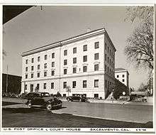
U.S. Post Office, Courthouse and Federal Building |
|
January 25, 1980
(#80000835) |
801 I St.
38°34′57″N 121°29′37″W / 38.5825°N 121.493611°W / 38.5825; -121.493611 (U.S. Post Office, Courthouse and Federal Building) |
Sacramento |
|
| 90 |
Van Voorhies House |
|
November 17, 1977
(#77000328) |
925 G St.
38°35′03″N 121°29′29″W / 38.584167°N 121.491389°W / 38.584167; -121.491389 (Van Voorhies House) |
Sacramento |
|
| 91 |
Anton Wagner Duplex |
|
November 10, 1980
(#80000836) |
701 E St.
38°35′13″N 121°29′35″W / 38.586944°N 121.493056°W / 38.586944; -121.493056 (Anton Wagner Duplex) |
Sacramento |
|
| 92 |
Walnut Grove Chinese-American Historic District |
|
March 22, 1990
(#90000484) |
Bounded by C, Tyler, and Bridge Sts., and River Rd.
38°14′32″N 121°30′46″W / 38.242222°N 121.512778°W / 38.242222; -121.512778 (Walnut Grove Chinese-American Historic District) |
Walnut Grove |
|
| 93 |
Walnut Grove Commercial/Residential Historic District |
|
April 12, 1990
(#90000551) |
Browns Alley and River Rd.
38°14′21″N 121°30′54″W / 38.239167°N 121.515°W / 38.239167; -121.515 (Walnut Grove Commercial/Residential Historic District) |
Walnut Grove |
|
| 94 |
Walnut Grove Gakuen Hall |
|
June 17, 1980
(#80000837) |
Pine and C Sts.
38°14′31″N 121°30′33″W / 38.241944°N 121.509167°W / 38.241944; -121.509167 (Walnut Grove Gakuen Hall) |
Walnut Grove |
|
| 95 |
Walnut Grove Japanese-American Historic District |
|
March 22, 1990
(#90000483) |
Bounded by Winnie St., Tyler St., C St., and River Rd.
38°14′36″N 121°30′44″W / 38.243333°N 121.512222°W / 38.243333; -121.512222 (Walnut Grove Japanese-American Historic District) |
Walnut Grove |
|
| 96 |
Westminster Presbyterian Church |
|
May 22, 2003
(#03000425) |
1300 N St.
38°34′35″N 121°29′27″W / 38.576389°N 121.490833°W / 38.576389; -121.490833 (Westminster Presbyterian Church) |
Sacramento |
|
| 97 |
Julius Wetzlar House |
|
March 31, 1983
(#83001226) |
1021 H St.
38°34′58″N 121°29′27″W / 38.582778°N 121.490833°W / 38.582778; -121.490833 (Julius Wetzlar House) |
Sacramento |
|
| 98 |
Winters House |
|
January 25, 1999
(#98001634) |
2324 and 2326 H St.
38°34′39″N 121°28′23″W / 38.5775°N 121.473056°W / 38.5775; -121.473056 (Winters House) |
Sacramento |
|
| 99 |
Edwin Witter Ranch |
|
March 14, 1991
(#91000284) |
3480 Witter Way
38°37′54″N 121°32′05″W / 38.631667°N 121.534722°W / 38.631667; -121.534722 (Edwin Witter Ranch) |
Sacramento |
|
| 100 |
Woodlake Site |
|
May 6, 1971
(#71000179) |
Address Restricted
|
Sacramento |
|

_-_HDR.JPG)
.jpg)
.JPG)
.JPG)
%2C_Sacramento%2C_CA_-_DSC03854.JPG)
.jpg)
.JPG)
.JPG)
.jpg)

.jpg)
.jpg)