| [3] |
Name on the Register[4] |
Image |
Date listed[5] |
Location |
City or town |
Description |
|---|
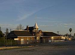
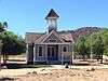
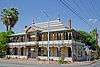
| 1 |
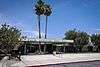
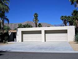
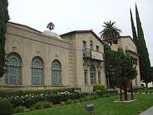
Administration Building, Sherman Institute |
|
January 9, 1980
(#80000831) |
9010 Magnolia Ave.
33°55′30″N 117°26′13″W / 33.925°N 117.436944°W / 33.925; -117.436944 (Administration Building, Sherman Institute) |
Riverside |
|
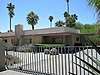
| 2 |
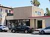
Dr. Franz Alexander House |
|
March 22, 2016
(#16000093) |
1011 W. Cielo Dr.
33°50′44″N 116°33′35″W / 33.845456°N 116.559596°W / 33.845456; -116.559596 (Dr. Franz Alexander House) |
Palm Springs |
|
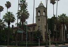
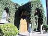
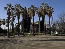
| 3 |
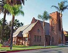
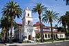
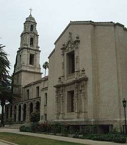
All Souls Universalist Church |
|
September 18, 1978
(#78000736) |
3657 Lemon St.
33°58′56″N 117°22′14″W / 33.982222°N 117.370556°W / 33.982222; -117.370556 (All Souls Universalist Church) |
Riverside |
|
| 4 |
Andreas Canyon |
|
January 8, 1973
(#73000422) |
Address Restricted
|
Palm Springs |
|
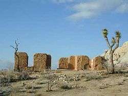
| 5 |
Archeological Sites CA-RIV-504 and CA-RIV-773 |
|
March 12, 2003
(#03000121) |
Address Restricted
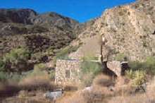
|
Blythe |
|
| 6 |
Arlington Branch Library and Fire Hall |
|
July 22, 1993
(#93000668) |
9556 Magnolia Ave.
33°55′11″N 117°26′48″W / 33.919722°N 117.446667°W / 33.919722; -117.446667 (Arlington Branch Library and Fire Hall) |
Riverside |
|
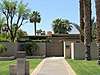
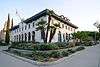
| 7 |
Armory Hall |
|
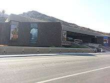
January 29, 1992
(#91002032) |
252 N. Main St.
33°40′15″N 117°19′32″W / 33.670833°N 117.325556°W / 33.670833; -117.325556 (Armory Hall) |
Lake Elsinore |
|
| 8 |
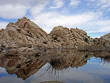
Barker Dam |
|
October 29, 1975
(#75000173) |
SE of Twentynine Palms in Joshua Tree National Park
34°01′52″N 116°08′39″W / 34.031111°N 116.144167°W / 34.031111; -116.144167 (Barker Dam) |
Twentynine Palms |
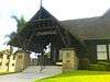
|
| 9 |
Miles C. Bates House |
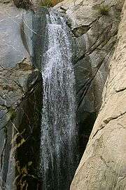
|
March 26, 2018
(#100002238) |
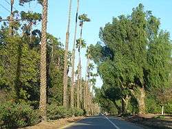
73697 Santa Rosa Way
33°43′40″N 116°22′45″W / 33.727793°N 116.379133°W / 33.727793; -116.379133 (Miles C. Bates House) |
Palm Desert |
|
| 10 |
Blythe Intaglios |
|
August 22, 1975
(#75000452) |
Address Restricted
|
Blythe |
|
| 11 |
Buttercup Farms Pictograph |
|
May 3, 1976
(#76000509) |
Address Restricted
|
Perris |
|
| 12 |
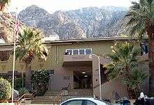
Cabot's Old Indian Pueblo Museum |
|
March 2, 2012
(#11000942) |
67-616 E. Desert View Ave.
33°57′29″N 116°28′56″W / 33.958069°N 116.482234°W / 33.958069; -116.482234 (Cabot's Old Indian Pueblo Museum) |
Desert Hot Springs |
|
| 13 |
Carey House |
|
September 28, 2015
(#15000635) |
651 W. Via Escuela
33°50′55″N 116°33′18″W / 33.8485°N 116.5551°W / 33.8485; -116.5551 (Carey House) |
Palm Springs |
|
| 14 |
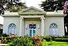
Andrew Carnegie Library |
|
June 29, 1977
(#77000324) |
8th and Main Sts.
33°52′23″N 117°33′56″W / 33.873056°N 117.565556°W / 33.873056; -117.565556 (Andrew Carnegie Library) |
Corona |
Demolished in 1978 |
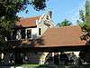
| 15 |
William Childs House |
|
July 28, 1999
(#99000895) |
1151 Monte Vista Dr.
33°57′32″N 117°20′11″W / 33.958889°N 117.336389°W / 33.958889; -117.336389 (William Childs House) |
Riverside |
|
| 16 |
Chinatown |
|
March 1, 1990
(#90000151) |
Brockton and Tequesquite Aves.
33°58′35″N 117°23′05″W / 33.976389°N 117.384722°W / 33.976389; -117.384722 (Chinatown) |
Riverside |
|
| 17 |
Coachella Valley Fish Traps |
|
June 13, 1972
(#72000247) |
Address Restricted
|
Valerie |
|
| 18 |
Coachella Valley Savings No. 2 |
|
December 27, 2016
(#16000885) |
499 S. Palm Canyon Dr.
33°48′58″N 116°32′49″W / 33.816010°N 116.546836°W / 33.816010; -116.546836 (Coachella Valley Savings No. 2) |
Palm Springs |
|
| 19 |
Community Settlement House |
|
December 21, 2017
(#100001906) |
4366 Bermuda Ave.
33°58′15″N 117°21′47″W / 33.970882°N 117.363193°W / 33.970882; -117.363193 (Community Settlement House) |
Riverside |
|
| 20 |
Corn Springs |
|
October 30, 1998
(#98001286) |
Address Restricted
|
Desert Center |
|
| 21 |
Corona High School |
|
August 3, 2005
(#05000772) |
815 W. 6th St.
33°52′35″N 117°34′32″W / 33.876389°N 117.575617°W / 33.876389; -117.575617 (Corona High School) |
Corona |
|
| 22 |
Crescent Bathhouse |
|
July 30, 1975
(#75000453) |
201 W. Graham Ave.
33°40′09″N 117°19′47″W / 33.669167°N 117.329722°W / 33.669167; -117.329722 (Crescent Bathhouse) |
Lake Elsinore |
|
| 23 |
Desert Queen Mine |
|
January 17, 1976
(#76000216) |
S of Twentynine Palms in Joshua Tree National Park
34°01′26″N 116°04′09″W / 34.023889°N 116.069167°W / 34.023889; -116.069167 (Desert Queen Mine) |
Twentynine Palms |
|
| 24 |
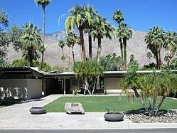
Edris House |
|
December 27, 2016
(#16000886) |
1030 W. Cielo Dr.
33°50′45″N 116°33′40″W / 33.845818°N 116.561211°W / 33.845818; -116.561211 (Edris House) |
Palm Springs |
|
| 25 |
Arthur Elrod House |
|
April 19, 2016
(#16000169) |
2175 Southridge Dr.
33°47′36″N 116°30′39″W / 33.793224°N 116.510745°W / 33.793224; -116.510745 (Arthur Elrod House) |
Palm Springs |
|
| 26 |
Estudillo Mansion |
|
October 25, 2001
(#01001178) |
150 S. Dillon
33°46′51″N 116°58′02″W / 33.780833°N 116.967222°W / 33.780833; -116.967222 (Estudillo Mansion) |
San Jacinto |
|
| 27 |
Federal Post Office |
|
November 20, 1978
(#78000737) |
3720 Orange St.
33°58′55″N 117°22′18″W / 33.981944°N 117.371667°W / 33.981944; -117.371667 (Federal Post Office) |
Riverside |
|
| 28 |
Fire Station No. 1 |
|
September 28, 2015
(#15000636) |
277 N. Indian Canyon Dr.
33°49′34″N 116°32′45″W / 33.8262°N 116.5458°W / 33.8262; -116.5458 (Fire Station No. 1) |
Palm Springs |
|
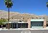
| 29 |
First Church of Christ, Scientist |
|
June 14, 2016
(#16000357) |
605 S. Riverside Dr.
33°48′37″N 116°32′33″W / 33.810209°N 116.542372°W / 33.810209; -116.542372 (First Church of Christ, Scientist) |
Palm Springs |
|
| 30 |
First Church of Christ, Scientist |
|
September 22, 1992
(#92001250) |
3606 Lemon St.
33°58′57″N 117°22′11″W / 33.9825°N 117.369722°W / 33.9825; -117.369722 (First Church of Christ, Scientist) |
Riverside |
|
| 31 |
First Congregational Church of Riverside |
|
April 3, 1997
(#97000297) |
3504 Mission Inn Ave.
33°58′54″N 117°22′16″W / 33.981667°N 117.371111°W / 33.981667; -117.371111 (First Congregational Church of Riverside) |
Riverside |
|
| 32 |
Frey House II |
|
September 28, 2015
(#15000637) |
686 Palisades Dr.
33°49′24″N 116°33′11″W / 33.8233°N 116.553°W / 33.8233; -116.553 (Frey House II) |
Palm Springs |
|
| 33 |
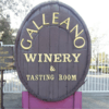
Galleano Winery |
|
June 22, 2003
(#03000533) |
4231 Wineville Rd.
34°00′40″N 117°32′29″W / 34.011111°N 117.541389°W / 34.011111; -117.541389 (Galleano Winery) |
Mira Loma |
|
| 34 |
Rocco Garbani Homestead |
|
December 22, 1999
(#99001593) |
33555 Holland Rd.
33°39′34″N 117°04′24″W / 33.659444°N 117.073333°W / 33.659444; -117.073333 (Rocco Garbani Homestead) |
Winchester |
|
| 35 |
Gilman Ranch |
|
November 17, 1977
(#76000508) |
1937 W. Gilman St.
33°56′15″N 116°53′54″W / 33.9375°N 116.898333°W / 33.9375; -116.898333 (Gilman Ranch) |
Banning |
|
| 36 |
Grand Boulevard Historic District |
|
July 14, 2011
(#11000432) |
Grand Boulevard
33°52′09″N 117°34′02″W / 33.869167°N 117.567222°W / 33.869167; -117.567222 (Grand Boulevard Historic District) |
Corona |
|
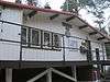
| 37 |
Hamrick House |
|
September 19, 2016
(#16000635) |
875 W. Chino Canyon Rd.
33°50′48″N 116°33′30″W / 33.846712°N 116.558298°W / 33.846712; -116.558298 (Hamrick House) |
Palm Springs |
|
| 38 |
Harada House |
|
September 15, 1977
(#77000325) |
3356 Lemon St.
33°59′06″N 117°22′05″W / 33.985°N 117.368056°W / 33.985; -117.368056 (Harada House) |
Riverside |
|
| 39 |
Heritage House |
|
February 28, 1973
(#73000423) |
8193 Magnolia Ave.
33°56′05″N 117°25′20″W / 33.934722°N 117.422222°W / 33.934722; -117.422222 (Heritage House) |
Riverside |
|
| 40 |
Thomas Jefferson Elementary School |
|
September 28, 2017
(#100001663) |
1040 S. Vicentia Ave.
33°52′19″N 117°34′33″W / 33.871998°N 117.575952°W / 33.871998; -117.575952 (Thomas Jefferson Elementary School) |
Corona |
|
| 41 |
Cornelius Jensen Ranch |
|
September 6, 1979
(#79000519) |
4350 Riverview Dr
33°59′34″N 117°25′01″W / 33.992778°N 117.416944°W / 33.992778; -117.416944 (Cornelius Jensen Ranch) |
Rubidoux |
|
| 42 |
Kenaston House |
|
December 27, 2016
(#16000887) |
39767 Desert Sun Dr.
33°45′34″N 116°25′05″W / 33.759563°N 116.418012°W / 33.759563; -116.418012 (Kenaston House) |
Rancho Mirage |
|
| 43 |
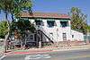
Kocher-Samson Building |
|
September 29, 2015
(#15000638) |
766 N. Palm Canyon Dr.
33°50′01″N 116°32′48″W / 33.8336°N 116.5468°W / 33.8336; -116.5468 (Kocher-Samson Building) |
Palm Springs |
|
| 44 |
Koerner House |
|
December 27, 2016
(#16000888) |
1275 S. Calle de Maria
33°48′22″N 116°31′57″W / 33.806229°N 116.532571°W / 33.806229; -116.532571 (Koerner House) |
Palm Springs |
|
| 45 |
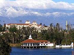
Lake Norconian Club |
|
February 4, 2000
(#00000033) |
Junction of Fifth and Western Ave.
33°55′30″N 117°34′06″W / 33.925°N 117.568333°W / 33.925; -117.568333 (Lake Norconian Club) |
Norco |
|
| 46 |
Gus Lederer Site |
|
March 12, 2003
(#03000118) |
Address Restricted
|
Desert Center |
|
| 47 |
Loewy House |
|
September 29, 2015
(#15000639) |
600 Panorama Rd.
33°50′43″N 116°33′16″W / 33.8454°N 116.5544°W / 33.8454; -116.5544 (Loewy House) |
Palm Springs |
|
| 48 |
Luiseno Ancestral Origin Landscape |
|
October 30, 2014
(#14000851) |
Address Restricted
|
Temecula |
|
| 49 |
March Field Historic District |
|
December 6, 1994
(#94001420) |
Eschscholtzia Ave., March Air Force Base
33°53′59″N 117°15′17″W / 33.899722°N 117.254722°W / 33.899722; -117.254722 (March Field Historic District) |
Riverside |
|
| 50 |
Martinez Canyon Rockhouse |
|
December 14, 1999
(#99001471) |
BLM, Palm Springs-South Coast Resource Area
33°30′20″N 116°19′31″W / 33.505556°N 116.325278°W / 33.505556; -116.325278 (Martinez Canyon Rockhouse) |
North Palm Springs |
|
| 51 |
Martinez Historical District |
|
May 17, 1973
(#73000425) |
Off SR 86
33°33′46″N 116°09′12″W / 33.562778°N 116.153333°W / 33.562778; -116.153333 (Martinez Historical District) |
Torres-Martinez Indian Reservation |
|
| 52 |
Masonic Temple |
|
June 6, 1980
(#80000832) |
3650 11th St.
33°58′43″N 117°22′30″W / 33.978611°N 117.375°W / 33.978611; -117.375 (Masonic Temple) |
Riverside |
|
| 53 |
McCoy Spring Archeological Site |
|
May 10, 1982
(#82002226) |
Address Restricted
|
Blythe |
|
| 54 |
Mission Court Bungalows |
|
July 8, 1993
(#93000549) |
3355-3373 Second St. and 3354-3362 First St.
33°59′12″N 117°21′55″W / 33.986667°N 117.365278°W / 33.986667; -117.365278 (Mission Court Bungalows) |
Riverside |
|
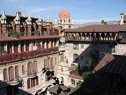
| 55 |
Mission Inn |
|
May 14, 1971
(#71000173) |
3649 7th St.
33°59′00″N 117°22′18″W / 33.983333°N 117.371667°W / 33.983333; -117.371667 (Mission Inn) |
Riverside |
|
| 56 |
Mount San Jacinto State Park Historic District |
|
June 25, 2013
(#13000416) |
25905 CA 243
33°45′01″N 116°42′52″W / 33.750321°N 116.714344°W / 33.750321; -116.714344 (Mount San Jacinto State Park Historic District) |
Idyllwild |
|
| 57 |
Murrieta Creek Archeological Area |
|
April 24, 1973
(#73000424) |
Address Restricted
|
Temecula |
|
| 58 |
North Chuckwalla Mountain Quarry District |
|
August 24, 1981
(#81000165) |
Address Restricted
|
Desert Center |
|
| 59 |
North Chuckwalla Mountains Petroglyph District Ca-Riv 1383 |
|
September 3, 1981
(#81000166) |
Address Restricted
|
Desert Center |
|
| 60 |
North Shore Yacht Club |
|
September 28, 2015
(#15000640) |
99-155 Sea View Dr.
33°31′10″N 115°56′14″W / 33.5194°N 115.9372°W / 33.5194; -115.9372 (North Shore Yacht Club) |
Mecca |
|
| 61 |
Thomas O'Donnell House |
|
January 7, 2011
(#10001123) |
447 Alejo Rd.
33°49′49″N 116°33′09″W / 33.830278°N 116.5525°W / 33.830278; -116.5525 (Thomas O'Donnell House) |
Palm Springs |
|
| 62 |
Old YWCA Building |
|
January 28, 1982
(#82002227) |
3425 Mission Inn Avenue
33°58′54″N 117°22′14″W / 33.981722°N 117.370472°W / 33.981722; -117.370472 (Old YWCA Building) |
Riverside |
|
| 63 |
Palm Springs Aerial Tramway Mountain Station |
|
December 27, 2016
(#16000889) |
1 Tram Way
33°48′47″N 116°38′19″W / 33.813107°N 116.638517°W / 33.813107; -116.638517 (Palm Springs Aerial Tramway Mountain Station) |
Idyllwild vicinity |
|
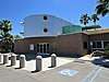
| 64 |
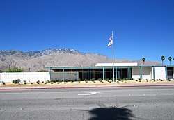
Palm Springs City Hall |
|
September 29, 2015
(#15000641) |
3200 E. Tahquitz Canyon Way
33°49′25″N 116°30′42″W / 33.8236°N 116.5117°W / 33.8236; -116.5117 (Palm Springs City Hall) |
Palm Springs |
|
| 65 |
Palm Springs Desert Museum |
|
December 27, 2016
(#16000890) |
101 Museum Dr.
33°49′27″N 116°33′00″W / 33.824167°N 116.55°W / 33.824167; -116.55 (Palm Springs Desert Museum) |
Palm Springs |
|
| 66 |
Palm Springs Tramway Valley Station |
|
September 28, 2015
(#15000642) |
1 Tram Way
33°50′15″N 116°36′50″W / 33.8374°N 116.6139°W / 33.8374; -116.6139 (Palm Springs Tramway Valley Station) |
Palm Springs |
|
| 67 |
Palm Springs Unified School District Educational Administrative Center |
|
December 27, 2016
(#16000891) |
333 S. Farrell Dr.
33°49′08″N 116°31′06″W / 33.818968°N 116.518243°W / 33.818968; -116.518243 (Palm Springs Unified School District Educational Administrative Center) |
Palm Springs |
|
| 68 |
Pearlman Mountain Cabin |
|
April 19, 2016
(#16000173) |
52820 Middleridge Dr.
33°43′50″N 116°44′27″W / 33.730422°N 116.740797°W / 33.730422; -116.740797 (Pearlman Mountain Cabin) |
Idyllwild |
|
| 69 |
Perris Depot |
|
August 5, 1994
(#94000819) |
120 W. Fourth St.
33°46′58″N 117°13′46″W / 33.782639°N 117.229314°W / 33.782639; -117.229314 (Perris Depot) |
Perris |
|
| 70 |
Riverside Municipal Auditorium and Soldiers' Memorial Building |
|
March 31, 1978
(#78000738) |
3485 7th St.
33°58′55″N 117°22′12″W / 33.981944°N 117.37°W / 33.981944; -117.37 (Riverside Municipal Auditorium and Soldiers' Memorial Building) |
Riverside |
|
| 71 |
Riverside-Arlington Heights Fruit Exchange |
|
June 9, 1980
(#80000833) |
3391 7th St.
33°58′52″N 117°22′10″W / 33.981111°N 117.369444°W / 33.981111; -117.369444 (Riverside-Arlington Heights Fruit Exchange) |
Riverside |
|
| 72 |
Ryan House and Lost Horse Well |
|
June 5, 1975
(#75000175) |
S of Twentynine Palms in Joshua Tree National Park
33°59′06″N 116°08′52″W / 33.985°N 116.147778°W / 33.985; -116.147778 (Ryan House and Lost Horse Well) |
Twentynine Palms |
|
| 73 |
San Pedro, Los Angeles, & Salt Lake RR Depot |
|
April 18, 1977
(#77000326) |
3751 Vine St.
33°58′45″N 117°21′59″W / 33.979167°N 117.366389°W / 33.979167; -117.366389 (San Pedro, Los Angeles, & Salt Lake RR Depot) |
Riverside |
|
| 74 |
San Timoteo Canyon Schoolhouse |
|
January 19, 2001
(#00001646) |
31985 San Timoteo Canyon Rd.
33°58′33″N 117°06′10″W / 33.975833°N 117.102778°W / 33.975833; -117.102778 (San Timoteo Canyon Schoolhouse) |
Redlands |
|
| 75 |
Santa Fe Federal Savings and Loan Association |
|
December 27, 2016
(#16000892) |
300 S. Palm Canyon Dr.
33°49′09″N 116°32′48″W / 33.819162°N 116.546725°W / 33.819162; -116.546725 (Santa Fe Federal Savings and Loan Association) |
Palm Springs |
|
| 76 |
Sieroty House |
|
September 28, 2015
(#15000643) |
695 E. Vereda Sur
33°50′19″N 116°32′22″W / 33.838598°N 116.539524°W / 33.838598; -116.539524 (Sieroty House) |
Palm Springs |
|
| 77 |
M. H. Simon's Undertaking Chapel |
|
June 9, 1980
(#80000834) |
3610 11th St.
33°58′43″N 117°22′29″W / 33.978611°N 117.374722°W / 33.978611; -117.374722 (M. H. Simon's Undertaking Chapel) |
Riverside |
|
| 78 |
Frank Sinatra House |
|
December 27, 2016
(#16000893) |
1145 E. Via Colusa Rd.
33°49′52″N 116°32′01″W / 33.831202°N 116.533642°W / 33.831202; -116.533642 (Frank Sinatra House) |
Palm Springs |
|
| 79 |
Southern Hotel |
|
October 15, 1992
(#92001384) |
445 S. D St.
33°46′55″N 117°13′42″W / 33.781833°N 117.228417°W / 33.781833; -117.228417 (Southern Hotel) |
Perris |
|
| 80 |
Steel Development House Number 2 |
|
March 20, 2012
(#12000125) |
3125 N. Sunny View Dr.
33°51′30″N 116°32′40″W / 33.858228°N 116.544324°W / 33.858228; -116.544324 (Steel Development House Number 2) |
Riverside |
|
| 81 |
Sutherland Fruit Company |
|
April 11, 1986
(#86000732) |
3191 Seventh St.
33°58′50″N 117°21′59″W / 33.980556°N 117.366389°W / 33.980556; -117.366389 (Sutherland Fruit Company) |
Riverside |
|
| 82 |
Tahquitz Canyon |
|
October 31, 1972
(#72000246) |
500 West Mesquite
33°48′31″N 116°33′02″W / 33.808592°N 116.550491°W / 33.808592; -116.550491 (Tahquitz Canyon) |
Palm Springs |
|
| 83 |
Tramway Gas Station |
|
September 28, 2015
(#15000645) |
2901 N. Palm Canyon Dr.
33°51′30″N 116°33′29″W / 33.8582°N 116.5580°W / 33.8582; -116.5580 (Tramway Gas Station) |
Palm Springs |
Now the Palm Springs Visitor Center |
| 84 |
University Heights Junior High School |
|
June 24, 1993
(#93000547) |
2060 University Ave.
33°58′30″N 117°21′20″W / 33.975°N 117.355556°W / 33.975; -117.355556 (University Heights Junior High School) |
Riverside |
|
| 85 |
Victoria Avenue |
|
October 26, 2000
(#00001267) |
Victoria Ave., from Arlington Ave. to Boundary Ln.
33°55′33″N 117°23′57″W / 33.925833°N 117.399167°W / 33.925833; -117.399167 (Victoria Avenue) |
Riverside |
|
| 86 |
E. Stewart and Mari Williams House |
|
December 27, 2016
(#16000894) |
Address restricted
|
Palm Springs |
|
| 87 |
Woman's Improvement Club Clubhouse |
|
November 3, 1988
(#88002014) |
1101 S. Main St.
33°52′12″N 117°33′58″W / 33.87°N 117.566111°W / 33.87; -117.566111 (Woman's Improvement Club Clubhouse) |
Corona |
|
.jpg)

.jpg)
.jpg)