| [3] |
Name on the Register[4] |
Image |
Date listed[5] |
Location |
City or town |
Description |
|---|
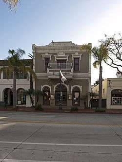
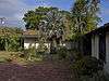
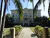
| 1 |
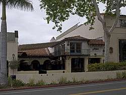
Acacia Lodge |
|
July 9, 1997
(#97000750) |
109 Miramar Ave.
34°25′22″N 119°37′49″W / 34.422778°N 119.630278°W / 34.422778; -119.630278 (Acacia Lodge) |
Santa Barbara |
|
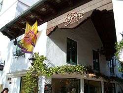
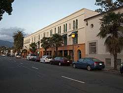
| 2 |
Andalucia Building |
|
December 22, 1999
(#99001592) |
316-324 State St.
34°24′57″N 119°41′37″W / 34.41575°N 119.69373°W / 34.41575; -119.69373 (Andalucia Building) |
Santa Barbara |
|
| 3 |
Campbell No. 2 Archeological Site |
|
January 25, 1993
(#92001755) |
Address Restricted
|
Goleta |
|
| 4 |
Eastern Sierra Madre Ridge Archeological District |
|
December 19, 1978
(#78000779) |
Address Restricted
|
New Cuyama |
|
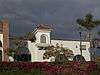
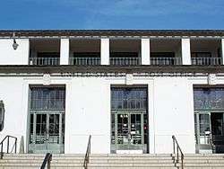
| 5 |
El Paseo and Casa de la Guerra |
|
February 2, 1977
(#77000346) |
808-818 State St., 813-819 Anacapa St., and 9-25 E. de la Guerra St.
34°25′14″N 119°41′57″W / 34.42061°N 119.69928°W / 34.42061; -119.69928 (El Paseo and Casa de la Guerra) |
Santa Barbara |
El Paseo and Casa de la Guerra |
| 6 |
Faith Mission |
|
January 11, 1982
(#82002269) |
409 State St.
34°24′58″N 119°41′41″W / 34.416°N 119.69475°W / 34.416; -119.69475 (Faith Mission) |
Santa Barbara |
Designed by Peter J. Barber |
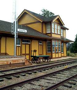
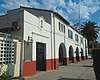
| 7 |
Goleta Depot |
|
January 18, 2002
(#01001457) |
300 N. Los Carneros Rd.
34°26′33″N 119°51′09″W / 34.44244°N 119.85261°W / 34.44244; -119.85261 (Goleta Depot) |
Goleta |
A 1901 Southern Pacific train station, now located at the South Coast Railroad Museum |
| 8 |
Rafael Gonzalez House |
|
April 15, 1970
(#70000149) |
835 Laguna St.
34°25′27″N 119°41′45″W / 34.424217°N 119.695856°W / 34.424217; -119.695856 (Rafael Gonzalez House) |
Santa Barbara |
A National Historic Landmark |
| 9 |
Hammond's Estate Site |
|
May 19, 1978
(#78000782) |
Address Restricted
|
Santa Barbara |
|
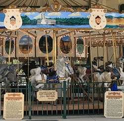
| 10 |
Allan Herschell 3-Abreast Carousel |
|
April 13, 2000
(#00000363) |
223 E. Cabrillo Blvd.
34°24′54″N 119°41′10″W / 34.415°N 119.68598°W / 34.415; -119.68598 (Allan Herschell 3-Abreast Carousel) |
Santa Barbara |
|
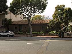
| 11 |
Hill-Carrillo Adobe |
|
January 14, 1986
(#86000778) |
11 E. Carrillo St.
34°25′19″N 119°42′06″W / 34.421944°N 119.701736°W / 34.421944; -119.701736 (Hill-Carrillo Adobe) |
Santa Barbara |
|
| 12 |
Thomas Hope House |
|
December 1, 1978
(#78000783) |
399 Nogal Dr.
34°26′06″N 119°46′15″W / 34.43504°N 119.77093°W / 34.43504; -119.77093 (Thomas Hope House) |
Santa Barbara |
Designed by Peter J. Barber |
| 13 |
Janssens-Orella-Birk Building |
|
July 16, 1987
(#87001170) |
1029-1031 State St.
34°25′20″N 119°42′11″W / 34.422111°N 119.703056°W / 34.422111; -119.703056 (Janssens-Orella-Birk Building) |
Santa Barbara |
|
| 14 |
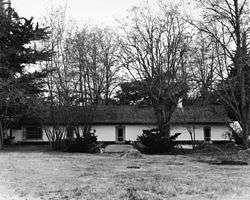
La Purisima Mission |
|
April 15, 1970
(#70000147) |
4 mi. E of Lompoc, near jct. of CA 1 and 150
34°40′31″N 120°25′19″W / 34.675322°N 120.421811°W / 34.675322; -120.421811 (La Purisima Mission) |
Lompoc |
A National Historic Landmark |
| 15 |
Lompoc Public Library |
|
December 10, 1990
(#90001818) |
200 S. H St.
34°38′14″N 120°27′27″W / 34.63713°N 120.45759°W / 34.63713; -120.45759 (Lompoc Public Library) |
Lompoc |
|
| 16 |
Lompoc Veterans Memorial Building |
|
September 19, 2016
(#16000664) |
100 E. Locust Ave.
34°37′57″N 120°27′28″W / 34.632485°N 120.457677°W / 34.632485; -120.457677 (Lompoc Veterans Memorial Building) |
Lompoc |
|
| 17 |
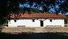
Los Alamos Ranch House |
|
April 15, 1970
(#70000148) |
3 mi. W of Los Alamos on old U.S. 101
Coordinates missing |
Los Alamos |
A National Historic Landmark |
| 18 |
Los Banos del Mar |
|
December 24, 1992
(#92001726) |
401 Shoreline Dr.
34°24′28″N 119°41′38″W / 34.40774°N 119.69392°W / 34.40774; -119.69392 (Los Banos del Mar) |
Santa Barbara |
|
| 19 |
Madulce Guard Station and Site |
|
December 11, 1979
(#79000547) |
40 mi. N. of Santa Barbara
34°42′11″N 119°34′42″W / 34.703056°N 119.578333°W / 34.703056; -119.578333 (Madulce Guard Station and Site) |
Santa Barbara |
Destroyed by fire in 1999.[6] |
| 20 |
Minerva Club of Santa Maria |
|
September 20, 1984
(#84001193) |
127 W. Boone St.
34°56′51″N 120°26′14″W / 34.94741°N 120.43722°W / 34.94741; -120.43722 (Minerva Club of Santa Maria) |
Santa Maria |
|
| 21 |
Mission de la Purisima Concepcion de Maria Santisima Site |
|
May 5, 1978
(#78000775) |
Bounded by Locust Ave., city limits, E and G Sts.
34°37′55″N 120°27′23″W / 34.631944°N 120.456389°W / 34.631944; -120.456389 (Mission de la Purisima Concepcion de Maria Santisima Site) |
Lompoc |
|
| 22 |
Mission Santa Ines |
|
March 8, 1999
(#99000630) |
E side of Solvang, S of CA 246
34°35′37″N 120°08′14″W / 34.593611°N 120.13716°W / 34.593611; -120.13716 (Mission Santa Ines) |
Solvang |
A National Historic Landmark District |
| 23 |
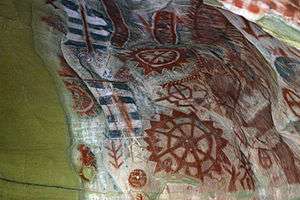
Painted Cave |
|
December 5, 1972
(#72000256) |
Address Restricted
|
Santa Barbara |
|
| 24 |
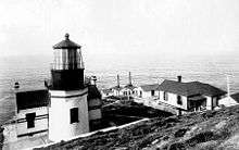
Point Conception Light Station |
|
February 25, 1981
(#81000176) |
U.S. Coast Guard Light Station
34°26′55″N 120°28′15″W / 34.44867°N 120.47084°W / 34.44867; -120.47084 (Point Conception Light Station) |
Santa Barbara |
|
| 25 |
Point Sal Ataje |
|
November 21, 2002
(#02001392) |
Address Restricted
|
Point Sal Highlands |
|
| 26 |
Rattlesnake Canyon Bridge |
|
January 17, 2017
(#100000465) |
1819 Las Canoas Rd.
34°27′27″N 119°41′32″W / 34.457586°N 119.692231°W / 34.457586; -119.692231 (Rattlesnake Canyon Bridge) |
Santa Barbara |
|
| 27 |
San Marcos Rancho |
|
April 26, 1979
(#79000548) |
Address Restricted
|
Santa Barbara |
|
| 28 |
San Miguel Island Archeological District |
|
September 12, 1979
(#79000258) |
Address Restricted
|
Santa Barbara |
|
| 29 |
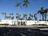
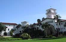
Santa Barbara County Courthouse |
|
January 23, 1981
(#81000177) |
1100 Anacapa St.
34°25′28″N 119°42′09″W / 34.42435°N 119.702461°W / 34.42435; -119.702461 (Santa Barbara County Courthouse) |
Santa Barbara |
A National Historic Landmark |
| 30 |
Santa Barbara Island Archeological District |
|
September 12, 1979
(#79000259) |
Address Restricted
|
Santa Barbara |
|
| 31 |
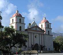
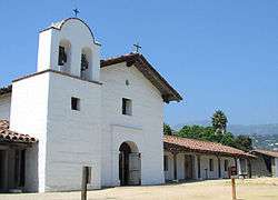
Santa Barbara Mission |
|
October 15, 1966
(#66000237) |
2201 Laguna St.
34°26′16″N 119°42′50″W / 34.437803°N 119.714025°W / 34.437803; -119.714025 (Santa Barbara Mission) |
Santa Barbara |
A National Historic Landmark |
| 32 |
Santa Barbara Presidio |
|
November 26, 1973
(#73000455) |
Roughly bounded by Carrillo, Garden, De la Guerra and Anacapa Sts.
34°25′21″N 119°41′50″W / 34.4225°N 119.697222°W / 34.4225; -119.697222 (Santa Barbara Presidio) |
Santa Barbara |
|
| 33 |
Santa Barbara Veterans Memorial Building |
|
March 22, 2016
(#16000097) |
112 W. Cabrillo St.
34°24′39″N 119°41′27″W / 34.410903°N 119.690942°W / 34.410903; -119.690942 (Santa Barbara Veterans Memorial Building) |
Santa Barbara |
Remodeled in 1937 in the Spanish Colonial Revival style from a 1927 building |
| 34 |
Santa Cruz Island Archeological District |
|
January 30, 1980
(#80000405) |
Address Restricted
|
Santa Barbara |
|
| 35 |
Joseph and Lucy Foster Sexton House |
|
February 5, 1992
(#91002033) |
5490 Hollister Ave.
34°26′09″N 119°48′55″W / 34.435833°N 119.815278°W / 34.435833; -119.815278 (Joseph and Lucy Foster Sexton House) |
Santa Barbara |
Italianate, designed by Peter J. Barber |
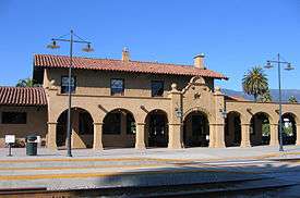
| 36 |
Southern Pacific Train Depot |
|
August 2, 2006
(#06000658) |
209 State St.
34°24′49″N 119°41′34″W / 34.413611°N 119.69283°W / 34.413611; -119.69283 (Southern Pacific Train Depot) |
Santa Barbara |
|
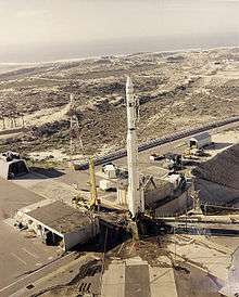
| 37 |
Space Launch Complex 10 |
|
June 23, 1986
(#86003511) |
Vandenberg Air Force Base
34°45′55″N 120°37′20″W / 34.765278°N 120.622222°W / 34.765278; -120.622222 (Space Launch Complex 10) |
Lompoc |
A National Historic Landmark |
| 38 |
SS YANKEE BLADE |
|
May 16, 1991
(#91000564) |
Address Restricted
|
Lompoc |
|
| 39 |
St. Vincent Orphanage and School Building |
|
June 2, 1982
(#82002270) |
925 De La Vina St.
34°25′08″N 119°42′15″W / 34.418889°N 119.70406°W / 34.418889; -119.70406 (St. Vincent Orphanage and School Building) |
Santa Barbara |
|
| 40 |
Steedman Estate |
|
January 29, 1987
(#87000002) |
1387 E. Valley Rd.
34°26′10″N 119°38′12″W / 34.43612°N 119.63674°W / 34.43612; -119.63674 (Steedman Estate) |
Montecito |
National Historic Landmark designation January 16, 2009 |
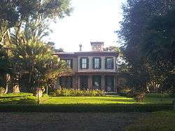
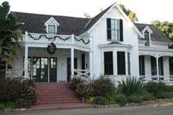
| 41 |
Stow House |
|
September 28, 2000
(#00001166) |
304 N. Los Carneros Rd.
34°26′35″N 119°51′06″W / 34.44305°N 119.85179°W / 34.44305; -119.85179 (Stow House) |
Goleta |
|
| 42 |
US Post Office-Santa Barbara Main |
|
January 11, 1985
(#85000138) |
836 Anacapa St.
34°25′18″N 119°41′56″W / 34.421667°N 119.698889°W / 34.421667; -119.698889 (US Post Office-Santa Barbara Main) |
Santa Barbara |
|
| 43 |
Val Verde |
|
March 31, 1995
(#95000359) |
2549 Sycamore Canyon Rd.
34°26′26″N 119°38′58″W / 34.44068°N 119.64953°W / 34.44068; -119.64953 (Val Verde) |
Santa Barbara |
Santa Barbara County landmark number: 38 Also known as: Dias Felices, Henry Dater house, Wright Ludington house, Dr. Warren Austin home |
| 44 |
Virginia Hotel |
|
March 31, 2000
(#00000295) |
17 and 23 W. Haley St.
34°24′58″N 119°41′46″W / 34.416111°N 119.696111°W / 34.416111; -119.696111 (Virginia Hotel) |
Santa Barbara |
|