| [3] |
Name on the Register[4] |
Image |
Date listed[5] |
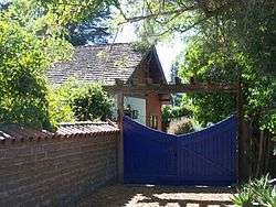
Location |
City or town |
Description |
|---|
| 1 |
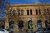
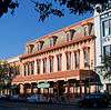
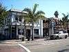
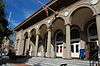
Bank of Santa Cruz County |
|
March 15, 1982
(#82002273) |
1502 Pacific Ave.
36°58′31″N 122°01′31″W / 36.975278°N 122.025278°W / 36.975278; -122.025278 (Bank of Santa Cruz County) |
Santa Cruz |
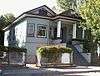
Following the 1989 Loma Prieta earthquake, most of the building was demolished. The two stone-faced exterior walls, however, were saved. A new structure was built behind them. |
| 2 |
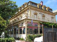
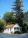
Bayview Hotel |
|
March 30, 1992
(#92000259) |
8041 Soquel Dr.
36°58′39″N 121°53′58″W / 36.9775°N 121.899444°W / 36.9775; -121.899444 (Bayview Hotel) |
Aptos |
Built in 1878 |
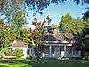
| 3 |
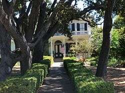
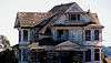
Godfrey M. Bockius House |
|
July 13, 1989
(#89000937) |
322 E. Beach St.
36°54′58″N 121°44′51″W / 36.916111°N 121.7475°W / 36.916111; -121.7475 (Godfrey M. Bockius House) |
Watsonville |
|
| 4 |
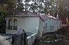
Branciforte Adobe |
|
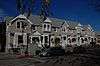
January 31, 1979
(#79000552) |
1351 N. Branciforte Ave.
36°59′23″N 122°00′35″W / 36.989722°N 122.009722°W / 36.989722; -122.009722 (Branciforte Adobe) |
Santa Cruz |
|
| 5 |
Allan Brown Site |
|
June 25, 1981
(#81000178) |
Address Restricted
|
Santa Cruz |
|
| 6 |
California Powder Works Bridge |
|
February 27, 2015
(#15000279) |
Spanning San Lorenzo River at Keystone Way, Paradise Park
37°00′38″N 122°02′42″W / 37.0106°N 122.045°W / 37.0106; -122.045 (California Powder Works Bridge) |
Santa Cruz |
|
| 7 |
Carmelita Court |
|
March 20, 1986
(#86000456) |
315-321 Main St.
36°57′56″N 122°01′20″W / 36.965556°N 122.022222°W / 36.965556; -122.022222 (Carmelita Court) |
Santa Cruz |
|
| 8 |
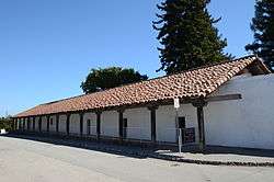
Jose Joaquin Castro Adobe |
|
December 12, 1976
(#76000531) |
NW of Watsonville at 184 Old Adobe Rd.
36°56′46″N 121°48′40″W / 36.946111°N 121.811111°W / 36.946111; -121.811111 (Jose Joaquin Castro Adobe) |
Watsonville |
|
| 9 |
Cope Row Houses |
|
January 28, 1982
(#82002274) |
412-420 Lincoln St.
36°58′20″N 122°01′49″W / 36.972222°N 122.030278°W / 36.972222; -122.030278 (Cope Row Houses) |
Santa Cruz |
located in the Santa Cruz Downtown Historic District |
| 10 |
Cowell Lime Works Historic District |
|
November 21, 2007
(#07001220) |
University of California, Santa Cruz campus; High St. and Glen Coolidge Dr.
36°58′41″N 122°03′08″W / 36.978102°N 122.052132°W / 36.978102; -122.052132 (Cowell Lime Works Historic District) |
Santa Cruz |
On ranch land once owned by the Henry Cowell family, now part of the University of California, Santa Cruz campus |
| 11 |
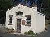
Davenport Jail |
|
April 27, 1992
(#92000422) |
1 Center St.
37°00′38″N 122°11′31″W / 37.010556°N 122.191944°W / 37.010556; -122.191944 (Davenport Jail) |
Davenport |
|
| 12 |
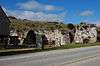
Felton Covered Bridge |
|
June 19, 1973
(#73000451) |
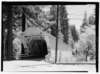
Covered Bridge Road
37°03′03″N 122°04′15″W / 37.050797°N 122.070956°W / 37.050797; -122.070956 (Felton Covered Bridge) |
Felton |
An 1890s wooden covered Brown truss bridge, tallest covered bridge in the U.S., entrance to Felton for 45 years, part of park now. |
| 13 |
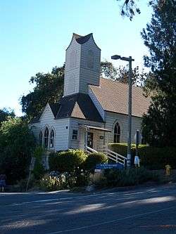
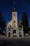
Felton Presbyterian Church |
|
April 6, 1978
(#78000774) |
6299 Gushee St.
37°03′10″N 122°04′24″W / 37.052778°N 122.073333°W / 37.052778; -122.073333 (Felton Presbyterian Church) |
Felton |
|
| 14 |
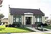
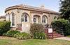
Garfield Park Branch Library |
|
March 26, 1992
(#92000268) |
705 Woodrow Ave.
36°57′29″N 122°02′16″W / 36.958056°N 122.037778°W / 36.958056; -122.037778 (Garfield Park Branch Library) |
Santa Cruz |
|
| 15 |
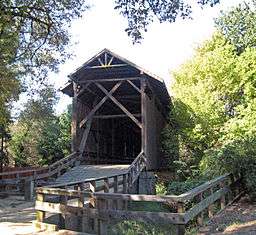
Glen Canyon Covered Bridge |
|
May 17, 1984
(#84001194) |
Branciforte Dr.
37°00′00″N 122°00′08″W / 37.0°N 122.002222°W / 37.0; -122.002222 (Glen Canyon Covered Bridge) |
Santa Cruz |
demolished |
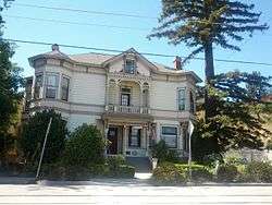
| 16 |
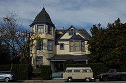
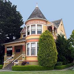
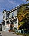
Golden Gate Villa |
|
July 24, 1975
(#75000482) |
924 3rd St.
36°58′02″N 122°01′18″W / 36.967222°N 122.021667°W / 36.967222; -122.021667 (Golden Gate Villa) |
Santa Cruz |
|
| 17 |
Grace Episcopal Church |
|
December 19, 2006
(#06001158) |
12547 CA 9
37°07′00″N 122°07′11″W / 37.116667°N 122.119722°W / 37.116667; -122.119722 (Grace Episcopal Church) |
Boulder Creek |
|
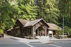
| 18 |
Headquarters Administration Building |
|
December 22, 2015
(#15000914) |
21600 Big Basin Way, Big Basin Redwoods State Park
37°10′19″N 122°13′20″W / 37.172070°N 122.222281°W / 37.172070; -122.222281 (Headquarters Administration Building) |
Boulder Creek |
|
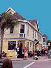
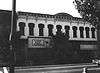
| 19 |
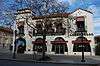
Hihn Building |
|
March 20, 1973
(#73000450) |
201 Monterey Ave.
36°58′23″N 121°56′58″W / 36.973056°N 121.949444°W / 36.973056; -121.949444 (Hihn Building) |
Capitola |
|
| 20 |
A. J. Hinds House |
|
August 25, 1983
(#83001241) |
529 Chestnut St.
36°58′25″N 122°01′48″W / 36.973611°N 122.03°W / 36.973611; -122.03 (A. J. Hinds House) |
Santa Cruz |
located in the Santa Cruz Downtown Historic District |
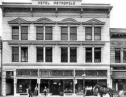
| 21 |
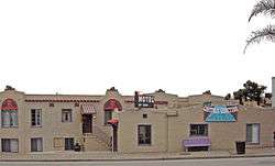
Hotel Metropole |
|
May 23, 1979
(#79000553) |
1111 Pacific Ave.
36°58′19″N 122°01′29″W / 36.971944°N 122.024722°W / 36.971944; -122.024722 (Hotel Metropole) |
Santa Cruz |
demolished after 1989 Loma Prieta earthquake |
| 22 |
Judge Lee House |
|
June 30, 1980
(#80000868) |
128 E. Beach St.
36°54′42″N 121°45′13″W / 36.911667°N 121.753611°W / 36.911667; -121.753611 (Judge Lee House) |
Watsonville |
|
| 23 |
Lettunich Building |
|
September 24, 1992
(#92001278) |
406 Main St.
36°54′37″N 121°45′19″W / 36.910278°N 121.755278°W / 36.910278; -121.755278 (Lettunich Building) |
Watsonville |
|
| 24 |
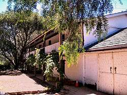
Live Oak Ranch |
|
July 10, 1975
(#75000483) |
105 Mentel Ave.
36°58′38″N 121°59′57″W / 36.977222°N 121.999167°W / 36.977222; -121.999167 (Live Oak Ranch) |
Santa Cruz |
|
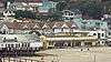
| 25 |
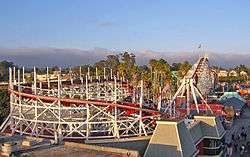
Looff Carousel and Roller Coaster on the Santa Cruz Beach Boardwalk |
|
February 27, 1987
(#87000764) |
Along Beach St.
36°57′52″N 122°00′51″W / 36.964444°N 122.014167°W / 36.964444; -122.014167 (Looff Carousel and Roller Coaster on the Santa Cruz Beach Boardwalk) |
Santa Cruz |
|
| 26 |
Lower Sky Meadow Residential Area Historic District |
|
September 24, 2014
(#14000662) |
7, 8, 9, 10, 14, 15 & 16 Sky Meadow Ln.
37°10′57″N 122°12′20″W / 37.182432°N 122.205580°W / 37.182432; -122.205580 (Lower Sky Meadow Residential Area Historic District) |
Boulder Creek |
|
| 27 |
Madison House |
|
February 2, 1984
(#84001195) |
335 East Lake
36°54′57″N 121°45′06″W / 36.915833°N 121.751667°W / 36.915833; -121.751667 (Madison House) |
Watsonville |
|
| 28 |
Mansion House Hotel |
|
August 18, 1983
(#83001242) |
418-424 Main St.
36°54′38″N 121°45′21″W / 36.910556°N 121.755833°W / 36.910556; -121.755833 (Mansion House Hotel) |
Watsonville |
|
| 29 |
Mission Hill Area Historic District |
|
May 17, 1976
(#76000530) |
Mission St.
36°58′39″N 122°01′43″W / 36.9775°N 122.028611°W / 36.9775; -122.028611 (Mission Hill Area Historic District) |
Santa Cruz |
The present Holy Cross Church was built in 1889, on the site of the original Mission Santa Cruz |
| 30 |
Neary-Rodriguez Adobe |
|
February 24, 1975
(#75000484) |
130-134 School St.
36°58′40″N 122°01′39″W / 36.977778°N 122.0275°W / 36.977778; -122.0275 (Neary-Rodriguez Adobe) |
Santa Cruz |
part of the Mission Hill Area Historic District |
| 31 |
Octagon Building |
|
March 24, 1971
(#71000193) |
Corner of Front and Cooper Sts.
36°58′29″N 122°01′29″W / 36.974722°N 122.024722°W / 36.974722; -122.024722 (Octagon Building) |
Santa Cruz |
|
| 32 |
Old Riverview Historic District |
|
January 22, 1988
(#87000626) |
Blue Gum Ave., Capitola Ave., Riverview Ave., Riverview Dr., and Wharf Rd.
36°58′27″N 121°57′12″W / 36.974167°N 121.953333°W / 36.974167; -121.953333 (Old Riverview Historic District) |
Capitola |
|
| 33 |
Phillipshurst-Riverwood |
|
August 4, 1983
(#83004369) |
CA 9
37°06′02″N 122°05′58″W / 37.100556°N 122.099444°W / 37.100556; -122.099444 (Phillipshurst-Riverwood) |
Ben Lomond |
|
| 34 |
Redman House |
|
July 28, 2004
(#04000734) |
1635 W. Beach Dr.
36°53′47″N 121°46′33″W / 36.896389°N 121.775833°W / 36.896389; -121.775833 (Redman House) |
Watsonville |
|
| 35 |
Rispin Mansion |
|
March 14, 1991
(#91000286) |
2200 Wharf Rd.
36°58′43″N 121°57′22″W / 36.978611°N 121.956111°W / 36.978611; -121.956111 (Rispin Mansion) |
Capitola |
|
| 36 |
Elias H. Robinson House |
|
January 9, 1998
(#97001634) |
363 Ocean St.
36°58′24″N 122°01′02″W / 36.973333°N 122.017222°W / 36.973333; -122.017222 (Elias H. Robinson House) |
Santa Cruz |
|
| 37 |
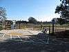
Sand Hill Bluff Site |
|
June 20, 2008
(#08000528) |
Address Restricted
|
Santa Cruz |
|
| 38 |
Santa Cruz Downtown Historic District |
|
July 27, 1989
(#89001005) |
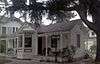
Roughly Rincon St., Church St., Chestnut St., Walnut St., Cedar St., Laurel St., Myrtle St., and Lincoln St.
36°58′15″N 122°02′23″W / 36.970833°N 122.039722°W / 36.970833; -122.039722 (Santa Cruz Downtown Historic District) |
Santa Cruz |
An 1870s house, typical of this Historic District |
| 39 |
Hiram D. Scott House |
|
April 13, 1977
(#77000348) |
4603 Scotts Valley Drive
37°02′57″N 122°01′02″W / 37.049167°N 122.017222°W / 37.049167; -122.017222 (Hiram D. Scott House) |
Scotts Valley |
|
| 40 |
Six Sisters-Lawn Way Historic District |
|
May 1, 1987
(#87000623) |
Roughly bounded by San Jose Ave., Capitola Ave., and Esplanade
36°58′21″N 121°57′40″W / 36.9725°N 121.961111°W / 36.9725; -121.961111 (Six Sisters-Lawn Way Historic District) |
Capitola |
|
| 41 |
Stoesser Block and Annex |
|
April 7, 1983
(#83001243) |
331–341 Main St.
36°54′34″N 121°45′20″W / 36.909444°N 121.755556°W / 36.909444; -121.755556 (Stoesser Block and Annex) |
Watsonville |
Demolished prior to 2000.[6] |
| 42 |
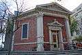
US Post Office-Santa Cruz Main |
|
January 11, 1985
(#85000139) |
850 Front St.
36°58′36″N 122°01′33″W / 36.976667°N 122.025833°W / 36.976667; -122.025833 (US Post Office-Santa Cruz Main) |
Santa Cruz |
|
| 43 |
Valencia Hall |
|
September 20, 1984
(#84001201) |
Valencia Rd.
36°59′47″N 121°51′55″W / 36.996389°N 121.865278°W / 36.996389; -121.865278 (Valencia Hall) |
Aptos |
|
| 44 |
Venetian Court Apartments |
|
April 2, 1987
(#87000574) |
1500 Wharf Rd.
36°58′22″N 121°57′08″W / 36.972778°N 121.952222°W / 36.972778; -121.952222 (Venetian Court Apartments) |
Capitola |
1924 condominuiums |
| 45 |
Veterans Memorial Building |
|
April 27, 1992
(#92000423) |
842-846 Front St.
36°58′34″N 122°01′29″W / 36.976111°N 122.024722°W / 36.976111; -122.024722 (Veterans Memorial Building) |
Santa Cruz |
|
| 46 |
Watsonville City Plaza |
|
August 22, 1983
(#83001244) |
Bounded by Main, Peck, Union, and E. Beach Cts.
36°54′37″N 121°45′17″W / 36.910278°N 121.754722°W / 36.910278; -121.754722 (Watsonville City Plaza) |
Watsonville |
|
| 47 |
Watsonville-Lee Road Site |
|
May 28, 1976
(#76000532) |
Address Restricted
|
Watsonville |
|
| 48 |
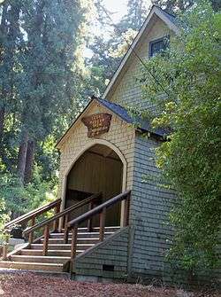
Wee Kirk |
|
October 12, 2017
(#100001730) |
9500 Central Ave.
37°05′26″N 122°05′24″W / 37.090682°N 122.090059°W / 37.090682; -122.090059 (Wee Kirk) |
Ben Lomond |
|
.jpg)
.jpg)
.jpg)