National Register of Historic Places listings in Modoc County, California
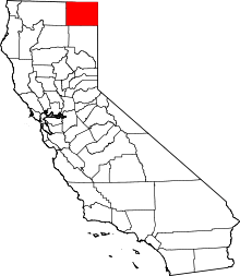
Location of Modoc County in California
This is a list of the National Register of Historic Places listings in Modoc County, California.
This is intended to be a complete list of the properties and districts on the National Register of Historic Places in Modoc County, California, United States. Latitude and longitude coordinates are provided for many National Register properties and districts; these locations may be seen together in a Google map.[1]
There are 18 properties and districts listed on the National Register in the county, including 1 National Historic Landmark.
- This National Park Service list is complete through NPS recent listings posted October 4, 2018.[2]
Current listings
| [3] | Name on the Register[4] | Image | Date listed[5] | Location | City or town | Description |
|---|---|---|---|---|---|---|
| 1 | Adin Supply Company |  |
February 7, 1997 (#97000028) |
W side of Main St. between Center and McDowell Sts. 41°11′50″N 120°56′40″W / 41.197118°N 120.944349°W |
Adin | |
| 2 | Anklin Village Archeological Site | June 3, 1976 (#76000500) |
Address Restricted |
Canby | ||
| 3 | Black Cow Spring | July 9, 1974 (#74000341) |
Address Restricted |
Canby | ||
| 4 | Core Site | April 8, 1974 (#74000531) |
Address Restricted |
Canby | ||
| 5 | Cuppy Cave | July 12, 1974 (#74000342) |
Address Restricted |
Canby | ||
| 6 | Fern Cave Archeological Site |  |
May 29, 1975 (#75000224) |
Address Restricted |
Tulelake | |
| 7 | Jess Valley Schoolhouse |  |
May 20, 1999 (#99000582) |
Cty. Rd. 64 41°15′59″N 120°18′39″W / 41.266452°N 120.310936°W |
Likely | |
| 8 | Lava Beds National Monument Archeological District | March 21, 1991 (#75002182) |
Address Restricted |
Tulelake | ||
| 9 | Mildred Ann Archeological Site | June 3, 1976 (#76000501) |
Address Restricted |
Canby | ||
| 10 | NCO Railway Depot | 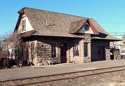 |
February 28, 1985 (#85000357) |
East and 3rd Sts. 41°29′12″N 120°32′23″W / 41.486726°N 120.539791°W |
Alturas | |
| 11 | Nelson Springs | November 21, 2002 (#02001393) |
Address Restricted |
Likely | ||
| 12 | Nevada-California-Oregon Railway Co. General Office Building | 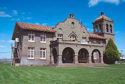 |
September 6, 1974 (#74000529) |
619 N. Main St. 41°29′23″N 120°32′35″W / 41.489632°N 120.543015°W |
Alturas | |
| 13 | Petroglyph Point Archeological Site | 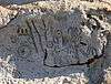 |
May 29, 1975 (#75000178) |
Address Restricted |
Tulelake | |
| 14 | Sacred Heart Catholic Church | 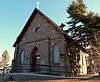 |
June 30, 1983 (#83001209) |
507 E. 4th St. 41°29′14″N 120°32′13″W / 41.487241°N 120.536883°W |
Alturas | |
| 15 | Seven Mile Flat Site | December 24, 1974 (#74000340) |
Address Restricted |
Devil's Garden Ranger District | ||
| 16 | Skull Ridge | July 9, 1974 (#74000287) |
Address Restricted |
Canby | ||
| 17 | Skull Spring | July 9, 1974 (#74000288) |
Address Restricted |
Canby | ||
| 18 | Tule Lake Segregation Center | February 17, 2006 (#06000210) |
NE side CA 139 41°53′07″N 121°22′29″W / 41.885347°N 121.374833°W |
Newell |
See also
| Wikimedia Commons has media related to National Register of Historic Places in Modoc County, California. |
References
- ↑ The latitude and longitude information provided in this table was derived originally from the National Register Information System, which has been found to be fairly accurate for about 99% of listings. For about 1% of NRIS original coordinates, experience has shown that one or both coordinates are typos or otherwise extremely far off; some corrections may have been made. A more subtle problem causes many locations to be off by up to 150 yards, depending on location in the country: most NRIS coordinates were derived from tracing out latitude and longitudes from USGS topographical quadrant maps created under the North American Datum of 1927, which differs from the current, highly accurate WGS84 GPS system used by most on-line maps. Chicago is about right, but NRIS longitudes in Washington are higher by about 4.5 seconds, and are lower by about 2.0 seconds in Maine. Latitudes differ by about 1.0 second in Florida. Some locations in this table may have been corrected to current GPS standards.
- ↑ "National Register of Historic Places: Weekly List Actions". National Park Service, United States Department of the Interior. Retrieved on October 4, 2018.
- ↑ Numbers represent an ordering by significant words. Various colorings, defined here, differentiate National Historic Landmarks and historic districts from other NRHP buildings, structures, sites or objects.
- ↑ National Park Service (2010-07-09). "National Register Information System". National Register of Historic Places. National Park Service.
- ↑ The eight-digit number below each date is the number assigned to each location in the National Register Information System database, which can be viewed by clicking the number.
| Topics | |
|---|---|
| Lists by states |
|
| Lists by insular areas | |
| Lists by associated states | |
| Other areas | |
| |
This article is issued from
Wikipedia.
The text is licensed under Creative Commons - Attribution - Sharealike.
Additional terms may apply for the media files.