| [3] |
Name on the Register[4] |
Image |
Date listed[5] |
Location |
City or town |
Description |
|---|
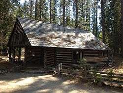
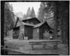
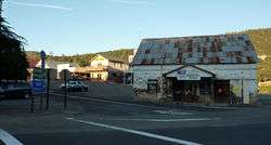
| 1 |
Acting Superintendent's Headquarters |
|
June 9, 1978
(#78000362) |
Yosemite National Park
37°32′20″N 119°39′17″W / 37.538889°N 119.654722°W / 37.538889; -119.654722 (Acting Superintendent's Headquarters) |
Wawona |
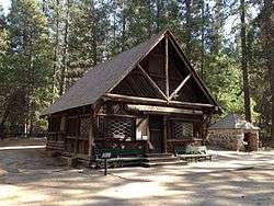
|
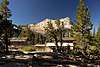
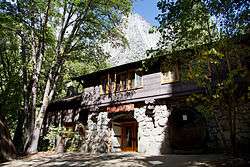
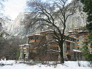
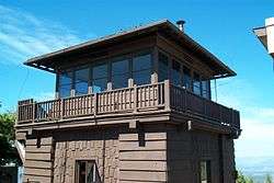
| 2 |
Ahwahnee Hotel |
|
February 15, 1977
(#77000149) |
Yosemite Valley
37°44′45″N 119°34′22″W / 37.745833°N 119.572778°W / 37.745833; -119.572778 (Ahwahnee Hotel) |
Yosemite National Park |
|
| 3 |
Bagby Stationhouse, Water Tanks and Turntable |
|
April 13, 1979
(#79000316) |
CA 140
37°40′27″N 119°46′47″W / 37.674167°N 119.779722°W / 37.674167; -119.779722 (Bagby Stationhouse, Water Tanks and Turntable) |
El Portal |
|
| 4 |
Big Gap Flume |
|
May 12, 1975
(#75000438) |
East of Groveland off CA 120 in Stanislaus National Forest
37°49′19″N 120°03′34″W / 37.821944°N 120.059444°W / 37.821944; -120.059444 (Big Gap Flume) |
Groveland |
|
| 5 |
Bower Cave |
|
June 16, 2003
(#01000719) |
Address Restricted
|
Greeley Hill |
|
| 6 |
Camp 4 |
|
February 21, 2003
(#03000056) |
Northside Dr., Yosemite National Park
37°44′30″N 119°36′09″W / 37.741667°N 119.6025°W / 37.741667; -119.6025 (Camp 4) |
Yosemite |
|
| 7 |
Camp Curry Historic District |
|
November 1, 1979
(#79000315) |
Yosemite Valley
37°44′36″N 119°34′16″W / 37.743333°N 119.571111°W / 37.743333; -119.571111 (Camp Curry Historic District) |
Yosemite National Park |
|
| 8 |
Coulterville Main Street Historic District |
|
March 12, 1982
(#82002205) |
Main St.
37°42′38″N 120°11′50″W / 37.710556°N 120.197222°W / 37.710556; -120.197222 (Coulterville Main Street Historic District) |
Coulterville |
|
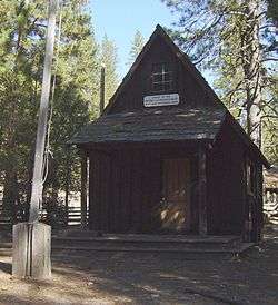
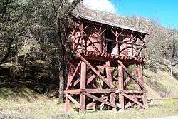
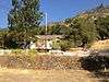
| 9 |
Crane Flat Fire Lookout |
|
April 4, 1996
(#96000354) |
North of Big Oak Flat Rd., near Crane Cr., Yosemite National Park
37°45′34″N 119°49′10″W / 37.759444°N 119.819444°W / 37.759444; -119.819444 (Crane Flat Fire Lookout) |
Aspen Valley |
part of the Historic Park Landscapes in National and State Parks Multiple Property Submission (MPS) |
| 10 |
Degnan's Restaurant |
|
September 5, 2017
(#100001558) |
9001 Village Dr.
37°44′53″N 119°35′08″W / 37.748079°N 119.585526°W / 37.748079; -119.585526 (Degnan's Restaurant) |
Yosemite National Park |
|
| 11 |
El Portal Archeological District |
|
August 18, 1978
(#78000359) |
Address Restricted
|
Mariposa |
|
| 12 |
El Portal Old Schoolhouse |
|
February 1, 2011
(#10001190) |
Chapel Lane, Yosemite National Park
37°40′29″N 119°47′11″W / 37.674722°N 119.786389°W / 37.674722; -119.786389 (El Portal Old Schoolhouse) |
El Portal |
|
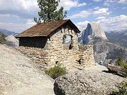
| 13 |
Glacier Point Trailside Museum |
|
April 4, 1978
(#78000357) |
East of El Portal in Yosemite National Park
37°43′50″N 119°34′23″W / 37.730556°N 119.573056°W / 37.730556; -119.573056 (Glacier Point Trailside Museum) |
El Portal |
|
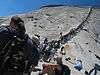
| 14 |
Half Dome Cables and Trail |
|
August 15, 2012
(#12000494) |
P.O. Box 577
37°44′49″N 119°31′47″W / 37.746863°N 119.529669°W / 37.746863; -119.529669 (Half Dome Cables and Trail) |
Yosemite |
|
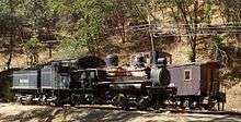
| 15 |
Hetch Hetchy Railroad Engine No.6 |
|
January 30, 1978
(#78000360) |
CA 140
37°40′30″N 119°46′46″W / 37.675°N 119.779444°W / 37.675; -119.779444 (Hetch Hetchy Railroad Engine No.6) |
El Portal |
|
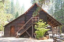
| 16 |
Hodgdon Homestead Cabin |
|
June 9, 1978
(#78000356) |
Yosemite National Park
37°32′20″N 119°39′19″W / 37.538889°N 119.655278°W / 37.538889; -119.655278 (Hodgdon Homestead Cabin) |
Wawona |
|
| 17 |
Hornitos Masonic Hall No. 98 |
|
August 3, 2005
(#05000775) |
2877 Bear Valley Rd.
37°30′05″N 120°14′14″W / 37.501389°N 120.237222°W / 37.501389; -120.237222 (Hornitos Masonic Hall No. 98) |
Hornitos |
|
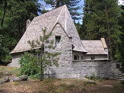
| 18 |
Chris Jorgenson Studio |
|
April 13, 1979
(#79000280) |
Pioneer Yosemite Historic Center
37°32′20″N 119°39′19″W / 37.538889°N 119.655278°W / 37.538889; -119.655278 (Chris Jorgenson Studio) |
Yosemite National Park |
|
| 19 |
LeConte Memorial Lodge |
|
March 8, 1977
(#77000148) |
Yosemite Valley, Yosemite National Park
37°44′24″N 119°34′42″W / 37.74°N 119.578333°W / 37.74; -119.578333 (LeConte Memorial Lodge) |
Curry Village |
|
| 20 |
Mariposa County Courthouse |
|
December 7, 1977
(#77000306) |
5088 Bullion St.
37°29′20″N 119°57′59″W / 37.488889°N 119.966389°W / 37.488889; -119.966389 (Mariposa County Courthouse) |
Mariposa |
|
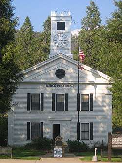
| 21 |
Mariposa County High School Auditorium |
|
May 2, 1991
(#91000547) |
5074 Old Highway N.
37°29′21″N 119°57′47″W / 37.489167°N 119.963056°W / 37.489167; -119.963056 (Mariposa County High School Auditorium) |
Mariposa |
|
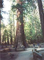
| 22 |
Mariposa Grove Museum |
|
December 1, 1978
(#78000381) |
Southeast of Wawona in Yosemite National Park
37°30′50″N 119°35′54″W / 37.513889°N 119.598333°W / 37.513889; -119.598333 (Mariposa Grove Museum) |
Wawona |
|
| 23 |
Mariposa Town Historic District |
|
May 15, 1991
(#91000560) |
Roughly bounded by Charles, 11th, Jones and 4th Sts.
37°29′14″N 119°57′54″W / 37.487222°N 119.965°W / 37.487222; -119.965 (Mariposa Town Historic District) |
Mariposa |
|
| 24 |
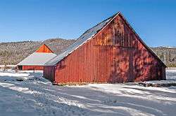
McCauley and Meyer Barns |
|
June 15, 1978
(#78000353) |
North of El Portal in Yosemite National Park
37°42′00″N 119°45′18″W / 37.7°N 119.755°W / 37.7; -119.755 (McCauley and Meyer Barns) |
El Portal |
|
| 25 |
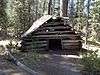
McGurk Cabin |
|
June 4, 1979
(#79000281) |
South of Yosemite Village
37°40′40″N 119°37′27″W / 37.677778°N 119.624167°W / 37.677778; -119.624167 (McGurk Cabin) |
Yosemite Village |
|
| 26 |
Merced Grove Ranger Station |
|
June 15, 1978
(#78000358) |
North of El Portal in Yosemite National Park
37°44′56″N 119°50′21″W / 37.748889°N 119.839167°W / 37.748889; -119.839167 (Merced Grove Ranger Station) |
El Portal |
|
| 27 |
Merced Lake High Sierra Camp |
|
July 18, 2014
(#14000407) |
Along North bank of Merced River, directly East of Merced Lake
37°44′24″N 119°24′24″W / 37.739928°N 119.406544°W / 37.739928; -119.406544 (Merced Lake High Sierra Camp) |
Yosemite |
|
| 28 |
Merced Lake Ranger Station |
|
July 18, 2014
(#14000408) |
Jct. of Merced Lake Tr. & Lewis Cr.
37°44′18″N 119°23′45″W / 37.738261°N 119.395709°W / 37.738261; -119.395709 (Merced Lake Ranger Station) |
Yosemite |
|
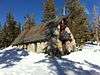
| 29 |
Ostrander Lake Ski Hut |
|
July 18, 2014
(#14000409) |
Ostrander Lake Tr.
37°37′36″N 119°32′59″W / 37.626778°N 119.549753°W / 37.626778; -119.549753 (Ostrander Lake Ski Hut) |
Yosemite |
|
| 30 |
Rangers' Club |
|
May 28, 1987
(#87001414) |
Yosemite Valley
37°44′50″N 119°35′12″W / 37.747222°N 119.586667°W / 37.747222; -119.586667 (Rangers' Club) |
Yosemite National Park |
|
| 31 |
St. Joseph Catholic Church, Rectory and Cemetery |
|
April 16, 1991
(#91000424) |
4983-4985 Bullion St.
37°28′57″N 119°57′37″W / 37.4825°N 119.960278°W / 37.4825; -119.960278 (St. Joseph Catholic Church, Rectory and Cemetery) |
Mariposa |
|
| 32 |
Snow Creek Ski Hut |
|
July 18, 2014
(#14000410) |
Off Tanaya Lake Trail, westerly shoulder of Mt. Watkins
37°47′17″N 119°31′22″W / 37.787980°N 119.522663°W / 37.787980; -119.522663 (Snow Creek Ski Hut) |
Yosemite |
|
| 33 |
Snow Flat Snow Survey Shelter |
|
July 18, 2014
(#14000411) |
Terminus of service road off May Lake Rd.
37°49′31″N 119°29′52″W / 37.825332°N 119.497667°W / 37.825332; -119.497667 (Snow Flat Snow Survey Shelter) |
Yosemite |
|
| 34 |
Sunrise High Sierra Camp |
|
July 18, 2014
(#14000412) |
Along North bank of Long Meadow Creek, overlooking Long Meadow (southeast of Sunrise Lakes)
37°47′43″N 119°25′58″W / 37.795203°N 119.432658°W / 37.795203; -119.432658 (Sunrise High Sierra Camp) |
Yosemite |
|
| 35 |
Track Bus No. 19 |
|
May 22, 1978
(#78000363) |
CA 140
37°40′30″N 119°46′46″W / 37.675°N 119.779444°W / 37.675; -119.779444 (Track Bus No. 19) |
El Portal |
|
| 36 |
Vogelsang High Sierra Camp |
|
July 18, 2014
(#14000413) |
Along Fletcher Creek, immediately southwest of Fletcher Lake
37°47′43″N 119°20′44″W / 37.795205°N 119.345431°W / 37.795205; -119.345431 (Vogelsang High Sierra Camp) |
Yosemite |
|
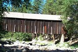
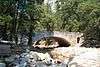
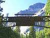
| 37 |
Wawona Covered Bridge |
|
January 11, 2007
(#06001261) |
Pioneer Yosemite History Center
37°32′19″N 119°39′17″W / 37.538611°N 119.654722°W / 37.538611; -119.654722 (Wawona Covered Bridge) |
Wawona |
|
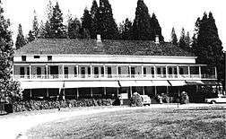
| 38 |
Wawona Hotel and Pavilion |
|
October 1, 1975
(#75000223) |
On CA 41 in Yosemite National Park
37°32′11″N 119°39′13″W / 37.536389°N 119.653611°W / 37.536389; -119.653611 (Wawona Hotel and Pavilion) |
Wawona |
|
| 39 |
Yosemite Transportation Company Office |
|
June 9, 1978
(#78000355) |
North of Wawona in Yosemite National Park
37°32′20″N 119°39′17″W / 37.538889°N 119.654722°W / 37.538889; -119.654722 (Yosemite Transportation Company Office) |
Wawona |
|
| 40 |
Yosemite Valley Archeological District |
|
January 20, 1978
(#78000361) |
Address Restricted
|
Yosemite Village |
|
| 41 |
Yosemite Valley Bridges |
|
November 25, 1977
(#77000160) |
8 Bridges over Merced River, Yosemite National Park
37°43′58″N 119°36′00″W / 37.732778°N 119.6°W / 37.732778; -119.6 (Yosemite Valley Bridges) |
Yosemite Village |
|
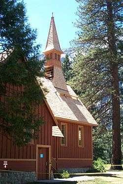
| 42 |
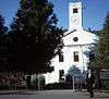
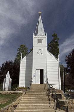
Yosemite Valley Chapel |
|
December 12, 1973
(#73000256) |
Off CA 140
37°44′27″N 119°35′26″W / 37.740833°N 119.590556°W / 37.740833; -119.590556 (Yosemite Valley Chapel) |
Yosemite National Park |
|
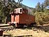
| 43 |
Yosemite Valley Railroad Caboose No. 15 |
|
May 22, 1978
(#78000352) |
CA 140
37°40′30″N 119°46′46″W / 37.675°N 119.779444°W / 37.675; -119.779444 (Yosemite Valley Railroad Caboose No. 15) |
El Portal |
|
| 44 |
Yosemite Village Historic District |
|
March 30, 1978
(#78000354) |
East of El Portal in Yosemite National Park
37°44′55″N 119°35′18″W / 37.748611°N 119.588333°W / 37.748611; -119.588333 (Yosemite Village Historic District) |
El Portal |
|
.jpg)