Valcivières
| Valcivières | |
|---|---|
| Commune | |
 Valcivières | |
 Valcivières Location within Auvergne-Rhône-Alpes region  Valcivières | |
| Coordinates: 45°35′34″N 3°47′47″E / 45.5928°N 3.7964°ECoordinates: 45°35′34″N 3°47′47″E / 45.5928°N 3.7964°E | |
| Country | France |
| Region | Auvergne-Rhône-Alpes |
| Department | Puy-de-Dôme |
| Arrondissement | Ambert |
| Canton | Ambert |
| Intercommunality | Pays d'Ambert |
| Government | |
| • Mayor (2005–2008) | André Voldoire |
| Area1 | 32.96 km2 (12.73 sq mi) |
| Population (2006)2 | 219 |
| • Density | 6.6/km2 (17/sq mi) |
| Demonym(s) | Cheveyrand |
| Time zone | UTC+1 (CET) |
| • Summer (DST) | UTC+2 (CEST) |
| INSEE/Postal code | 63441 /63600 |
| Elevation | 651–1,556 m (2,136–5,105 ft) |
|
1 French Land Register data, which excludes lakes, ponds, glaciers > 1 km2 (0.386 sq mi or 247 acres) and river estuaries. 2 Population without double counting: residents of multiple communes (e.g., students and military personnel) only counted once. | |
Valcivières is a commune in the Puy-de-Dôme department in Auvergne in central France.
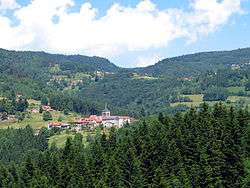
The village.
See also
References
| Wikimedia Commons has media related to Valcivières. |
This article is issued from
Wikipedia.
The text is licensed under Creative Commons - Attribution - Sharealike.
Additional terms may apply for the media files.