Paslières
| Puy-guillaume | |
|---|---|
| Commune | |
 Puy-guillaume Location within Auvergne-Rhône-Alpes region  Puy-guillaume | |
| Coordinates: 45°55′44″N 3°29′53″E / 45.929°N 3.498°ECoordinates: 45°55′44″N 3°29′53″E / 45.929°N 3.498°E | |
| Country | France |
| Region | Auvergne-Rhône-Alpes |
| Department | Puy-de-Dôme |
| Arrondissement | Thiers |
| Canton | Maringues |
| Government | |
| • Mayor | Roland Virlogeux |
| Area1 | 27.77 km2 (10.72 sq mi) |
| Population (2006)2 | 1,525 |
| • Density | 55/km2 (140/sq mi) |
| Time zone | UTC+1 (CET) |
| • Summer (DST) | UTC+2 (CEST) |
| INSEE/Postal code | 63271 /63290 |
| Elevation |
275–800 m (902–2,625 ft) (avg. 420 m or 1,380 ft) |
|
1 French Land Register data, which excludes lakes, ponds, glaciers > 1 km2 (0.386 sq mi or 247 acres) and river estuaries. 2 Population without double counting: residents of multiple communes (e.g., students and military personnel) only counted once. | |
Paslières is a commune in the Puy-de-Dôme department in Auvergne in central France.
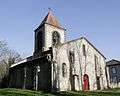 Saint-Bonnet church, hamlet of Croix Saint-Bonnet
See also
References
| Wikimedia Commons has media related to Paslières. |
This article is issued from
Wikipedia.
The text is licensed under Creative Commons - Attribution - Sharealike.
Additional terms may apply for the media files.