Le Vernet-Sainte-Marguerite
| Le Vernet-Sainte-Marguerite | |
|---|---|
| Commune | |
 Le Vernet-Sainte-Marguerite Location within Auvergne-Rhône-Alpes region  Le Vernet-Sainte-Marguerite | |
| Coordinates: 45°36′36″N 2°56′53″E / 45.610°N 2.948°ECoordinates: 45°36′36″N 2°56′53″E / 45.610°N 2.948°E | |
| Country | France |
| Region | Auvergne-Rhône-Alpes |
| Department | Puy-de-Dôme |
| Arrondissement | Issoire |
| Canton | Orcines |
| Intercommunality | Les Cheires |
| Area1 | 25.03 km2 (9.66 sq mi) |
| Population (2006)2 | 255 |
| • Density | 10/km2 (26/sq mi) |
| Time zone | UTC+1 (CET) |
| • Summer (DST) | UTC+2 (CEST) |
| INSEE/Postal code | 63449 /63710 |
| Elevation |
869–1,363 m (2,851–4,472 ft) (avg. 1 m or 3.3 ft) |
|
1 French Land Register data, which excludes lakes, ponds, glaciers > 1 km2 (0.386 sq mi or 247 acres) and river estuaries. 2 Population without double counting: residents of multiple communes (e.g., students and military personnel) only counted once. | |
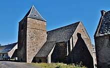
Church
Le Vernet-Sainte-Marguerite is a commune in the Puy-de-Dôme department in Auvergne in central France.
Notable people
- Mathieu de Combarel de Leyval (1808–69), member of the National Assembly during the July Monarchy and the French Second Republic.[1]
See also
References
- ↑ Mathieu, Louis, Désiré de Combarel de Leyval (in French), Assemblée nationale, retrieved 2018-07-11
| Wikimedia Commons has media related to Le Vernet-Sainte-Marguerite. |
This article is issued from
Wikipedia.
The text is licensed under Creative Commons - Attribution - Sharealike.
Additional terms may apply for the media files.