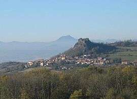
Yronde-et-Buron
| Yronde-et-Buron | |
|---|---|
| Commune | |
 | |
 Yronde-et-Buron Location within Auvergne-Rhône-Alpes region  Yronde-et-Buron | |
| Coordinates: 45°36′47″N 3°15′18″E / 45.613°N 3.255°ECoordinates: 45°36′47″N 3°15′18″E / 45.613°N 3.255°E | |
| Country | France |
| Region | Auvergne-Rhône-Alpes |
| Department | Puy-de-Dôme |
| Arrondissement | Clermont-Ferrand |
| Canton | Vic-le-Comte |
| Intercommunality | Mond'Arverne Communauté |
| Government | |
| • Mayor (2014-2020) | Yves Pradier |
| Area1 | 14.79 km2 (5.71 sq mi) |
| Population (2014)2 | 673 |
| • Density | 46/km2 (120/sq mi) |
| Time zone | UTC+1 (CET) |
| • Summer (DST) | UTC+2 (CEST) |
| INSEE/Postal code | 63472 /63270 |
| Elevation |
344–824 m (1,129–2,703 ft) (avg. 520 m or 1,710 ft) |
|
1 French Land Register data, which excludes lakes, ponds, glaciers > 1 km2 (0.386 sq mi or 247 acres) and river estuaries. 2 Population without double counting: residents of multiple communes (e.g., students and military personnel) only counted once. | |
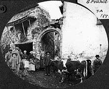
Buron in 1885
Yronde-et-Buron is a commune in the Puy-de-Dôme department in Auvergne in central France.
See also
References
| Wikimedia Commons has media related to Yronde-et-Buron. |
This article is issued from
Wikipedia.
The text is licensed under Creative Commons - Attribution - Sharealike.
Additional terms may apply for the media files.