Urbana, Maryland
| Urbana, Maryland | |
|---|---|
| Census-designated place | |
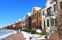 Rowhouses along Worthington Boulevard | |
 Urbana Location in Maryland  Urbana Urbana (the US) | |
| Coordinates: 39°19′33″N 77°21′05″W / 39.32583°N 77.35139°WCoordinates: 39°19′33″N 77°21′05″W / 39.32583°N 77.35139°W | |
| Country |
|
| State |
|
| County |
|
| Area | |
| • Total | 6.62 sq mi (17.15 km2) |
| • Land | 6.56 sq mi (16.99 km2) |
| • Water | 0.06 sq mi (0.16 km2) |
| Elevation | 468 ft (143 m) |
| Population (2010) | |
| • Total | 9,175 |
| • Density | 1,399/sq mi (540.1/km2) |
| Time zone | UTC−5 (Eastern (EST)) |
| • Summer (DST) | UTC−4 (EDT) |
| ZIP code | 21704 |
| Area code(s) | 240 |
| FIPS code | 24-79900 |
| GNIS feature ID | 0583799 |
Urbana (/ərˈbænə/ ər-BAN-ə) is a suburban census-designated place located in Frederick County, Maryland, United States. It lies at the I-270/MD 80 interchange, about 7.5 miles (12.1 km) southeast of Frederick and about 37 miles (60 km) northwest of Washington, D.C. Urbana started to develop around 1999 and as of the 2010 census had a population of 9,175.[1] It is part of the Washington metropolitan area.
In August 2015, Urbana was ranked #35 in the country for Time magazine's "Best Places to Live 2015".[2]
In 2018, Urbana was ranked #9 in maryland for Niche's Best places to live 2018[3]
History
18th, 19th, and 20th centuries
The Urbana area was first settled in 1730.[4]
Urbana is the site of Landon House, which was built in 1754 along the Rappahannock River around Fredericksburg, Virginia. It was used as a seminary for girls.[5] In 1840, Landon House was moved by boat to Washington and then by oxcarts to its present site in Urbana.[5] Landon House later served as a military academy and a hospital during the Civil War.[6] Confederate General J.E.B. Stuart's officers held a dance at Landon House in 1862.[5] During the dance, Union cavalry advanced on the house, but the Confederate military drove the Union forces away and the dance continued.[5]
Zion Episcopal Church was built in 1802 and served as a house of worship until badly damaged by fire in 1961. Since 2005, it is being restored to its original condition for use as a museum.[7] Amelung House and Glassworks was listed on the National Register of Historic Places in 1973.[8] Stancioff House was listed in 1975 and Fat Oxen in 1979.[8]
2000–2010
The original Urbana community has been somewhat overshadowed by more recent developments, such as the Villages of Urbana and the Urbana Highlands. These developments (begun in 1999) have swelled Urbana's population and put strain on the community's school system, police force, and utilities.
In 2006, the Urbana Regional Library and Senior Center opened on Amelung Street. The facility includes three floors and over 25,000 square feet (2,300 m2).[9]
Urbana has some of the highest quality ratings for elementary, middle, and high schools in Maryland. The population is very diverse and was named "The 2009 Best Selling Community in Maryland".[10] The community has three swimming pools, a new district park, plenty of tennis and basketball courts and is close to the I-270 technology corridor.
2010–present
As of the 2010 census, Urbana had a population of 9,175 people, an increase from 622 residents in 2000. Urbana has also gained a few more shops and restaurants such as "Manhattan Pizza" which started and finished construction from 2016 to 2018. Urbana is starting to have plans to destroy the old elementary school between 2018 and 2019. New townhouses were built near the high school.
Fannie Mae data center and Legal & General America are headquartered in Urbana. The US Social Security Administration data center is located in Urbana
Geography

Urbana is located in southeastern Frederick County, centered at the intersection of Maryland Routes 80 and 355. Interstate 270 forms the southwestern edge of the community, with access from Exit 26 (MD 80).
According to the U.S. Census Bureau, the Urbana CDP has a total area of 6.6 square miles (17.2 km2), of which 6.6 square miles (17.0 km2) is land and 0.1 square miles (0.2 km2), or 0.95%, is water.[1]
Climate
Urbana is part of the Humid subtropical climate zone, with hot, humid summers, cool winters, and generous precipitation year-round. It is above the Fall Line,which in turn, gives it slightly lower year-round temperatures than cities to the south, such as Washington, D.C.
On average, Urbana gets about 40 inches (1,000 mm) of rain (April and May being the 2 rainiest months on average with 9 days of rain each) and25 inches (640 mm) of snow per year. July is the warmest month, with an average high of around 87 °F (31 °C).
The coldest month is January, with an average low of around 23 °F (−5 °C). Urbana experienced rain 108 days of the year.[12]
Recreation
Urbana offers many walking trails and small parks throughout the villages, making it possible to go almost anywhere in the town completely by foot. Also, Urbana offers basketball courts, tennis courts, and dozens of smaller parks and small bench areas in almost every neighborhood. The primary recreational facilities in Urbana are:
Urbana District Park
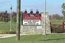
Finished in 2012, the Urbana District Park is a new, 95-acre (38 ha) park. The park is located near the intersection of Md. Route 355 and Lew Wallace Street. This fulfills an early promise by Villages of Urbana developer Tom Natelli, who dedicated the land for the park in 2004.[14] The goal of the first phase of new development of Urbana District Park was to provide athletic facilities, as well as several passive recreational amenities for the southern region of Frederick County, which was lacking in open sports fields. The $5.9 million Phase I construction included two multipurpose fields, one football/lacrosse field, one baseball field, one softball field, one little league field, a new entrance drive, parking, walking/ biking trails, water and electric utilities, restrooms, picnic pavilions, playground, park maintenance facility, landscaping/reforestation and various site amenities. Three parking lots create a total of 466 spaces. One of the most convenient features of the park is that its walking trails connect to the main Villages of Urbana walking trails, meaning you could travel along the walking trails from within Urbana and go straight to the park without having to leave the trail. After 2012 many more baseball fields have been added to a total of 5 baseball fields and a soccer field.
Shafer's Mill Recreation Center
Shafer's Mill is home one of two limited-access pools and fitness centers within the Villages of Urbana. This is the second pool, located at 9228 Shafers Mill Dr, in the new Urbana district. The Shafer's Mill Recreation Center includes a fitness center for Association members, as well as a community room that is available for community groups, events and classes.
Anthony Natelli Community Center
The Anthony Natelli Community Center is located On Harris St, inside of the Villages of Urbana. Facilities include a large swimming pool complex, meeting rooms and community event facilities. In addition, the center has four tennis courts and a basketball court and a pool that includes a recreational and lap pool (both of which are outdoors). The Anthony Natelli Community Center hosts numerous recreation and fitness programs, board and committee meetings, and is available for rent.
Urbana Community Park
The oldest park of the original Urbana community, much of its use has been overshadowed by the new Urbana District Park and the recent Sugarloaf Elementary School construction. The park features two playgrounds, tennis courts, and multiple baseball fields.
Economy

As of 2016, Urbana is home to the Fannie Mae Data Center and is the current headquarters for Legal & General America.
Fannie Mae regional data center was the first building constructed in the Urbana Corporate Center. Built in 2004, the facility is a 220,000 sq. ft. state of the art office and data center facility with 90,000 sq. ft. of office space, a 60,000 sq. ft. data center, and a 70,000 sq. ft. MEP facility. The Fannie Mae Data center was one of the first data centers in the country to receive LEED certification which included sediment control and stormwater management credits.[15]
Demographics
As of the 2010 U.S. Census,[16] there were 9,175 people and 2,804 households residing in the Urbana census-designated place. The population density was 1,411.5 people per square mile (545.2/km²). Ethnically, the population is made up of 66.7% White, 9.0% African-American,.3% American Indian or Alaska Native, 17.5% Asian, .0% Native Hawaiian or Pacific Islander, 4.1% of two or more races, and 10.1% Hispanic or Latino of any race.
Government
Despite all the rapid development, Urbana has not been incorporated as a town or a city. It has no official mayor or city council and is governed by Frederick County. It is represented by Republican Tony Chmelik in the Frederick County regional council.
Schools
Public schools in Urbana are part of the Frederick County Public Schools (Maryland) system.
- Urbana High School has been recognized as one of Maryland's top 25 engineering schools by the A. James Clark School of Engineering of The University of Maryland. In addition, UHS has been named one of America's Top High Schools in Newsweek's 2015 High School Rankings. Urbana also ranks #1 in students taking AP exams (509), number of AP exams taken (979), percent of Total AP Students Scoring 3+ (77% - 392), and AP Mean Score 3.37.
 An aerial view of Urbana High School
 - Urbana Middle School
- Urbana Elementary School is one of three magnet schools in Frederick County.
- Centerville Elementary School
Major roads
Culture
Events
- Centerville Elementary School holds a star-spangled celebration and Urbana Elementary holds a strawberry festival. The Urbana Volunteer Fire Department's Carnival takes place in mid-July. Numerous smaller celebrations are held at the local pool and community center.
References
- 1 2 "Geographic Identifiers: 2010 Census Summary File 1 (G001), Urbana CDP, Maryland". American FactFinder. U.S. Census Bureau. Retrieved June 2, 2016.
- ↑ "Best Places to Live 2015: Urbana, Maryland". MONEY.com. Retrieved 2016-04-02.
- ↑ "2018 Urbana Best Places Rankings". Niche. Retrieved 2018-03-27.
- ↑ culture/timeline.htm Timeline of the Monocacy River area
- 1 2 3 4 Maryland Writer's Project, Works Project Administration. Maryland: A Guide to the Old Line State. Oxford University Press. August 1940. p. 511.
- ↑ "About". Landon House.
- ↑ frederickcountylandmarksfoundation.org
- 1 2 National Park Service (2008-04-15). "National Register Information System". National Register of Historic Places. National Park Service.
- ↑ fcpl.org
- ↑ "Villages of Urbana". www.villagesofurbana.com. Retrieved 14 August 2017.
- ↑ "Maps". www.bing.com. Retrieved 2016-04-13.
- ↑ "Urbana, Maryland Climate". www.bestplaces.net. Retrieved 2016-04-02.
- 1 2 "Urbana, MD - An Eclectic Town". Housewives. Retrieved 2016-04-03.
- ↑ "District Park Construction Underway | Town Courier Urbana". towncourier.com. Retrieved 2016-04-03.
- ↑ "Fannie Mae Data Center | Rodgers Consulting". www.rodgers.com. Retrieved 2016-04-05.
- ↑ "American FactFinder". United States Census Bureau. Retrieved 2008-01-31.
External links
- Urbana, Maryland at Curlie (based on DMOZ)
- Urbana website/forum
Municipalities and communities of Frederick County, Maryland, United States | ||
|---|---|---|
| Cities | 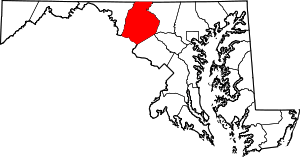 | |
| Towns | ||
| Village | ||
| CDPs | ||
| Other communities |
| |
| Footnotes | ‡This populated place also has portions in an adjacent county or counties | |