Garfield, Maryland
| Garfield, Maryland | |
|---|---|
| Unincorporated community | |
 Garfield Location in Maryland | |
| Coordinates: 39°36′14″N 077°31′19″W / 39.60389°N 77.52194°WCoordinates: 39°36′14″N 077°31′19″W / 39.60389°N 77.52194°W | |
| Country | United States |
| State | Maryland |
| County | Frederick |
| Elevation[1] | 1,453 ft (443 m) |
| Time zone | UTC-5 (Eastern (EST)) |
| • Summer (DST) | UTC-4 (EDT) |
| FIPS code | 04-31450 |
| GNIS feature ID | 590278 |
Garfield is an unincorporated community in Frederick County, Maryland, United States, situated within the District 6, Catoctin. It has an elevation of 1,453 feet (443 m).
Garfield appears on the Myersville U.S. Geological Survey Map and is located in the Eastern Time Zone.[2]
Garfield United Methodist Church
One of the few structures in Garfield is the Garfield United Methodist Church. It is relatively small and is located on Stottlemeyer Road.[3]
References
- ↑ "Feature Detail Report for: Garfield". Geographic Names Information System. United States Geological Survey.
- ↑ "Garfield Populated Place Profile / Frederick County, Maryland Data". maryland.hometownlocator.com. Retrieved 2016-01-24.
- ↑ "Garfield United Methodist Chr in Smithsburg , MD". YP.com. Retrieved 2016-01-24.
Municipalities and communities of Frederick County, Maryland, United States | ||
|---|---|---|
| Cities | 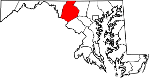 | |
| Towns | ||
| Village | ||
| CDPs | ||
| Other communities |
| |
| Footnotes | ‡This populated place also has portions in an adjacent county or counties | |
This article is issued from
Wikipedia.
The text is licensed under Creative Commons - Attribution - Sharealike.
Additional terms may apply for the media files.