Two Medicine River
| Two Medicine River | |
|---|---|
.jpg) | |
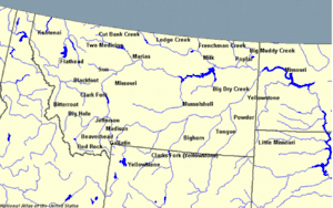 Montana rivers with Two Medicine in the north central | |
| Country | Pondera and Glacier County, Montana |
| Physical characteristics | |
| Main source | 48°29′32″N 113°15′49″W / 48.49222°N 113.26361°W[1] |
| River mouth |
3,294 feet (1,004 m)[1] 48°29′11″N 112°13′40″W / 48.48639°N 112.22778°WCoordinates: 48°29′11″N 112°13′40″W / 48.48639°N 112.22778°W[1] |
| Basin features | |
| River system | Missouri River |
The Two Medicine River is a tributary of the Marias River, approximately 60 mi (97 km) long, in northwestern Montana in the United States.
It rises in the Rocky Mountain Front in Glacier National Park at the continental divide and flows east, down from the mountains and across the Blackfeet Indian Reservation. It receives Birch Creek in southeastern Glacier County and joins Cut Bank Creek to form the Marias, approximately 12 mi (19 km) southeast of Cut Bank.
See also
Notes

This article is issued from
Wikipedia.
The text is licensed under Creative Commons - Attribution - Sharealike.
Additional terms may apply for the media files.