Tracy, New Jersey
| Tracy, New Jersey | |
|---|---|
| Unincorporated community | |
 Along Federal Road | |
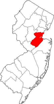
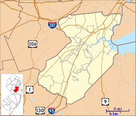 Tracy, New Jersey Location of Tracy in Middlesex County Inset: Location of county within the state of New Jersey  Tracy, New Jersey Tracy, New Jersey (New Jersey)  Tracy, New Jersey Tracy, New Jersey (the US) | |
| Coordinates: 40°18′10″N 74°23′01″W / 40.30278°N 74.38361°WCoordinates: 40°18′10″N 74°23′01″W / 40.30278°N 74.38361°W | |
| Country |
|
| State |
|
| County | Middlesex |
| Township | Monroe |
| Elevation[1] | 82 ft (25 m) |
| GNIS feature ID | 881232[1] |
Tracy is an unincorporated community located within Monroe Township in Middlesex County, New Jersey, United States.[2] The settlement is located at the site of a former station on the Freehold and Jamesburg Agricultural Railroad in the southeastern edge of the township.[3] Most of the area is forestland with some homes and light commercial businesses located along Federal Road and Tracy Station Road.[4]
References
- 1 2 "Tracy". Geographic Names Information System. United States Geological Survey.
- ↑ Locality Search, State of New Jersey. Accessed February 15, 2015.
- ↑ Pennsylvania Railroad and its connections (Map). Philadelphia: Allen, Lane, and Scott. December 1, 1911. Retrieved November 22, 2015.
- ↑ Google (November 22, 2015). "Aerial view of Tracy" (Map). Google Maps. Google. Retrieved November 22, 2015.
This article is issued from
Wikipedia.
The text is licensed under Creative Commons - Attribution - Sharealike.
Additional terms may apply for the media files.