Bonhamtown, New Jersey
| Bonhamtown, New Jersey | |
|---|---|
| Unincorporated community | |
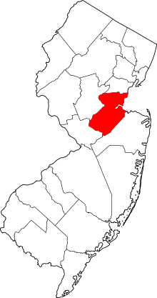
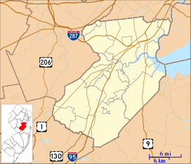 Bonhamtown, New Jersey Location of Bonhamtown in Middlesex County Inset: Location of county within the state of New Jersey  Bonhamtown, New Jersey Bonhamtown, New Jersey (New Jersey)  Bonhamtown, New Jersey Bonhamtown, New Jersey (the US) | |
| Coordinates: 40°31′24″N 74°21′28″W / 40.52333°N 74.35778°WCoordinates: 40°31′24″N 74°21′28″W / 40.52333°N 74.35778°W | |
| Country |
|
| State |
|
| County | Middlesex |
| Township | Edison |
| Elevation[1] | 72 ft (22 m) |
| ZIP code | 08837 |
| GNIS feature ID | 874849[1] |
Bonhamtown is an unincorporated community located within Edison Township in Middlesex County, New Jersey, United States.[2] The area was named after Nicholas Bonham, a freeholder from the 17th century.
Transportation hub
Located within Edison, which is considered a transportation hub, Bonhamtown is surrounded by several major roads. These include: Interstate 287, the New Jersey Turnpike, U.S. Route 1, Route 27, and Route 440.
References
- 1 2 "Bonhamtown". Geographic Names Information System. United States Geological Survey.
- ↑ Locality Search, State of New Jersey. Accessed February 7, 2015.
External links
This article is issued from
Wikipedia.
The text is licensed under Creative Commons - Attribution - Sharealike.
Additional terms may apply for the media files.