Orchard Heights, New Jersey
| Orchard Heights, New Jersey | |
|---|---|
| Unincorporated community | |
 Along Merrill Avenue | |
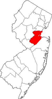
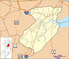 Orchard Heights, New Jersey Location of Orchard Heights in Middlesex County Inset: Location of county within the state of New Jersey  Orchard Heights, New Jersey Orchard Heights, New Jersey (New Jersey)  Orchard Heights, New Jersey Orchard Heights, New Jersey (the US) | |
| Coordinates: 40°26′13″N 74°24′11″W / 40.43694°N 74.40306°WCoordinates: 40°26′13″N 74°24′11″W / 40.43694°N 74.40306°W | |
| Country |
|
| State |
|
| County | Middlesex |
| Township | East Brunswick |
| Elevation[1] | 112 ft (34 m) |
| GNIS feature ID | 879007[1] |
Orchard Heights is an unincorporated community located within East Brunswick Township in Middlesex County, New Jersey, United States. The area is part of a suburban residential neighborhood near the Cranbury Road (County Route 535) interchange with New Jersey Route 18. Near the area includes two schools (one elementary school and East Brunswick High School), churches, and St. Mary's Cemetery.[2]
References
- 1 2 "Orchard Heights". Geographic Names Information System. United States Geological Survey.
- ↑ Google (February 13, 2015). "Orchard Heights, New Jersey" (Map). Google Maps. Google. Retrieved February 13, 2015.
This article is issued from
Wikipedia.
The text is licensed under Creative Commons - Attribution - Sharealike.
Additional terms may apply for the media files.