Top Road, Trenton, New Jersey
| Top Road, New Jersey | |
|---|---|
| Unincorporated community | |
_at_the_intersection_with_Olden_Avenue_(Mercer_County_Route_622)_in_the_Top_Road_section_of_Trenton%2C_New_Jersey.jpg) View north along Brunswick Avenue (U.S. Route 206) at Olden Avenue in Top Road | |
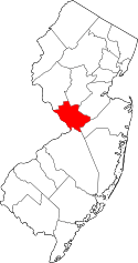
 Top Road, New Jersey Location of Top Road in Mercer County Inset: Location of county within the state of New Jersey  Top Road, New Jersey Top Road, New Jersey (New Jersey)  Top Road, New Jersey Top Road, New Jersey (the US) | |
| Coordinates: 40°14′26″N 74°44′38″W / 40.24056°N 74.74389°WCoordinates: 40°14′26″N 74°44′38″W / 40.24056°N 74.74389°W | |
| Country |
|
| State |
|
| County | Mercer |
| City | Trenton |
Top Road is a neighborhood located within the city of Trenton in Mercer County, New Jersey, United States.[1][2][3] Much of Top Road was once part of Lawrence Township and then was added to the now-defunct Millham Township before being annexed by Trenton in 1888.[4]
Demographics
Census 2010
The United States Census Bureau estimates that the population of Top Road was 3,008 as of the 2010 United States Census. The population density was 9,490/sq mi.[5]
Top Road is an ethnically diverse neighborhood of Trenton. As of the 2010 United States Census, 44.5% of the population was foreign-born. Poland was the top country of origin, representing 35.7% of all foreign-born residents in Top Road. The Dominican Republic was the second-most common country of origin with 18% of the total; Costa Rica, Mexico, and Guatemala followed with 9.3%, 6.6%, and 5.8% respectively. India was the top country of origin outside of Europe and the Americas, representing 5% of the foreign-born population.[6]
Spanish and Polish were the top two languages spoken at home. Spanish was spoken at home by 30.4% of residents, while 15.3% spoke Polish at home.[7]
References
- ↑ Locality Search, State of New Jersey. Accessed January 10, 2015.
- ↑ Google (January 10, 2015). "Top Road, Trenton, New Jersey" (Map). Google Maps. Google. Retrieved January 10, 2015.
- ↑ "City Profile Report: Trenton 250: 1792-2042: A City Master Plan Document" (PDF). City of Trenton. Archived from the original (PDF) on 2015-01-21. Retrieved 2015-01-20.
- ↑ "North Ward Historic Resource Survey, City of Trenton". Trenton Historical Society. Retrieved 2015-01-18.
When the City of Trenton first incorporated in 1792, its boundaries included the neighborhood known as East Trenton. However, in 1844, Lawrence Township annexed this area. It remained part of Lawrence Township until 1882, when East Trenton became an independent jurisdiction known as Millham Township, which included much of Top Road. On May 1, 1888, Millham once again became part of the City. of Trenton.
- ↑ "Population of Top Road, Trenton, New Jersey". StatisticalAtlas.com. Retrieved July 12, 2018.
- ↑ "National Origin in Top Road, Trenton, New Jersey". StatisticalAtlas.com. Retrieved July 12, 2018.
- ↑ "Languages in Top Road, Trenton, New Jersey". StatisticalAtlas.com. Retrieved July 12, 2018.