Harbourton, New Jersey
| Harbourton, New Jersey | |
|---|---|
| Unincorporated community | |
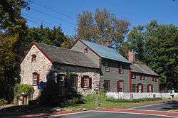 Old village store in Harbourton. | |
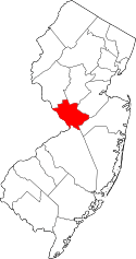
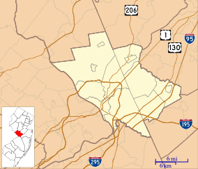 Harbourton, New Jersey Location of Harbourton in Mercer County Inset: Location of county within the state of New Jersey  Harbourton, New Jersey Harbourton, New Jersey (New Jersey)  Harbourton, New Jersey Harbourton, New Jersey (the US) | |
| Coordinates: 40°21′08″N 74°51′08″W / 40.35222°N 74.85222°WCoordinates: 40°21′08″N 74°51′08″W / 40.35222°N 74.85222°W | |
| Country |
|
| State |
|
| County | Mercer |
| Township | Hopewell |
| Elevation[1] | 331 ft (101 m) |
| GNIS feature ID | 876941[1] |
|
Harbourton Historic District | |
| Location | Hopewell Township, Mercer County, New Jersey, United States |
|---|---|
| NRHP reference # | 74001167[2] |
| Added to NRHP | December 31, 1974 |
Harbourton is a historic unincorporated community located within Hopewell Township in Mercer County, New Jersey, United States.[3] It is located along County Route 579 at the intersection with Harbourton-Mount Airy Road. The community was added to the National Register of Historic Places in 1974.
References
- 1 2 "Harbourton". Geographic Names Information System. United States Geological Survey.
- ↑ National Park Service (2009-03-13). "National Register Information System". National Register of Historic Places. National Park Service.
- ↑ Locality Search, State of New Jersey. Accessed January 8, 2015.
This article is issued from
Wikipedia.
The text is licensed under Creative Commons - Attribution - Sharealike.
Additional terms may apply for the media files.