Chewalla Park, New Jersey
| Chewalla Park, New Jersey | |
|---|---|
| Unincorporated community | |
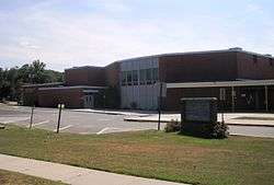 Nottingham High School in Chewalla Park | |
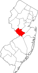
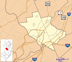 Chewalla Park, New Jersey Location of Chewalla Park in Mercer County Inset: Location of county within the state of New Jersey  Chewalla Park, New Jersey Chewalla Park, New Jersey (New Jersey)  Chewalla Park, New Jersey Chewalla Park, New Jersey (the US) | |
| Coordinates: 40°13′53″N 74°42′45″W / 40.23139°N 74.71250°WCoordinates: 40°13′53″N 74°42′45″W / 40.23139°N 74.71250°W | |
| Country |
|
| State |
|
| County | Mercer |
| Township | Hamilton |
| Elevation[1] | 56 ft (17 m) |
| GNIS feature ID | 875413[1] |
Chewalla Park is an unincorporated community located within Hamilton Township in Mercer County, New Jersey, United States.[2] The neighborhood is roughly bounded by Hamilton Avenue (County Route 606), Klockner Road, Nottingham Way (New Jersey Route 33), and the Greenwood Cemetery. Nottingham High School is located in Chewalla Park at the intersection of Hamilton Avenue and Klockner Road.[2]
References
- 1 2 "Chewalla Park". Geographic Names Information System. United States Geological Survey.
- 1 2 Google (January 9, 2015). "Chewalla Park, New Jersey" (Map). Google Maps. Google. Retrieved January 9, 2015.
This article is issued from
Wikipedia.
The text is licensed under Creative Commons - Attribution - Sharealike.
Additional terms may apply for the media files.