Tijarafe
| Tijarafe | |
|---|---|
| Municipality | |
 | |
 Tijarafe Location in Canary Islands | |
| Coordinates: 28°42′40″N 17°57′20″W / 28.71111°N 17.95556°WCoordinates: 28°42′40″N 17°57′20″W / 28.71111°N 17.95556°W | |
| Country | Spain |
| Autonomous community | Canary Islands |
| Province | Santa Cruz de Tenerife |
| Island | La Palma |
| Area[1] | |
| • Total | 53.76 km2 (20.76 sq mi) |
| Population (2013)[2] | |
| • Total | 2,776 |
| • Density | 52/km2 (130/sq mi) |
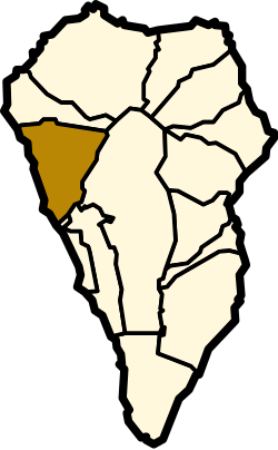
Tijarafe is a town and a municipality on the island of La Palma, Province of Santa Cruz de Tenerife, Canary Islands, Spain. It is situated in the northwestern part of the island. The population of the municipality is 2,776 (2013)[2] and the area is 53.76 km².[1] Tijarafe is 7 km northwest of Los Llanos de Aridane and 19 km west of the island capital Santa Cruz de La Palma.
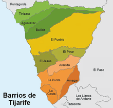
The eastern border of the municipality is formed by the crater rim of the Caldera de Taburiente and its outflow, the Barranco de las Angustias.
Tijarafe was the name of one of the twelve old areas where the Guanches used to settle before the Spanish conquest. It corresponded with the present municipalities Tijarafe and Puntagorda.
Historical population
| Year | Population |
|---|---|
| 1991 | 2,195 |
| 1996 | 2,658 |
| 2001 | 2,730 |
| 2002 | 2,765 |
| 2003 | 2,687 |
| 2004 | 2,666 |
| 2008 | 2,757 |
| 2009 | 2,768 |
| 2013 | 2,776 |
See also
References
- 1 2 Instituto Canario de Estadística, area
- 1 2 Instituto Canario de Estadística, population
Places adjacent to Tijarafe | |
|---|---|
This article is issued from
Wikipedia.
The text is licensed under Creative Commons - Attribution - Sharealike.
Additional terms may apply for the media files.