Hermigua
| Hermigua | |||
|---|---|---|---|
| Municipality | |||
 Hermigua's coast | |||
| |||
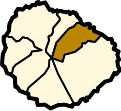 Location of Hermigua on La Gomera | |||
 Hermigua Location in the Canary Islands  Hermigua Hermigua (Spain, Canary Islands) | |||
| Coordinates: 28°10′02″N 17°11′32″W / 28.16722°N 17.19222°WCoordinates: 28°10′02″N 17°11′32″W / 28.16722°N 17.19222°W | |||
| Country |
| ||
| Autonomous community |
| ||
| Province |
| ||
| Island |
| ||
| Area[1] | |||
| • Total | 39.67 km2 (15.32 sq mi) | ||
| Elevation[1] | 210 m (690 ft) | ||
| Population (2009)[2] | |||
| • Total | 2,203 | ||
| • Density | 56/km2 (140/sq mi) | ||

Hermigua is a town and a municipality in the northeastern part of La Gomera in the province of Santa Cruz de Tenerife of the Canary Islands, Spain. It is located 12 km northwest of the island's capital, San Sebastián de la Gomera. The Garajonay National Park covers the southern part of the municipality.
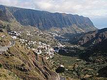
Landscape of Hermigua
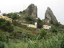
Roques de San Pedro
There are cedar forests in the area known as El Cedro. The valley was first inhabited by the Guanches and was known as Mulagua. The municipality of Hermigua was founded in the 16th century as the settlement of Valle Bajo.
Settlements
- Valle Bajo divides the settlements of El Curato and El Palmerejo
- Valle Alto divides the settlements of La Castellana and Playa Hermigua
- El Cabo
- Monteforte
- Los Estanquillos
- El Corralete
- El Convento
- La Cerca
- Las Hoyetas
- Caserío del Cedro
Historical population
| Year | Population |
|---|---|
| 1991 | 2,120 |
| 1996 | 2,150 |
| 2001 | 2,038 |
| 2002 | 2,151 |
| 2003 | 2,167 |
| 2004 | 2,176 |
| 2013 | 2,103 |
Sites of interest
- Valle Alto, the first settlement in Hermigua: its neighbourhood "El Convento" features a Dominican church and monastery built 1611; another landmark is the Escuela popular
- El Chorro waterfall
- Los Telares Museum: contains handicrafts from the surrounding area
- "Roques Pedro y Petra"
- "El Curato"
- "El Pescante" (The Old Davit)
- "El Caserío del Cedro": a hamlet by the National Park in a small isolated valley
- "Playa de La Caleta" (La Caleta Beach)
- "Ermita de San Juan"
- Mahona Natural Reserve
See also
References
- 1 2 "SUPERFICIE, PERÍMETRO Y ALTITUD DE LOS MUNICIPIOS DE CANARIAS" (in Spanish). Instituto Canario de Estadística (ISTAC).
- ↑ "Población en Canarias. La Gomera. 1-1-2009" (in Spanish). Instituto Canario de Estadística (ISTAC). Archived from the original on 2010-11-13.
External links
| Wikimedia Commons has media related to Hermigua. |
Places adjacent to Hermigua | |
|---|---|
This article is issued from
Wikipedia.
The text is licensed under Creative Commons - Attribution - Sharealike.
Additional terms may apply for the media files.