Valle Gran Rey
| Valle Gran Rey | |
|---|---|
| Municipality | |
 Valle Gran Rey | |
 Municipal location in La Gomera | |
 Valle Gran Rey Location in Canary Islands | |
| Coordinates: 28°6′N 17°20′W / 28.100°N 17.333°WCoordinates: 28°6′N 17°20′W / 28.100°N 17.333°W | |
| Country |
|
| Autonomous Region | Canary Islands |
| Province | Santa Cruz de Tenerife |
| Island | La Gomera |
| Government | |
| • Mayor | Angel Piñero Cruz |
| Area[1] | |
| • Total | 32.36 km2 (12.49 sq mi) |
| Population (2013)[2] | |
| • Total | 4,240 |
| • Density | 130/km2 (340/sq mi) |
| Time zone | UTC+0 (GMT) |

Vueltas harbour
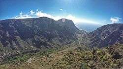
Valle Gran Rey is a municipality in the western part of the island La Gomera, in the province of Santa Cruz de Tenerife of the Canary Islands, Spain. The Guanche name of the area was Orone.[3] The seat of the municipality since 1930 is La Calera; previously it was in Arure.
The population was 4,240 in 2013,[2] and the area is 32.36 square kilometres (12.49 sq mi).[1] Valle Gran Rey borders the municipality of Vallehermoso to the east, while the Atlantic Ocean lies to the west.
Subdivisions
- Arure
- La Calera (seat)
- Casa de la Seda
- El Guro
- Las Hayas
- El Hornillo
- Taguluche
- La Playa
- Vueltas
Historical population
| Year | Population |
|---|---|
| 1991 | 3,103 |
| 1996 | 3,631 |
| 2001 | 4,238 |
| 2002 | 4,248 |
| 2003 | 4,487 |
| 2004 | 4,745 |
| 2005 | 4,857 |
| 2013 | 4,240 |
Notable natives and residents
- Tim Hart (died 2009), English folk musician
- Oliver Weber, German photographer, physician and professor of visual arts
See also
References
- 1 2 Instituto Canario de Estadística, area
- 1 2 Instituto Canario de Estadística, population
- ↑ Asociación Canaria para la Enseñanza de las Ciencias "Viera y Clavijo" (October 2009). "cursos: "Ecosistemas gomeros"". Retrieved 2010-02-10.
External links
| Wikimedia Commons has media related to Valle Gran Rey. |
- (in Spanish) Website Valle Gran Rey
- Blog La Gomera
Places adjacent to Valle Gran Rey | ||||||||||
|---|---|---|---|---|---|---|---|---|---|---|
| ||||||||||
This article is issued from
Wikipedia.
The text is licensed under Creative Commons - Attribution - Sharealike.
Additional terms may apply for the media files.