Tazacorte
| Tazacorte | |||
|---|---|---|---|
| Municipality | |||
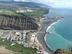 The port of Tazacorte | |||
| |||
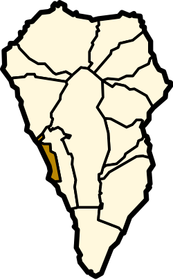 Location in La Palma | |||
 Tazacorte Location in the Canary Islands  Tazacorte Tazacorte (Spain, Canary Islands) | |||
| Coordinates: 28°38′30″N 17°56′0″W / 28.64167°N 17.93333°WCoordinates: 28°38′30″N 17°56′0″W / 28.64167°N 17.93333°W | |||
| Country | Spain | ||
| Autonomous community | Canary Islands | ||
| Province | Santa Cruz de Tenerife | ||
| Island | La Palma | ||
| Area[1] | |||
| • Total | 11.37 km2 (4.39 sq mi) | ||
| Elevation | 132 m (433 ft) | ||
| Population (2013)[2] | |||
| • Total | 4,911 | ||
| • Density | 430/km2 (1,100/sq mi) | ||

Tazacorte is a town and a municipality on the island of La Palma, Province of Santa Cruz de Tenerife, Canary Islands, Spain. It is situated near the coast, in the western part of the island. The population of the municipality is 4,911 (2013)[2] and the area is 11.37 km².[1] The average elevation is 60 m. Tazacorte is 2 km southwest of Los Llanos de Aridane and 17 km west of the island capital Santa Cruz de La Palma. The inhabitants are known as Bagañetes.
Farmlands, producing almost exclusively bananas, occupy as much as 85% of the land area of Tazacorte. The widespread use, and occasional continued misuse, of insecticides has led to significant concern, as cancer rates for residents is higher than national statistics.[3]
Historical population
| Year | Population |
|---|---|
| 1991 | 6,502 |
| 1996 | 6,909 |
| 2001 | 5,062 |
| 2002 | 6,108 |
| 2003 | 6,107 |
| 2004 | 5,797 |
| 2013 | 4,911 |
See also
References
| Wikimedia Commons has media related to Tazacorte. |
- 1 2 Instituto Canario de Estadística, area
- 1 2 Instituto Canario de Estadística Archived 2014-04-18 at the Wayback Machine., population
- ↑ G. López-Abente; M. Pollán; N. Aragonés; B. Pérez Gómez; V. Hernández Barrera; V. Lope; B. Suárez. "Situación del cáncer en España: incidencia" (in Spanish). Centro Nacional de Epidemiología.
Places adjacent to Tazacorte | ||||||||||
|---|---|---|---|---|---|---|---|---|---|---|
| ||||||||||
This article is issued from
Wikipedia.
The text is licensed under Creative Commons - Attribution - Sharealike.
Additional terms may apply for the media files.