Santa Úrsula
| Santa Úrsula | |||
|---|---|---|---|
| Municipality | |||
.jpg) Town Hall | |||
| |||
 Santa Úrsula in Tenerife | |||
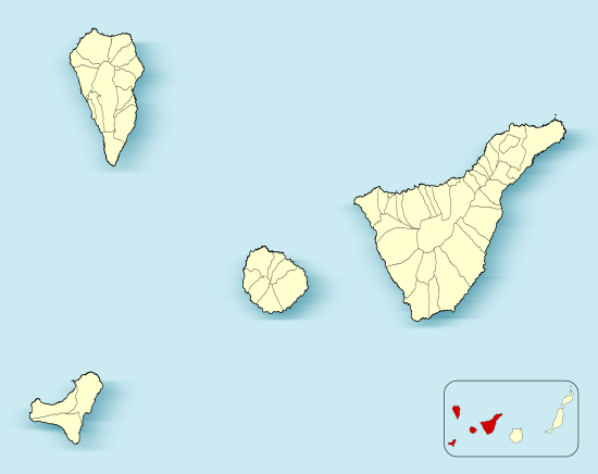 Santa Úrsula Location in Province of Santa Cruz de Tenerife  Santa Úrsula Santa Úrsula (Canary Islands)  Santa Úrsula Santa Úrsula (Spain, Canary Islands) | |||
| Coordinates: 28°25′30″N 16°29′30″W / 28.42500°N 16.49167°W | |||
| Country |
| ||
| Autonomous Community |
| ||
| Province | Tenerife | ||
| Island | Tenerife | ||
| Government | |||
| • Mayor | Milagros Pérez de León (PP) | ||
| Area[1] | |||
| • Total | 22.59 km2 (8.72 sq mi) | ||
| Elevation(AMSL) | 290 m (950 ft) | ||
| Population (2013)[2] | |||
| • Total | 14,545 | ||
| • Density | 640/km2 (1,700/sq mi) | ||
| Time zone | UTC+0 (CET) | ||
| • Summer (DST) | UTC+1 (CEST (GMT +1)) | ||
| Postal code | 38390 | ||
| Area code(s) | +34 (Spain) + 922 (Tenerife) | ||
| Climate | BSh | ||
| Website | www.santaursula.es | ||
Úrsula (named after Saint Ursula) is a town and a municipality on the north coast of Tenerife. It is located 6 km east of Puerto de la Cruz and 24 km west of the island's capital, Santa Cruz de Tenerife. The population is 14,545 (2013[2]) and the area is 22.59 km².[1] The elevation is 290 m. The TF-5 motorway passes through the municipality.
Historical population
| Year | Population |
|---|---|
| 1991 | 8,599 |
| 1996 | 9,591 |
| 2001 | 10,803 |
| 2002 | 11,571 |
| 2003 | 11,959 |
| 2004 | 12,237 |
| 2013 | 14,545 |
See also
References
- 1 2 Instituto Canario de Estadística, area
- 1 2 Instituto Canario de Estadística Archived 2014-04-19 at the Wayback Machine., population
Places adjacent to Santa Úrsula | ||||||||||
|---|---|---|---|---|---|---|---|---|---|---|
| ||||||||||
This article is issued from
Wikipedia.
The text is licensed under Creative Commons - Attribution - Sharealike.
Additional terms may apply for the media files.