Caldera de Taburiente National Park
| Caldera de Taburiente National Park | |
|---|---|
| Parque Nacional de la Caldera de Taburiente | |
|
IUCN category II (national park) | |
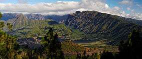 Inside of the caldera | |
| Location | La Palma, Canary Islands, Spain |
| Coordinates | 28°43′N 17°52′W / 28.717°N 17.867°WCoordinates: 28°43′N 17°52′W / 28.717°N 17.867°W |
| Established | 1954 |

Caldera de Taburiente National Park (Spanish: Parque Nacional de la Caldera de Taburiente) is a large geological feature on the island of La Palma, Canary Islands, Spain. It contains the enormous expanse of the Caldera de Taburiente which dominates the northern part of the island, and was designated as a national park in 1954. The telescopes of the Roque de los Muchachos Observatory are situated very close to the summit.
Topography and flora
The caldera is about 10 km across, and in places the walls tower 2000 m over the caldera floor. The highest point is the Roque de los Muchachos on the northern wall, at 2426 m altitude, which can be reached by road. The Cumbrecita is at a lower point in the south-eastern part of the caldera's rim, giving a good view into the Caldera. In the south-west the caldera opens to the sea, through a riverbed known as Barranco de las Angustias. The Cumbre Nueva is a ridge that starts at the caldera and continues to the south.
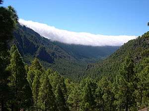
The main flora of the national park comprises a large forest of Canary Island Pine, with important population of the endangered Canary Islands Juniper also present.
Geological origins

The caldera originated some 2 million years ago, with a massive shield volcano about 20 km in diameter. The caldera was not formed by an explosion of that volcano however, but by erosion starting from the volcano's original crater.
Modern history
During the Spanish conquest of the Canary Islands in the 15th century, the caldera was the site of the last stand of the indigenous people of the archipelago, a branch of the Guanches known as Benahoaritas. It proved impregnable to the invading Spaniards, and they only defeated the Benahoarita by luring their leader out on the pretext of holding talks.
Once believed to be a huge crater, science in the early 1800s it was to be a mountain arch with a curious crater shape. In 1815 the great German geologist Christian Leopold von Buch visited the Canary Islands, during which he visited the island of Tenerife where he was taken to the Caldera de las Cañadas. He visited La Palma after he had been to Tenerife, and in his journal he makes it clear that he was able to distinguish between a caldera of volcanic origin and the erosional origins for the caldera Taburiente. Following his return to Germany he published his journal and he introduced the term "Caldera" to the geological vocabulary.
In the 1830s the caldera provided inspiration for some remarkable art that combined a study of geology with botany. Such as the work of Sabin Berthelot and Felix-Achille St. Aulaire[1]
Name
The word "caldera" means "cauldron" in Spanish. Taburiente is not a Spanish word but derives from the Guanche language and means "plain, level".[2]
See also
References
| Wikimedia Commons has media related to Caldera de Taburiente. |
- ↑ Met Museum New York, "A Memory of Caldera" by Felix-Achille St. Aulaire, online at http://www.metmuseum.org/art/collection/search/356782
- ↑ Carmen Díaz Alayón (1987): Materiales toponímicos de La Palma, Excmo. Cabildo Insular de La Palma, págs. 142-145