Temple Hills, Maryland
| Temple Hills, Maryland | |
|---|---|
| Census-designated place | |
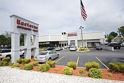 Easterns Automotive Group store in Temple Hills | |
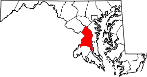
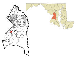 Location of Temple Hills, Maryland | |
| Coordinates: 38°48′38″N 76°56′47″W / 38.81056°N 76.94639°WCoordinates: 38°48′38″N 76°56′47″W / 38.81056°N 76.94639°W | |
| Country |
|
| State |
|
| County |
|
| Area | |
| • Total | 1.4 sq mi (3.5 km2) |
| • Land | 1.4 sq mi (3.5 km2) |
| • Water | 0.0 sq mi (0.0 km2) |
| Elevation | 269 ft (82 m) |
| Population (2010) | |
| • Total | 7,852 |
| • Density | 5,600/sq mi (2,200/km2) |
| Time zone | UTC−5 (Eastern (EST)) |
| • Summer (DST) | UTC−4 (EDT) |
| Area code(s) | 301 |
| FIPS code | 24-77100 |
| GNIS feature ID | 0598158 |
Temple Hills is a suburb of Washington, D.C., southeast of the downtown district. It is an unincorporated area and census-designated place (CDP) in Prince George's County, Maryland, United States.[1] As of the 2010 census it had a population of 7,852.[2]
The community was named after Dr. Edward Temple, who in the 1860s lived in a home beside Henson Creek known as Moor Park.[3] Within the area are numerous garden apartments, duplexes, and single family communities constructed mostly from the 1950s through 1970s. The large community of Hillcrest Heights is nearby (and has a Temple Hills mailing address), with the 1960s 2-level Iverson Mall and Marlow Heights shopping centers.
Rosecroft Raceway (since 1949, harness horse racing) is nearby in Oxon Hill, although the racing audience has declined greatly. There are large public indoor and outdoor swimming pools operated by the Maryland-National Capital Park and Planning Commission, and also the private Temple Hills Swim Club. The area is especially convenient to the Capital Beltway (I-95/I-495), the Metrorail Green Line, Andrews Air Force Base, the U.S. Census Bureau, and Capitol Hill.
Since the clogged interstate Woodrow Wilson Bridge was widened in 2008, commuter access to Northern Virginia's booming job market has improved.
Geography
Temple Hills is located at 38°48′38″N 76°56′47″W / 38.81056°N 76.94639°W (38.810580, −76.946360).[4]
According to the United States Census Bureau, the CDP has a total area of 1.4 square miles (3.6 km2), all of it land.
Demographics
| Historical population | |||
|---|---|---|---|
| Census | Pop. | %± | |
| 1980 | 6,630 | — | |
| 1990 | 6,865 | 3.5% | |
| 2000 | 7,792 | 13.5% | |
| 2010 | 7,852 | 0.8% | |
| source:[2][5] | |||
At the 2000 census,[6] there were 7,792 people, 3,156 households and 1,937 families residing in the CDP. The population density was 5,756.1 per square mile (2,228.5/km²). There were 3,388 housing units at an average density of 2,502.8/sq mi (969.0/km²). The racial makeup of the CDP was 9.32% White, 85.01% African American, 0.21% Native American, 1.40% Asian, 0.15% Pacific Islander, 2.37% from other races, and 1.54% from two or more races. Hispanic or Latino of any race were 4.39% of the population.
There were 3,156 households of which 36.7% had children under the age of 18 living with them, 28.8% were married couples living together, 27.1% had a female householder with no husband present, and 38.6% were non-families. 32.3% of all households were made up of individuals and 3.2% had someone living alone who was 65 years of age or older. The average household size was 2.47 and the average family size was 3.11.
Age distribution was 29.6% under the age of 18, 10.2% from 18 to 24, 37.0% from 25 to 44, 18.3% from 45 to 64, and 4.9% who were 65 years of age or older. The median age was 30 years. For every 100 females, there were 82.9 males. For every 100 females age 18 and over, there were 74.2 males.
The median household income was $44,868 and the median family income was $49,318. Males had a median income of $35,192 compared with $32,500 for females. The per capita income for the CDP was $21,939. About 9.9% of families and 10.4% of the population were below the poverty line, including 16.4% of those under age 18 and 2.9% of those age 65 or over.
Government
Prince George's County Police Department District 4 Station in Glassmanor CDP, with an Oxon Hill postal address, serves the community.[7]
The United States Postal Service operates the Temple Hills Post Office in the Marlow Heights CDP, with a Temple Hills postal address.[8] It also operates the Anacostia Carrier Annex in the Hillcrest Heights CDP, also with a Temple Hills postal address.[9]
Education
The CDP is served by the Prince George's County Public Schools district.[10]
Samuel Chase and J. Frank Dent elementaries serve sections of the CDP.[11] All residents of the CDP are zoned to Thurgood Marshall Middle School,[12] and Crossland High School.[13] Crossland High is physically in Camp Springs CDP and has a Temple Hills postal address.[14]
Notable people
- Mark Davis, radio talk show host and columnist, now in Dallas-Ft. Worth, grew up in Temple Hills
- Mike Easton, bantamweight for the Ultimate Fighting Championship
- Peter Bergman, actor on The Young and the Restless
- William T. Randall, (1915–2013) a Negro League baseball player
- Frank Small, Jr., member of U.S. House of Representatives Maryland's 5th District, 1953-1955, born in Temple Hills in 1896
- Julian Peterson, linebacker for the Detroit Lions
- Michael A. Jackson, former sheriff
References
- ↑ U.S. Geological Survey Geographic Names Information System: Temple Hills, Maryland
- 1 2 "Profile of General Population and Housing Characteristics: 2010 Demographic Profile Data (DP-1): Temple Hills CDP, Maryland". U.S. Census Bureau, American Factfinder. Retrieved December 23, 2011.
- ↑ "Henson Creek Trail" brochure, Maryland-National Capital Parks and Planning Commission
- ↑ "US Gazetteer files: 2010, 2000, and 1990". United States Census Bureau. 2011-02-12. Retrieved 2011-04-23.
- ↑ "CENSUS OF POPULATION AND HOUSING (1790-2000)". U.S. Census Bureau. Retrieved 2010-07-17.
- ↑ "American FactFinder". United States Census Bureau. Retrieved 2008-01-31.
- ↑ "District 4 Station - Oxon Hill." Prince George's County Police Department. Retrieved on September 9, 2018. " 5135 Indian Head Highway Oxon Hill, MD 20745". Beat map. See 2010 U.S. Census Map of Glassmanor CDP.
- ↑ "TEMPLE HILLS." United States Postal Service. Retrieved on September 11, 2018. "4806 SAINT BARNABAS RD TEMPLE HILLS, MD 20748-9997" - See: "2010 CENSUS - CENSUS BLOCK MAP: Marlow Heights CDP, MD." U.S. Census Bureau. Retrieved on August 29, 2018.
- ↑ "ANACOSTIA CARRIER ANNEX." United States Postal Service. Retrieved on September 11, 2018. "3719 BRANCH AVE TEMPLE HILLS, MD 20748-9993" - See: "2010 CENSUS - CENSUS BLOCK MAP: Hillcrest Heights CDP, MD." U.S. Census Bureau. Retrieved on August 29, 2018.
- ↑ "2010 CENSUS - CENSUS BLOCK MAP: Temple Hills CDP, MD." U.S. Census Bureau. Retrieved on August 29, 2018.
- ↑ "NEIGHBORHOOD ELEMENTARY SCHOOLS AND BOUNDARIES SCHOOL YEAR 2018-2019." Prince George's County Public Schools. Retrieved on August 29, 2018.
- ↑ "NEIGHBORHOOD MIDDLE SCHOOLS AND BOUNDARIES SCHOOL YEAR 2018-2019." Prince George's County Public Schools. Retrieved on August 29, 2018.
- ↑ "NEIGHBORHOOD HIGH SCHOOLS AND BOUNDARIES SCHOOL YEAR 2018-2019." Prince George's County Public Schools. Retrieved on August 29, 2018.
- ↑ Home. Crossland High School. Retrieved on August 29, 2018. "Crossland High School 6901 Temple Hills Road Temple Hills, MD 20748" - See: "2010 CENSUS - CENSUS BLOCK MAP (INDEX): Camp Springs CDP, MD." U.S. Census Bureau. Retrieved on August 29, 2018. p. 1 and 2.