Tassullo
| fraz.Tassullo - Ville d'Anaunia | |
|---|---|
| Comune | |
| Tassullo fraz. di Ville d'Anaunia | |
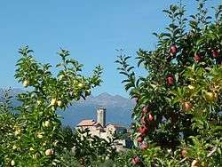 Castel Valer (Castello di Tassullo) | |
 fraz.Tassullo - Ville d'Anaunia Location of fraz.Tassullo - Ville d'Anaunia in Italy | |
| Coordinates: 46°20′N 11°3′E / 46.333°N 11.050°ECoordinates: 46°20′N 11°3′E / 46.333°N 11.050°E | |
| Country | Italy |
| Region | Trentino-Alto Adige/Südtirol |
| Province | Trentino (TN) |
| Area | |
| • Total | 13.5 km2 (5.2 sq mi) |
| Elevation | 546 m (1,791 ft) |
| Population (Giugno 2015) | |
| • Total | Ville d'Anaunia: 4,918 |
| Time zone | UTC+1 (CET) |
| • Summer (DST) | UTC+2 (CEST) |
| Postal code | 38010 |
| Dialing code | 0463 |
| Website | Official website |
Tassullo (Ladin: Tasul, German: Tassul) is a frazione of the municipality of Ville d'Anaunia (municipality) in Trentino in the northern Italian region Trentino-Alto Adige/Südtirol, located about 42 kilometres (26 mi) north of Trento. As of 31 December 2004, it had a population of 1,856 and an area of 13.5 square kilometres (5.2 sq mi).[1]
The municipality of Ville d'Anaunia contains the frazioni (subdivisions, mainly villages and hamlets) Rallo, Sanzenone, Pavillo, Tassullo, Campo, Tuenno, Nanno and Portolo.
Tassullo borders the following municipalities: Sanzeno and Cles.
Demographic evolution
| Historical population | |||||||||||||||||||||||||||||||||||||||||||||||||
|---|---|---|---|---|---|---|---|---|---|---|---|---|---|---|---|---|---|---|---|---|---|---|---|---|---|---|---|---|---|---|---|---|---|---|---|---|---|---|---|---|---|---|---|---|---|---|---|---|---|
|
| ||||||||||||||||||||||||||||||||||||||||||||||||
References
External links
- (in Italian) Homepage of the city

This article is issued from
Wikipedia.
The text is licensed under Creative Commons - Attribution - Sharealike.
Additional terms may apply for the media files.