Mezzocorona
| Mezzocorona | ||
|---|---|---|
| Comune | ||
| Comune di Mezzocorona | ||
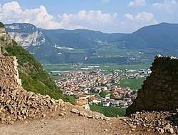 Mezzocorona from Castel San Gottardo | ||
| ||
 Mezzocorona Location of Mezzocorona in Italy | ||
| Coordinates: 46°13′N 11°7′E / 46.217°N 11.117°E | ||
| Country | Italy | |
| Region | Trentino-Alto Adige/Südtirol | |
| Province | Trentino (TN) | |
| Government | ||
| • Mayor | Mattia Hauser | |
| Area | ||
| • Total | 25 km2 (10 sq mi) | |
| Elevation | 219 m (719 ft) | |
| Population (31 October 2017) | ||
| • Total | 5,477 | |
| • Density | 220/km2 (570/sq mi) | |
| Demonym(s) | Mezzocoronesi, Brusacristi | |
| Time zone | UTC+1 (CET) | |
| • Summer (DST) | UTC+2 (CEST) | |
| Postal code | 38016 | |
| Dialing code | 0461 | |
| Patron saint | Saint Gothard | |
| Website | Official website | |
Mezzocorona (Italian pronunciation: [,mɛddzokoˈrona]; German: Kronmetz [ˈkʁoːnmɛts]), is a comune (municipality) in Trentino in the northern Italian region Trentino-Alto Adige/Südtirol, located about 15 kilometres (9 mi) north of the city of Trento.
Toponymy
The name is thought to derive from the Italian words mezzo, meaning "middle" or "in-between", and corona, which means "crown" (and is likely a reference to the shape of nearby Castel San Gottardo). Another possible origin is to be found in the dialect of the area: mez (with the variant miz) which means "wet, soggy". In fact, Mezzocorona was a marshy area until the XIX century, when swamplands were eventually reclaimed and Noce's outlet into Adige River moved further downstream, near Zambana.
In 1194 the Counts of Tyrol took control of the area. After this event, the toponym Mezzotedesco (German: Deutschmetz) (= "German middle") came into use, in opposition to her twin town Mezzolombardo (= "Lombard middle") which, instead, remained in the hands of the Bishopric of Trent and therefore under Italian influence.[1]
On 29 February 1902 the Viennese Ministry of the Interior allowed the name change from Mezzotedesco to Mezocorona, in the corresponding German form of "Kronmetz".[2] The current name dates back to 1924.[3]
The inhabitants are called Mezzocoronesi or rarely Brusacristi. Behind the latter demonym there is a bizarre story: its inhabitants were nicknamed Brusacristi (literally "Christburners") for burning a cross placed by the inhabitants of Mezzolombardo to mark the banks of the Noce River.[4]
Geography
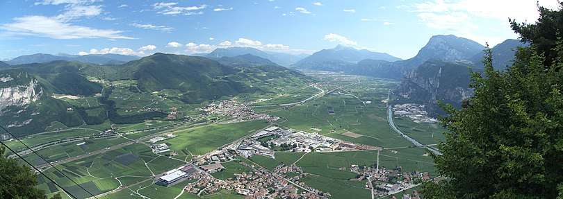
Mezzocorona is located in the Rotaliana Plain, an alluvial plain situated at the confluence of the Non Valley with the Etschtal. The village lies at the foot of a steep rocky mountain wall (Monte di Mezzocorona) that shields it from the cold northern winds. This particular conformation has resulted in a milder climate than that of the surrounding areas, allowing the vine to grow plentifully in this region. Its territory is crossed by two water streams, the Adige River and the Noce River.
The Teroldego grape variety is native to this area.
Mezzocorona borders the following municipalities: Mezzolombardo, Ton, Roverè della Luna, San Michele all'Adige and Nave San Rocco.
History
The Rotaliana plain has been continually inhabited since prehistorical times with documented evidence, such as the remains of an ancient woman dating back to the Mesolithic period. This finding sparked interest among the citizens, who refer to this skeleton as Nonna di Mezzocorona (= "Grandma of Mezzocorona").[5]
Thanks to the Adige River and the Claudia Augusta Imperial Road, the area of Mezzocorona has served as a strategic road junction between the valleys of the Adige, Noce and Avisio Rivers ever since the times of the Romans. But the first written evidence goes back to 1199[3] and refers to the church, the venue of the ancient Parish of Santa Maria, which also comprised some nearby villages.
Similarly to other realities in Trentino, Mezzocorona was also ruled by an agrarian community called Vicinia of Mezzocorona (Comunitas Meçi de Corona), which was first mentioned during the investiture of the Bishop of Trento, Egnone, dating back to 1271.[3] The Mezzocorona Vicinia extended as far as Roverè della Luna and Grumo and consisted of many fuochi (entitled families) or masi (farmsteads): 50 in Mezzocorona, 18 in Roverè della Luna and 10 in Grumo. Everyday life was regulated by a set of rules called Carta di Regola or Vicinia Statute by which everyone had to abide. The seat of the community was the Palazzo della Vicinia, today the public library.
In the first half of the 14th century, following the expansion policy of the Counts of Tyrol, the jurisdiction passed to their domain and the Tyrol Statute was implemented alongside with the Vicinia Statute. This represented the basic laws in force until the early 19th century.[3]
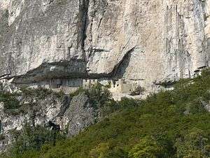
Historical noble families of Mezzocorona were the Mez family and after them, the Firmian family.[6] The Mez dinasty built their first manor in a crack of the mountain above the village, making it hard to be conquered. This castle, now known as Castel San Gottardo, was later abandoned for a more comfortable dwelling at the foot of the mountain under the Firmian family.
Society
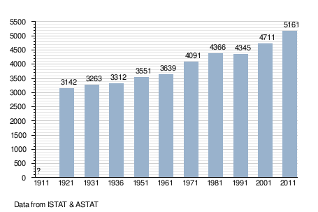
As of 31 December 2017, Mezzocorona had a population of 5477.[7]
Demographic evolution
Transport
Motorway
Rail
Mezzocorona has three railway stations:
- One railway station connected to the Brenner Railway
- Two railway stations (Mezzocorona Ferrovia and Mezzocorona Borgata) connected to the Trento–Malè–Mezzana railway
Cable car
The village is also served by a cablecar[8] that connects the village to the top of the Monte di Mezzocorona. From here, Malga Kraun can be reached in an hour's walk on the marked forest path n°500.
Gallery
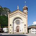 St Mary Church
 Palazzo della Vicinia, now the public library
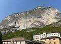 Castel Firmian (bottom) and Castel Gottardo (top)
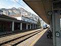 Mezzocorona Railway station
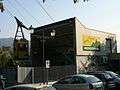 Cableway lower station
_Italy_-_August_6%2C_2006_-_panoramio.jpg) Via Ferrata Burrone Giovanelli
Via Ferrata Burrone Giovanelli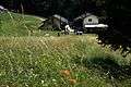 Malga Kraun
References
- ↑ Marcato, Carla (1990). Dizionario di toponomastica. Storia e significato dei nomi geografici italiani (in Italian). Turin: UTET. p. 393.
- ↑ Mezocorona (Kronmetz) Zoomable map: "TRIENT (1908) - K.u.K. Militärgeographisches Institut - 1:75 000 - 810 - Zone 21, Kol. IV"
- 1 2 3 4 "La Storia di Mezzocorona" (in Italian). Retrieved 3 September 2018.
- ↑ "Brusacristi contro Forcoloti?". QuestoTrentino (in Italian). Retrieved 3 September 2018.
- ↑ "Periodo mesolitico a Mezzocorona". Comune di Mezzocorona (in Italian). Retrieved 3 September 2018.
- ↑ "Castello di San Gottardo". Comune di Mezzocorona (in Italian). Retrieved 3 September 2018.
- ↑ "Bilancio demografico anno 2017 e popolazione residente al 31 dicembre Comune: Mezzocorona". demoISTAT.it. Retrieved 3 September 2018.
- ↑ "Funivia Monte di Mezzocorona". Funivia Monte di Mezzocorona.
External links
- Official website (in Italian)