Valfloriana
| Valfloriana | |
|---|---|
| Comune | |
| Comune di Valfloriana | |
 Valfloriana Location of Valfloriana in Italy | |
| Coordinates: 46°15′N 11°21′E / 46.250°N 11.350°ECoordinates: 46°15′N 11°21′E / 46.250°N 11.350°E | |
| Country | Italy |
| Region | Trentino-Alto Adige/Südtirol |
| Province | Trentino (TN) |
| Area | |
| • Total | 39.4 km2 (15.2 sq mi) |
| Population (Dec. 2004) | |
| • Total | 538 |
| • Density | 14/km2 (35/sq mi) |
| Time zone | UTC+1 (CET) |
| • Summer (DST) | UTC+2 (CEST) |
| Postal code | 38040 |
| Dialing code | 0462 |
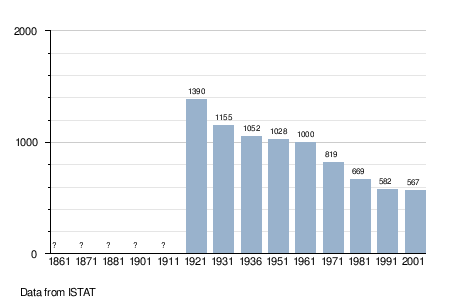
Valfloriana (German: Welsch-Flörian) is a comune (municipality) in Trentino in the northern Italian region Trentino-Alto Adige/Südtirol, located about 25 kilometres (16 mi) northeast of Trento. As of 31 December 2004, it had a population of 538 and an area of 39.4 square kilometres (15.2 sq mi).[1]
Valfloriana borders the following municipalities: Capriana, Altrei, Castello-Molina di Fiemme, Sover, Lona-Lases, Telve and Baselga di Pinè.
Demographic evolution
References

This article is issued from
Wikipedia.
The text is licensed under Creative Commons - Attribution - Sharealike.
Additional terms may apply for the media files.