Folgaria
| Folgaria | ||
|---|---|---|
| Comune | ||
| Comune di Folgaria | ||
| ||
 Folgaria Location of Folgaria in Italy | ||
| Coordinates: 45°55′N 11°11′E / 45.917°N 11.183°ECoordinates: 45°55′N 11°11′E / 45.917°N 11.183°E | ||
| Country | Italy | |
| Region | Trentino-Alto Adige/Südtirol | |
| Province | Trentino (TN) | |
| Frazioni | see list | |
| Government | ||
| • Mayor | Maurizio Toller (Civic list) | |
| Area | ||
| • Total | 71 km2 (27 sq mi) | |
| Elevation | 1,169 m (3,835 ft) | |
| Population (Dec. 2013) | ||
| • Total | 3,193 | |
| • Density | 45/km2 (120/sq mi) | |
| Demonym(s) | Folgaretani | |
| Time zone | UTC+1 (CET) | |
| • Summer (DST) | UTC+2 (CEST) | |
| Postal code | 38064 | |
| Dialing code | 0464 | |
Folgaria (Cimbrian: Folgrait; German: Vielgereuth) is a comune (municipality) in Trentino in the northern Italian region Trentino-Alto Adige/Südtirol, located about 15 kilometres (9 mi) southeast of Trento. As of 31 December 2013, it had a population of 3,193 and an area of 71 square kilometres (27 sq mi).[1]
Geography
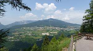
The comune territory borders the following municipalities: Caldonazzo, Centa San Nicolò, Besenello, Calliano, Lavarone, Lastebasse, Rovereto, Terragnolo and Laghi. It includes six main frazioni (Costa, Serrada, Guardia, Mezzomonte, San Sebastiano, Carbonare e Nosellari) and other of lesser size (Pont, Ondertol, Dori, Molino nuovo, Forreri, Ca nove, Molini, Peneri, Fontani, Scandelli, Sotto il soglio, Carpeneda, Mezzaselva, Erspameri, Francolini, Colpi, Nocchi, Perpruneri, Tezzeli, Morganti, Cùeli, Buse e Virti) in the valleys of Rio Cavallo and Astico.
It is a renowned ski resort, but it is also frequented in summer.
Points of interest
- Giardino Botanico Alpino di Passo Coe, an alpine nature preserve and botanical garden
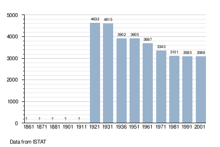
Demographic evolution
References