Palù del Fersina
| Palù del Fersina | ||
|---|---|---|
| Comune | ||
| Comune di Palù del Fersina | ||
| ||
 Palù del Fersina Location of Palù del Fersina in Trentino-Alto Adige/Südtirol  Palù del Fersina Palù del Fersina (Italy) | ||
| Coordinates: 46°8′N 11°21′E / 46.133°N 11.350°ECoordinates: 46°8′N 11°21′E / 46.133°N 11.350°E | ||
| Country | Italy | |
| Region | Trentino-Alto Adige/Südtirol | |
| Province | Trentino (TN) | |
| Area | ||
| • Total | 16.7 km2 (6.4 sq mi) | |
| Population (Dec. 2004) | ||
| • Total | 183 | |
| • Density | 11/km2 (28/sq mi) | |
| Time zone | UTC+1 (CET) | |
| • Summer (DST) | UTC+2 (CEST) | |
| Postal code | 38050 | |
| Dialing code | 0461 | |

the town of Palù del Fersina
Palù del Fersina (Mocheno: Palai/Palae en Bersntol, German: Palai im Fersental) is a comune (municipality) in Trentino in the northern Italian region Trentino-Alto Adige/Südtirol, located about 20 kilometres (12 mi) northeast of Trento. As of 31 December 2004, it had a population of 183 and an area of 16.7 square kilometres (6.4 sq mi).[1]
Palù del Fersina borders the following municipalities: Bedollo, Telve, Baselga di Pinè, Telve di Sopra, Sant'Orsola Terme, Fierozzo and Torcegno.
In the census of 2001, 184 inhabitants out of 195 (94.4%) declared themselves members of the Mócheno linguistic group.[2]
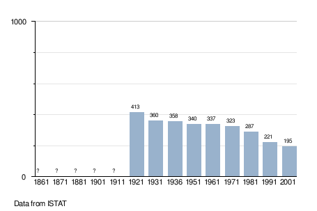
Demographic evolution
References
- ↑ All demographics and other statistics: Italian statistical institute Istat.
- ↑ "Tav. I.5 - Appartenenza alla popolazione di lingua ladina, mochena e cimbra, per comune di area di residenza (Censimento 2001)" (PDF). Annuario Statistico 2006 (in Italian). Autonomous Province of Trento. 2007. Retrieved 2011-05-12.

This article is issued from
Wikipedia.
The text is licensed under Creative Commons - Attribution - Sharealike.
Additional terms may apply for the media files.