Lavarone
| Lavarone Lafraun | ||
|---|---|---|
| Comune | ||
| Comune di Lavarone | ||
| ||
 Lavarone Lafraun Location of Lavarone Lafraun in Italy | ||
| Coordinates: 45°56′N 11°16′E / 45.933°N 11.267°ECoordinates: 45°56′N 11°16′E / 45.933°N 11.267°E | ||
| Country | Italy | |
| Region | Trentino-Südtirol | |
| Province | Trentino (TN) | |
| Frazioni | Chiesa, Cappella, Gionghi, Masetti, Villanova, Longhi, Magrè, Slaghenaufi, Bertoldi, Nicolussi, Piccoli, Oseli, Gasperi, Lanzino, Albertini, Rocchetti, Malga Laghetto, Stengheli, Azzolini, Masi di Sotto | |
| Government | ||
| • Mayor | Isacco Corradi | |
| Area | ||
| • Total | 26.3 km2 (10.2 sq mi) | |
| Elevation | 1,200 m (3,900 ft) | |
| Population (Dec. 2004) | ||
| • Total | 1,109 | |
| • Density | 42/km2 (110/sq mi) | |
| Demonym(s) | Lavaronesi | |
| Time zone | UTC+1 (CET) | |
| • Summer (DST) | UTC+2 (CEST) | |
| Postal code | 38040 | |
| Dialing code | 0464 | |
| Patron saint | San Floriano | |
| Website | Official website | |

Lavarone (German: Lafraun, Cimbrian: Lavròu) is a comune (municipality) in Trentino in the northern Italian region Trentino-Südtirol Tyrol–South Tyrol–Trentino Euroregion, located about 20 kilometres (12 mi) southeast of Trento. As of 31 December 2004, it had a population of 1,109 and an area of 26.3 square kilometres (10.2 sq mi).[1]
The municipality of Lavarone contains the frazioni (subdivisions): Chiesa, Cappella, Gionghi, Masetti, Villanova, Longhi, Magrè, Slaghenaufi, Bertoldi, Nicolussi, Piccoli, Oseli, Gasperi, Lanzino, Albertini, Rocchetti, Malga Laghetto, Stengheli, Azzolini and Masi di Sotto.
Lavarone borders the following municipalities: Caldonazzo, Luserna, Folgaria, Pedemonte, Levico Terme and Lastebasse.
Until the beginning of the 20th century the people of Lavarone spoke Cimbrian, an ancient German Bavarian dialect.
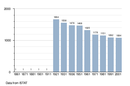
Demographic evolution
References
External links
![]()
- (in Italian) Homepage of the city