Campitello di Fassa
| Campitello di Fassa | |
|---|---|
| Comune | |
| Comune di Campitello di Fassa | |
.JPG) | |
 Campitello di Fassa Location of Campitello di Fassa in Italy | |
| Coordinates: 46°29′N 11°44′E / 46.483°N 11.733°ECoordinates: 46°29′N 11°44′E / 46.483°N 11.733°E | |
| Country | Italy |
| Region | Trentino-Alto Adige/Südtirol |
| Province | Trentino (TN) |
| Area | |
| • Total | 25.1 km2 (9.7 sq mi) |
| Elevation | 1,448 m (4,751 ft) |
| Population (Dec. 2004) | |
| • Total | 741 |
| • Density | 30/km2 (76/sq mi) |
| Time zone | UTC+1 (CET) |
| • Summer (DST) | UTC+2 (CEST) |
| Postal code | 38031 |
| Dialing code | 0462 |
Campitello di Fassa (Ladin: Ciampedèl, German: Kampidel im Fasstal) is a comune (municipality) in Trentino in the northern Italian region Trentino-Alto Adige/Südtirol, located about 70 kilometres (43 mi) northeast of Trento (100 km by road).
In the census of 2001, 625 inhabitants out of 732 (85.4%) declared Ladin as their native language.[1]
Geography
As of 31 December 2004, it had a population of 741 and an area of 25.1 square kilometres (9.7 sq mi).[2]
Campitello di Fassa borders the following municipalities: Santa Cristina Gherdëina, Sëlva, Kastelruth, Canazei, Tiers, and Mazzin.
Demographic evolution

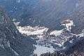 Campitello di Fassa (in front) and Fontanazzo (top right)
References
- ↑ "Tav. I.5 - Appartenenza alla popolazione di lingua ladina, mochena e cimbra, per comune di area di residenza (Censimento 2001)" (PDF). Annuario Statistico 2006 (in Italian). Autonomous Province of Trento. 2007. Retrieved 2011-05-12.
- ↑ All demographics and other statistics: Italian statistical institute Istat.

This article is issued from
Wikipedia.
The text is licensed under Creative Commons - Attribution - Sharealike.
Additional terms may apply for the media files.