Cinte Tesino
| Cinte Tesino | |
|---|---|
| Comune | |
| Comune di Cinte Tesino | |
 Cinte Tesino Location of Cinte Tesino in Italy | |
| Coordinates: 46°3′N 11°37′E / 46.050°N 11.617°ECoordinates: 46°3′N 11°37′E / 46.050°N 11.617°E | |
| Country | Italy |
| Region | Trentino-Alto Adige/Südtirol |
| Province | Trentino (TN) |
| Area | |
| • Total | 25.9 km2 (10.0 sq mi) |
| Population (Dec. 2004) | |
| • Total | 392 |
| • Density | 15/km2 (39/sq mi) |
| Time zone | UTC+1 (CET) |
| • Summer (DST) | UTC+2 (CEST) |
| Postal code | 38050 |
| Dialing code | 0461 |
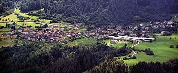
Cinte Tesino in spring
Cinte Tesino (German: Zint or Zinten) is a comune (municipality) in Trentino in the northern Italian region Trentino-Alto Adige/Südtirol, located about 40 kilometres (25 mi) east of Trento. As of 31 December 2004, it had a population of 392 and an area of 25.9 square kilometres (10.0 sq mi).[1]
Cinte Tesino borders the following municipalities: Canal San Bovo, Pieve Tesino, Castello Tesino, Scurelle, Lamon, Ospedaletto, and Grigno.
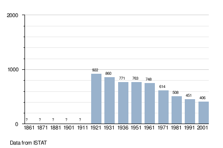
Demographic evolution
References

This article is issued from
Wikipedia.
The text is licensed under Creative Commons - Attribution - Sharealike.
Additional terms may apply for the media files.