Töss Valley
The Töss Valley (German: Tösstal) is a valley and a region of the canton of Zürich in Switzerland.
Geography
The valley embraces parts of the Zürcher Oberland including the districts of Hinwil, Pfäffikon and Winterthur, in addition to parts of the Zürcher Unterland (lower Töss valley).
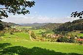
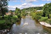
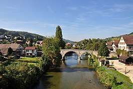
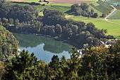
Usually Tösstal is the name of the upper Töss valley, i.e. its narrow, valley-like area in the southeast of the city of Winterthur. The river Töss rises at Tössstock mountain (el. 1,154 m) flows along the valley including the municipalities and villages of Steg, Lipperschwändi and Wellenau (villages of Fischenthal), Bauma, Juckern, Blitterswil, Saland, Tablat, Wila, Turbenthal, Zell, Rikon, Kollbrunn, and Sennhof near Winterthur. The Tösstal is a popular recreation area and well known for hiking tours in the surrounding mountains as Schnebelhorn and Hulftegg pass, and for skating and biking along Töss.
The lower Töss valley includes the widely flattened parts in the west of Winterthur; it compromises the quarters of Winterthur called Töss and Wülflingen, the municipalities Neftenbach, Pfungen, Dättlikon, Embrach, Rorbas, Freienstein and Teufen where the Töss joins the Rhine at Tössegg.
Transportation
The Tösstalstrasse (motorway) was built in 1837, the Tösstalbahn (S26) opened in 1872/76.
Literature
- Hans Bernhard: Wirtschafts- und Siedelungsgeographie des Tösstales. In: Jahresberichte der Geographisch-Ethnographischen Gesellschaft in Zürich, Vol. 11, 1910-1911 (Digitalisat)
- Kurt Hutter et al.: Das Tösstal. Birkenhalde Verlag, 2007. ISBN 978-3-905172-49-2.
External links
| Wikimedia Commons has media related to Tösstal. |