Gavilan Peak (Arizona)
| Gavilan Peak | |
|---|---|
 | |
| Highest point | |
| Elevation | 2,990 ft (911 m) NGVD 29[1] |
| Prominence | 730 ft (223 m) [1] |
| Coordinates | 33°54′25″N 112°07′27″W / 33.90698°N 112.1240455°WCoordinates: 33°54′25″N 112°07′27″W / 33.90698°N 112.1240455°W [2] |
| Geography | |
 Gavilan Peak | |
| Location | Maricopa County, Arizona, U.S. |
| Topo map | USGS Daisy Mountain |
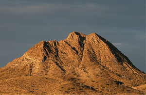
Gavilan Peak is northwest of Daisy Mountain, north of Anthem, Arizona and southeast of New River, Arizona. Considering its steepness, it is climbed much less frequently than Daisy Mountain. It was named in the 1880s, when the U.S. Cavalry and the Apaches fought a battle in the area. The name means 'sparrow hawk' in Spanish and 'hawk' in Apache.[2][3]
References
- 1 2 "Gavilan Peak AZ". ListsOfJohn.com. Retrieved 2016-08-16.
- 1 2 "Gavilan Peak". Geographic Names Information System. United States Geological Survey. Retrieved 2016-08-16.
- ↑ "Gavilan Peak, AZ". HikeArizona.com. Retrieved 2016-08-16.
This article is issued from
Wikipedia.
The text is licensed under Creative Commons - Attribution - Sharealike.
Additional terms may apply for the media files.