Tonto National Forest
| Tonto National Forest | |
|---|---|
 | |
 | |
| Location | Gila, Maricopa, Yavapai, and Pinal counties, Arizona, USA |
| Nearest city | Payson, Arizona |
| Coordinates | 33°50′40″N 111°17′04″W / 33.8443241°N 111.2845025°WCoordinates: 33°50′40″N 111°17′04″W / 33.8443241°N 111.2845025°W |
| Area | 2,873,200 acres (11,627 km2) |
| Established | 1905 |
| Visitors | 5,922,000 (in 2005) |
| Governing body | United States Forest Service |
| Website | Tonto National Forest |


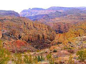
The Tonto National Forest, encompassing 2,873,200 acres (1,162,700 ha; 11,627 km2), is the largest of the six national forests in Arizona and is the fifth largest national forest in the United States.[1] The Tonto National Forest has diverse scenery, with elevations ranging from 1,400 feet (427 m) in the Sonoran Desert to 7,400 feet (2,256 m) in the ponderosa pine forests of the Mogollon Rim (pronounced MOH-gee-on, or MUH-gee-own). The Tonto National Forest is also the most visited "urban" forest in the United States.[2] The boundaries of the Tonto National Forest are the Phoenix metropolitan area to the south, the Mogollon Rim to the north and the San Carlos and Fort Apache Indian Reservation to the east. The Tonto (Spanish for "fool") is managed by the USDA Forest Service and its headquarters are in Phoenix. There are local ranger district offices in Globe, Mesa, Payson, Roosevelt, Scottsdale, and Young.[3]
Wildlife
Many wildlife species inhabit the forest including raccoons, bald eagles, black bears, coyotes, skunks, bobcats, roadrunners, prairie falcons, white-tailed deer, long-eared owls, mule deer, red-tailed hawks, Great blue herons, cougars, barn owls, ring-tailed cats, kestrels, pronghorns, javelinas, and elk.
Tonto Pass
Tonto National Forest began charging user fees in 1996 for daily and overnight stays at expanded amenity recreation sites in the national forest. Five different passes are currently offered for sale:
- Daily Tonto Pass $8
- Watercraft Sticker $4
- Annual Discovery Pass $80
- Annual Senior Discovery Pass $60
- Interagency Passes (prices and uses vary)
Tonto Passes are available through online vendors at the Tonto National Forest recreation passes and permits web page. Passes are also available through many local merchants.[1]
Lakes, rivers and streams
The Tonto National Forest has six notable cold water reservoirs:
The next four are created by the Salt River chain of dams:
- Saguaro Lake
- Canyon Lake
- Apache Lake
- Theodore Roosevelt Lake
Wilderness areas
There are eight federally designated wilderness areas within (or partially within) the Tonto National Forest:[4]
- Four Peaks Wilderness
- Hellsgate Wilderness
- Mazatzal Wilderness (partly in Coconino NF)
- Pine Mountain Wilderness (partly in Prescott NF)
- Salome Wilderness
- Salt River Canyon Wilderness
- Sierra Ancha
- Superstition Wilderness
A portion of the Verde Wild and Scenic River also lies within the forest.
History
The Tonto Forest Reserve was established on October 3, 1905 by the General Land Office. In 1906 the forest reserves were transferred to the U.S. Forest Service, and on March 4, 1907 Tonto became a National Forest. On January 13, 1908 the Pinal Mountains National Forest was added along with other lands. On July 1, 1908 part of Black Mesa National Forest and other lands were added, and on July 1, 1953 part of Crook National Forest was added.[5]
Proposed land transfer to Rio Tinto Group for copper mining
A land swap proposed as a part of the 2015 National Defense Authorization Act would permit a subsidiary of the Rio Tinto mining conglomerate, Resolution Copper Co., to acquire 2,400 acres of the Tonto National Forest, considered sacred for the San Carlos Apache Tribe, for purposes of copper mining. This proposal, in Section 3003, titled "Southeast Arizona Land Exchange", is strongly opposed by many Native Americans, including the 57 member tribes of The Affiliated Tribes of Northwest Indians, and by the Great Plains Tribal Chairmen’s Association.[6]
See also
- Fossil Creek
- List of U.S. National Forests
- Tonto National Monument, a National Park Service unit completely surrounded by Tonto National Forest
- Pinal Mountains
References
- 1 2 "Tonto National Forest". U.S. Forest Service, Tonto National Forest. Retrieved 8 December 2014.
- ↑ "Tonto National Forest – History and Development". fs.usda.gov. United States Forest Service. Retrieved 8 December 2014.
- ↑ USFS Ranger Districts by State
- ↑ "Wilderness maps". Wilderness.net. Retrieved 2012-06-22.
- ↑ Davis, Richard C. (September 29, 2005). "National Forests of the United States" (PDF). The Forest History Society. Archived (PDF) from the original on April 9, 2014.
- ↑ Toensing, Gale Courey (2014-12-12). "57 Affiliated Tribes of Northwest Indians Urge Senate to Nix Sacred Land Giveaway". Indian Country Today Media Network. Retrieved 2014-12-16.
External links
| Wikimedia Commons has media related to Tonto National Forest. |