Double Crater
| Double Crater | |
|---|---|
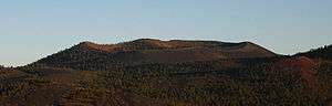 Double Crater, facing southeast. | |
| Highest point | |
| Elevation | 8,007 ft (2,441 m) [1] |
| Prominence | 944 ft (288 m) [1] |
| Coordinates | 35°20′34″N 111°26′52″W / 35.3427864°N 111.4476552°WCoordinates: 35°20′34″N 111°26′52″W / 35.3427864°N 111.4476552°W [2] |
| Geography | |
 Double Crater | |
| Location | Coconino County, Arizona, U.S. |
| Topo map | USGS Sunset Crater East |
| Geology | |
| Volcanic field | San Francisco volcanic field |
Double Crater is an extinct Pleistocene volcano within the San Francisco volcanic field, north of Flagstaff, Arizona.[3] It is to the southeast of Sunset Crater.
References
- 1 2 "Double Crater, Arizona". Peakbagger.com. Retrieved August 20, 2014.
- ↑ "Double Crater". Geographic Names Information System. United States Geological Survey. Retrieved August 20, 2014.
- ↑ Ulrich, G.E.; Billingsley, G.H.; Hereford, Richard; Wolfe, E.W.; Nealey, L.D.; Sutton, R.L. (1984). Map showing geology, structure, and uranium deposits of the Flagstaff 1 degrees x 2 degrees quadrangle, Arizona: (Map). 1:250000. Miscellaneous Investigations Series Map I-1446. U.S. Geological Survey.
This article is issued from
Wikipedia.
The text is licensed under Creative Commons - Attribution - Sharealike.
Additional terms may apply for the media files.