States and territories of Australia
| Australian states and territories | |
|---|---|
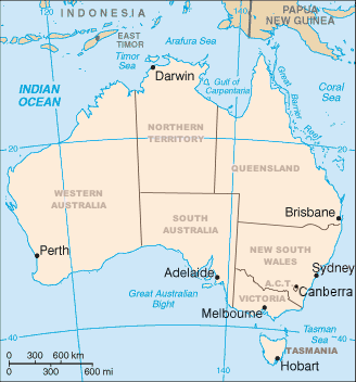 A clickable map of Australia's states, mainland territories and their capitals | |
| Category |
Federated states (6) Internal federal territories (3) External federal territories (7) |
| Location | Commonwealth of Australia |
| Populations | 0 (Ashmore and Cartier Islands, Heard and McDonald Islands) – 7,704,300 (New South Wales) |
| Areas | 10 km2 (3.9 sq mi) (Coral Sea Islands) – 5,896,500 km2 (2,276,700 sq mi) (Australian Antarctic Territory) |
| Subdivisions |
Local government areas Cadastral divisions |
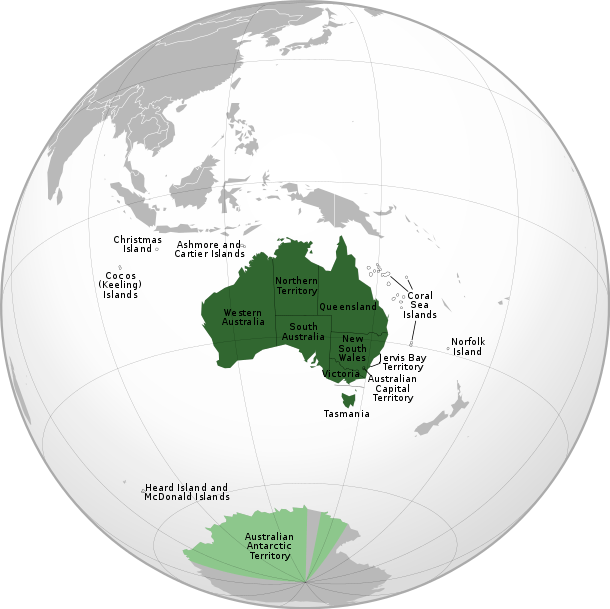
Australia (officially known as the Commonwealth of Australia) is a federation of six states, together with ten federal territories. The Australian mainland consists of five of the six federated states and three of the federal territories (the "internal" territories). The state of Tasmania is an island about 200 kilometres (120 mi) south of the mainland. The remaining seven territories are classified for some purposes as "external" territories. Aside from the Australian Antarctic Territory, which is Australia's claim to part of Antarctica, Australia is the world's sixth-largest country by total area.
All states and the two largest internal territories are partially self-governing, as well as being represented in the federal parliament; the other territories are administered by the federal government. Since 2015, federal control has also been extended to the formerly self-governing territory of Norfolk Island.[1] The third internal territory is the Jervis Bay Territory (JBT) which is on the coast of New South Wales south of Sydney and east of Canberra. Three of the external territories are inhabited; the others are uninhabited, apart from temporary-resident scientists.
Geographic Australia
The term geographic Australia is used by the Australian government to describe the area covered by demographic statistics such as national population figures. This area comprises Christmas Island and the Cocos (Keeling) Islands in addition to the six states and three mainland territories; Norfolk Island is the only territory with a permanent population that is not part of geographic Australia.[2]
States, territories, and external territories
| Administrative divisions of Australia |
|---|
| First level |
|
|
| Second level |
 |
| Flag | State/territory name | Abbrev | ISO[3] | Postal | Type | Capital (or largest settlement) |
Population[4][5] | Area (km²)[6] |
|---|---|---|---|---|---|---|---|---|
| New South Wales | NSW | AU-NSW | NSW | State | Sydney | 7,704,300 | 800,628 | |
| Queensland | Qld | AU-QLD | QLD | State | Brisbane | 4,827,000 | 1,723,936 | |
| South Australia | SA | AU-SA | SA | State | Adelaide | 1,706,500 | 978,810 | |
| Tasmania | Tas | AU-TAS | TAS | State | Hobart | 518,500 | 64,519 | |
| Victoria | Vic | AU-VIC | VIC | State | Melbourne | 6,039,100 | 227,010 | |
| Western Australia | WA | AU-WA | WA | State | Perth[n 2] | 2,613,700 | 2,526,786 | |
| Australian Capital Territory | ACT | AU-ACT | ACT | Territory | Canberra | 397,397 | 2,280 | |
| [n 3] | Jervis Bay Territory | JBT | JBT | Territory | (Jervis Bay Village) | 391 | 72 | |
| Northern Territory | NT | AU-NT | NT | Territory | Darwin | 244,000 | 1,335,742 | |
| [n 3] | Ashmore and Cartier Islands | External | (Offshore anchorage) | 0 | 199 | |||
| [n 3] | Australian Antarctic Territory | AAT | AQ[n 4] | External | Davis Station | 1,000[n 5] | 5,896,500 | |
| Christmas Island | CX | External[n 6] | Flying Fish Cove | 2,072 | 135 | |||
| Cocos (Keeling) Islands | CC | External[n 6] | West Island/Pulu Panjang | 596 | 14 | |||
| [n 3] | Coral Sea Islands | External | (Willis Island) | 4[n 7] | 10 | |||
| [n 3] | Heard Island and McDonald Islands | HIMI | HM | External | (Atlas Cove) | 0 | 372 | |
| Norfolk Island | NF | External | Kingston | 2,302 | 35 | |||
All states, (internal) territories and the external territory of Coral Sea Islands were part of Australia at federation and are constitutionally part of the Commonwealth. Northern Territory was part of South Australia, Australian Capital Territory and Jervis Bay Territory were part of New South Wales, and Coral Sea Islands was part of Queensland. Ashmore and Cartier Islands was accepted by Australia in 1934[7] and annexed to Northern Territory prior to the adoption of the Statute of Westminster in 1942 and, as such, is deemed to form part of Australia proper.
Cocos (Keeling) Islands voted for integration in 1984. Together with Christmas Island, Commonwealth laws apply automatically to the territory unless expressly stated otherwise[8] and residents of both external territories are associated with Northern Territory for federal elections. They are, thus, constitutionally part of Australia.
Uninhabited Heard and McDonald Island is treated as constitutionally part of Australia by the central government.[9]
The constitutional status of the Australian Antarctic Territory is unclear, with successive governments treating it either as a separate territory (as in the United Kingdom and Norway) or an integral part of the state (as in New Zealand and France). As of 2018, the present government appears to take the view that it is not constitutionally part of Australia.[10]
Norfolk Island's status is controversial, with the present (as of 2018) government taking measures to integrate the territory into Australia proper (including representation in parliament and compulsory voting). The Norfolk Islanders have not formally consented to this change in constitutional status and assert that they are not Australian.[11]
Proposed states
- Northern Australia, currently Northern Territory
Proposed external territories
- Lord Howe Island, currently part of New South Wales
- Macquarie Island, currently part of Tasmania
Defunct territories
Australia has had three now-defunct territories in its history:
- From 1926 to 1931, the Northern Territory was divided into Central Australia and North Australia, with the border at the 20th parallel south. Both territories were reincorporated as the Northern Territory at the end of this period.[12]
- From 1923 to 1968, the United Nations Trust Territory of Nauru was under Australian administration, until independence as the Republic of Nauru.
- From 1949 to 1975, the Territory of Papua and New Guinea was a territory of Australia, remaining so until the independence of the country of Papua New Guinea.
Background and overview
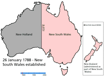
The states originated as separate British colonies prior to Federation in 1901. The Colony of New South Wales was founded in 1788 and originally comprised much of the Australian mainland, as well as Lord Howe Island, New Zealand, Norfolk Island, and Van Diemen's Land, in addition to the area currently referred to as the state of New South Wales. During the 19th century, large areas were successively separated to form the Colony of Tasmania (initially established as a separate colony named Van Diemen's Land in 1825), the Colony of Western Australia (initially established as the smaller Swan River Colony in 1829), the Province of South Australia (1836), the Colony of New Zealand (1840),[13] the Victoria Colony (1851) and the Colony of Queensland (1859). Upon Federation, the six colonies of New South Wales, Victoria, Queensland, South Australia, Western Australia, and Tasmania became the founding states of the new Commonwealth of Australia.
Legislative powers of the states are protected by the Australian constitution, section 107, and under the principle of federalism Commonwealth legislation only applies to the states where permitted by the constitution. The territories, by contrast, are from a constitutional perspective directly subject to the Commonwealth Government; laws for territories are determined by the Australian Parliament.[14]
Most of the territories are directly administered by the Commonwealth Government, while two (the Northern Territory and the Australian Capital Territory) have some degree of self-government although less than that of the states. In the self-governing territories, the Australian Parliament retains the full power to legislate, and can override laws made by the territorial institutions, which it has done on rare occasions. For the purposes of Australian (and joint Australia-New Zealand) intergovernmental bodies, the Northern Territory and the Australian Capital Territory are treated as if they were states.
Each state has a Governor, appointed by the Queen, which by convention she does on the advice of the state Premier. The Administrator of the Northern Territory, by contrast, is appointed by the Governor-General. The Australian Capital Territory has neither a Governor nor an Administrator, but the Governor-General exercises some powers that in other jurisdictions are exercised by the Governor of a state or Administrator of a territory, such as the power to dissolve the Legislative Assembly.
Jervis Bay Territory is the only non-self-governing internal territory. Until 1989, it was administered as if it were a part of the ACT, although it has always been a separate territory. Under the terms of the Jervis Bay Territory Acceptance Act 1915,[15] the laws of the ACT apply to the Jervis Bay Territory insofar as they are applicable and providing they are not inconsistent with an Ordinance.[16] Although residents of the Jervis Bay Territory are generally subject to laws made by the ACT Legislative Assembly, they are not represented in the Assembly. They are represented in the Parliament of Australia as part of the Electoral Division of Fraser in the ACT and by the ACT's two Senators. In other respects, the territory is administered directly by the Federal Government through the Territories portfolio.
The external territory of Norfolk Island possessed a degree of self-government from 1979 until 2015.
Each state has a bicameral parliament except Queensland, which abolished its upper house in 1922. The lower house is called the Legislative Assembly, except in South Australia and Tasmania, where it is called the House of Assembly. Tasmania is the only state to use proportional representation for elections to its lower house; all others elect members from single member constituencies, using preferential voting. The upper house is called the Legislative Council and is generally elected from multi-member constituencies using proportional representation. The three self-governing territories, the ACT, the Northern Territory, and Norfolk Island, each have unicameral Legislative Assemblies.
The head of government of each state is called the premier, appointed by the state's Governor. In normal circumstances, the Governor will appoint as premier whoever leads the party or coalition which exercises control of the lower house (in the case of Queensland, the only house) of the state Parliament. However, in times of constitutional crisis, the Governor can appoint someone else as Premier. The head of government of the self-governing internal territories is called the chief minister. The Northern Territory's chief minister, in normal circumstances whoever controls the Legislative Assembly, is appointed by the administrator.
Timeline
- 1788 – British Empire establishes Colony of New South Wales across central and eastern mainland Australia, the island of Tasmania, both islands of New Zealand and Norfolk Island.
- 1803 – The Coral Sea Islands are claimed by New South Wales
- 1825 – The island of Tasmania becomes the independent colony of Van Diemen's Land. New South Wales extends its borders further west in mainland Australia.
- 1829 – British Empire establishes Swan River Colony in western mainland Australia
- 1832 – Swan River Colony is renamed the colony of Western Australia
- 1841 – The islands of New Zealand become the independent colony of New Zealand. Much of eastern Antarctica is annexed by Britain as Victoria Land.
- 1844 – New South Wales transfers Norfolk Island to Van Diemen's Land
- 1846 – Northern central and eastern Australia briefly become the independent Colony of North Australia, then are returned to New South Wales.
- 1851 – Southeastern mainland Australia becomes the independent colony of Victoria
- 1856 – Van Diemen's Land is renamed the colony of Tasmania. Norfolk Island becomes the independent colony of Norfolk Island, however it is to be administered by the same Governor as New South Wales.
- 1857 – Much of southern central mainland Australia becomes the independent colony of South Australia. The Cocos (Keeling) Islands are annexed by Britain.
- 1859 – Northeastern mainland Australia and Coral Sea Islands become the independent colony of Queensland
- 1860 – A pocket of New South Wales territory remaining in southern central mainland Australia is transferred to South Australia
- 1862 – Some of New South Wales' northern central mainland Australian territory is transferred to Queensland
- 1863 – New South Wales' remaining northern central mainland Australian territory is transferred to South Australia
- 1878 – Britain annexes Ashmore Island
- 1883 – Queensland annexes southeastern New Guinea
- 1884 – Southeastern New Guinea becomes the independent Territory of Papua
- 1886 – The Cocos (Keeling) Islands are to be administered by the same Governor as the Straits Settlements
- 1888 – Christmas Island is annexed by Britain and incorporated into the Straits Settlements
- 1897 – Norfolk Island is officially reintegrated into New South Wales
- 1901 – New South Wales, Tasmania, Western Australia, Victoria and South Australia federate into the Commonwealth of Australia. Queensland transfers the Coral Sea Islands to the federal government, creating a federal external territory.
- 1902 – Britain transfers Papua to Australia as an external territory
- 1903 – The Cocos (Keeling) Islands are incorporated into the Straits Settlements
- 1909 – Britain annexes Cartier Island
- 1910 – Britain claims Heard Island and the McDonald Islands
- 1911 – The state of South Australia transfers control of northern central mainland Australia to the federal government, creating the Northern Territory. A small pocket of New South Wales around the city of Canberra is transferred to the federal government (who are seated within it), creating the Federal Capital Territory.
- 1913 – New South Wales transfers Norfolk Island to the federal government, making it a federal external territory
- 1915 – A small pocket of New South Wales around Jervis Bay is transferred to the federal government and incorporated into the Federal Capital Territory
- 1920 – Following the defeat of the German Empire in World War I, the League of Nations establishes an Australian mandate in northeastern New Guinea, it becomes the external Territory of New Guinea
- 1923 – Another conquered German territory, the island of Nauru, is established as an Australian mandate and external territory by the League of Nations, this time as a co-mandate with Britain and New Zealand
- 1927 – The Northern Territory is split into two territories – North Australia and Central Australia
- 1930 – Remaining territory in eastern Antarctica is annexed by Britain as Enderby Land
- 1931 – North Australia and Central Australia are reincorporated as the Northern Territory. Britain recognises Australia as possessors of the uninhabited Ashmore and Cartier Islands, making them an external federal territory.
- 1933 – Britain transfers Victoria Land and Enderby Land to Australia, creating the Australian Antarctic Territory, with ongoing limited international recognition
- 1938 – The Federal Capital Territory is renamed the Australian Capital Territory
- 1942 – The Japanese Empire conquers Nauru from Australia, Britain and New Zealand as part of World War II. Japan also conquers much of the Straits Settlements, including Christmas Island. The Cocos (Keeling) Islands are not conquered and are transferred to the Colony of Ceylong.
- 1946 – The United Nations, the successor to the League of Nations, renews its mandate of New Guinea to Australia
- 1947 – Following the defeat of Japan in World War II, the United Nations returns Nauru to Australia, Britain and New Zealand as a joint mandate. Christmas Island returns to Britain and is incorporated into the Colony of Singapore. The Cocos (Keeling) Islands are also transferred to Singapore.
- 1949 – Papua and New Guinea are incorporated into the singular Territory of Papua and New Guinea. Britain transfers Heard Island and the McDonald Islands to Australia, creating a federal external territory.
- 1955 – Britain transfers the Cocos (Keeling) Islands to Australia, they become an external territory
- 1958 – Britain transfers Christmas Island to Australia, it becomes an external territory
- 1966 – The Republic of Nauru is established, ending Australian/British/New Zealander control of the island
- 1975 – Papua and New Guinea becomes the Independent State of Papua New Guinea, ending British/Australian control
- 1989 – Jervis Bay becomes independent of the ACT, becoming the Jervis Bay Territory
- 2004 – The Coral Sea Islands declare independence from Australia as the Gay and Lesbian Kingdom of the Coral Sea Islands, with no international recognition, and declares war on Australia
Comparative terminology
| Entity | Type of entity | Tie to the Queen | Domestic administrator | Head of Government | Upper House of Parliament | Lower House of Parliament | Member of Parliament | |
|---|---|---|---|---|---|---|---|---|
| Upper house | Lower house[note 1] | |||||||
| Commonwealth of Australia | Federal government | Direct | Governor-General | Prime Minister | Senate | House of Representatives | Senator | MP |
| South Australia | Federated state | Direct (established by the Australia Act 1986) | Governor | Premier | Legislative Council | House of Assembly | MLC | MHA |
| Tasmania | ||||||||
| New South Wales | Legislative Assembly | MP | ||||||
| Victoria | MLA | |||||||
| Western Australia | ||||||||
| Queensland | N/A (abolished 1922) | N/A | MP | |||||
| Australian Capital Territory | Self-governing territory | Indirect (through Governor-General acting as "administrator") | Assembly and Chief minister | Chief minister | N/A | MLA | ||
| Northern Territory | Indirect (through Governor-General) | Administrator | ||||||
| Christmas Island | External territory | Mayor/shire president | Shire Council | Councillor | ||||
| Cocos (Keeling) Islands | ||||||||
| Norfolk Island | Regional Council[note 2] | |||||||
Note:
| ||||||||
Governors and administrators of states and territories
| Post | Incumbent | Appointed |
|---|---|---|
| Governor of New South Wales | His Excellency David Hurley | 2 October 2014 |
| Governor of Queensland | His Excellency Paul de Jersey | 29 July 2014 |
| Governor of South Australia | His Excellency Hieu Van Le | 1 September 2014 |
| Governor of Tasmania | Her Excellency Kate Warner | 10 December 2014 |
| Governor of Victoria | Her Excellency Linda Dessau | 1 July 2015 |
| Governor of Western Australia | His Excellency Kim Beazley | 1 May 2018 |
| Administrator of the Northern Territory | Her Honour Vicki O'Halloran | 31 October 2017 |
| Administrator of Norfolk Island | His Honour Eric Hutchinson | 1 April 2017 |
| Administrator of Australian Indian Ocean Territories (Christmas Island and Cocos (Keeling) Islands) |
Her Honour Natasha Griggs | 5 October 2017 |
Premiers and chief ministers of states and territories
| Post | Incumbent | Political party | Appointed |
|---|---|---|---|
| Premier of New South Wales | Gladys Berejiklian MP | Liberal | 23 January 2017 |
| Premier of Queensland | Annastacia Palaszczuk MP | Labor | 14 February 2015 |
| Premier of South Australia | Steven Marshall MHA | Liberal | 19 March 2018 |
| Premier of Tasmania | Will Hodgman MP | Liberal | 31 March 2014 |
| Premier of Victoria | Daniel Andrews MP | Labor | 4 December 2014 |
| Premier of Western Australia | Mark McGowan MLA | Labor | 17 March 2017 |
| Chief Minister of the Australian Capital Territory | Andrew Barr MLA | Labor | 11 December 2014 |
| Chief Minister of the Northern Territory | Michael Gunner MLA | Labor | 31 August 2016 |
| Mayor of Norfolk Island Council | Councillor Robin Adams | 6 July 2016 | |
| Presidents of Australian Indian Ocean Territories: |
Councillor Foo Kee Heng |
18 October 2011 |
State and territorial parliaments
State and territory supreme courts
- Supreme Court of the Australian Capital Territory
- Supreme Court of New South Wales
- Supreme Court of the Northern Territory
- Supreme Court of Queensland
- Supreme Court of South Australia
- Supreme Court of Tasmania
- Supreme Court of Victoria
- Supreme Court of Western Australia
- Supreme Court of Norfolk Island
State and territory police forces
State and territory borders
- Australian Capital Territory border
- New South Wales borders
- Northern Territory borders
- Queensland borders
- South Australian borders
- Tasmanian borders
- Victorian borders
- Western Australia border
Statistics
| State / territory | Abbreviation | Land area[6][17] |
|
Population density |
|
Notes | ||||||
|---|---|---|---|---|---|---|---|---|---|---|---|---|
| km2 | sq mi | Rank | Number | Rank | /km2 | /sq mi | Rank | % | Rank | |||
| ACT | 2,280 | 880 | 8 | 395,200 | 7 | 167.6 | 434 | 1 | 99.6% | 1 | [18] | |
| NSW | 800,628 | 309,124 | 5 | 7,704,300 | 1 | 9.62 | 24.9 | 3 | 63.0% | 5 | [19] | |
| NT | 1,335,742 | 515,733 | 3 | 244,000 | 8 | 0.18 | 0.47 | 8 | 54.0% | 6 | [20] | |
| QLD | 1,723,936 | 665,615 | 2 | 4,827,000 | 3 | 2.79 | 7.2 | 5 | 46.0% | 7 | [21] | |
| SA | 978,810 | 377,920 | 4 | 1,706,500 | 5 | 1.74 | 4.5 | 6 | 73.5% | 2 | [22] | |
| TAS | 64,519 | 24,911 | 7 | 518,500 | 6 | 7.58 | 19.6 | 4 | 41.0% | 8 | [23] | |
| VIC | 227,010 | 87,650 | 6 | 6,039,100 | 2 | 26.56 | 68.8 | 2 | 71.0% | 4 | [24] | |
| WA | 2,526,786 | 975,598 | 1 | 2,613,700 | 4 | 1.03 | 2.7 | 7 | 73.4% | 3 | [25] | |
Distance table
| Adelaide | |||||||||||||||
| 2673 | Albany | ||||||||||||||
| 1533 | 3588 | Alice Springs | |||||||||||||
| 1578 | 3633 | 443 | Uluru | ||||||||||||
| 2045 | 4349 | 3038 | 3254 | Brisbane | |||||||||||
| 2483 | 1943 | 2483 | 1223 | 3317 | Broome | ||||||||||
| 3352 | 5656 | 2457 | 2900 | 1716 | 2496 | Cairns | |||||||||
| 1196 | 3846 | 3706 | 2751 | 1261 | 3275 | 2568 | Canberra | ||||||||
| 3022 | 4614 | 1489 | 1932 | 3463 | 1803 | 2882 | 4195 | Darwin | |||||||
| 1001 | 3674 | 2534 | 2579 | 1944 | 3636 | 3251 | 918 | 4023 | Hobart | ||||||
| 3219 | 3787 | 1686 | 2129 | 3660 | 1045 | 3079 | 4392 | 827 | 4220 | Kununurra | |||||
| 2783 | 5087 | 2505 | 2948 | 976 | 2840 | 740 | 1999 | 2930 | 2682 | 3127 | Mackay | ||||
| 731 | 3404 | 2264 | 2309 | 1674 | 3124 | 2981 | 648 | 3753 | 609 | 3950 | 2412 | Melbourne | |||
| 2742 | 5106 | 1209 | 1652 | 1829 | 1834 | 1248 | 2561 | 1634 | 3075 | 1831 | 1296 | 2805 | Mount Isa | ||
| 2781 | 409 | 3696 | 3741 | 4457 | 2389 | 5764 | 3954 | 4205 | 3782 | 3378 | 5195 | 3512 | 4905 | Perth | |
| 1412 | 3970 | 3830 | 2875 | 1001 | 3373 | 2495 | 286 | 4034 | 1142 | 4516 | 1926 | 872 | 2400 | 4078 | Sydney |
Distance in kilometres from the corresponding city on the X-Y axis.
State and territory codes
| State/territory | Abbrev. | Call signs | Postal | Telephone numbers in Australia | Time zone | ||||
|---|---|---|---|---|---|---|---|---|---|
| AM/FM | TV | Amateur | Abbrev. | Postcode | Std | Summer | |||
| Australian Capital Territory | ACT | 1xx(x)[nb 1] | xx(x)Cn[nb 1] | VK1xx[nb 1] | ACT | 02nn,[nb 2] 26nn, 29nn | +61 2 62xx xxxx +61 2 61xx xxxx | +10 | +11 |
| New South Wales | NSW | 2xx(x) | xx(x)Nn | VK2xx | NSW | 1nnn,[nb 2] 2nnn | +61 2 xxxx xxxx[nb 3] | +10 (+9 1⁄2) | +11 |
| Victoria | Vic | 3xx(x) | xx(x)Vn | VK3xx | VIC | 3nnn, 8nnn[nb 2] | +61 3 xxxx xxxx[nb 3] | +10 | +11 |
| Queensland | Qld | 4xx(x) | xx(x)Qn | VK4xx | QLD | 4nnn, 9nnn[nb 2] | +61 7 xxxx xxxx | +10 | |
| South Australia | SA | 5xx(x) | xx(x)Sn | VK5xx | SA | 5nnn | +61 8 8xxx xxxx +61 8 7xxx xxxx | +9 1⁄2 | +10 1⁄2 |
| Western Australia | WA | 6xx(x) | xx(x)Wn | VK6xx | WA | 6nnn | +61 8 9xxx xxxx +61 8 6xxx xxxx | +8 | |
| Tasmania | Tas | 7xx(x) | xx(x)Tn | VK7xx | TAS | 7nnn | +61 3 6xxx xxxx | +10 | +11 |
| Northern Territory | NT | 8xx(x) | xx(x)Dn | VK8xx | NT | 08nn | +61 8 89xx xxxx | +9 1⁄2 | |
| External territories | |||||||||
| Norfolk Island | 2xx(x) | xx(x)Nn | VK2xx | NSW | 2899 | +672 3 xx xxx | +11 | ||
| Christmas Island | 6xx(x) | xx(x)Wn | VK9xx | WA | 6798 | +61 8 9164 xxxx | +7 | ||
| Cocos Island | 6xx(x) | xx(x)Wn | VK9xx | WA | 6799 | +61 8 9162 xxxx | +6 1⁄2 | ||
| Australian Antarctic Territory | AAT | none | VK0xx | TAS | +672 1 | +6 to +8 | |||
| Macquarie Island | none | +10 | +11 | ||||||
See also
- ISO 3166-2:AU, the ISO codes for the states and territories of Australia.
- Australian regional rivalries
- List of Australian demonyms
- List of proposed states of Australia
Notes
- ↑ Unless provided, references and details on data provided in the table can be found within the individual state and territory articles.
- ↑ Perth was defined as the capital by statute in 2016: City of Perth Act 2016 (WA) in AustLII.
- 1 2 3 4 5 The national

- ↑ Under the definitions in ISO 3166-1, the AAT is covered by the Antarctican ISO 3166-1 alpha-2 code "AQ".
- ↑ No permanent population, research station with fluctuating staff numbers.
- 1 2 Part of geographic Australia
- ↑ No permanent population, weather monitoring station generally with four staff.
References
- ↑ Strom, Marcus (1 June 2016). "Norfolk Island elects council that supports self-determination". The Sydney Morning Herald.
- ↑ Pink, Brian (2010). "Definition of Australia". Australian Standard Geographical Classification (ASGC) (Report). Australian Bureau of Statistics. p. 5.
- ↑ ISO 3166-2:AU (ISO 3166-2 codes for the states and territories of Australia)
- ↑ "3101.0 – Australian Demographic Statistics, Mar 2016". Australian Bureau of Statistics. 22 September 2016. Retrieved 1 November 2016.
- ↑ http://www.ga.gov.au/scientific-topics/national-location-information/dimensions/area-of-australia-states-and-territories
- 1 2 "Area of Australia – States and Territories". Geoscience Australia: National Location Information. Geoscience Australia. Retrieved 2 November 2016.
- ↑ https://www.legislation.gov.au/Details/C2008C00341
- ↑ https://www.alrc.gov.au/publications/alrc-80-legal-risk-international-transactions/10-external-territories
- ↑ http://heardisland.antarctica.gov.au/about/frequently-asked-questions
- ↑ http://www.antarctica.gov.au/about-antarctica/australia-in-antarctica/australian-antarctic-territory
- ↑ https://www.theguardian.com/australia-news/2015/may/21/were-not-australian-norfolk-islanders-adjust-to-shock-of-takeover-by-mainland
- ↑ Ling, Ted. "Dividing the Territory, 1926–31". Commonwealth Government Records about the Northern Territory. National Archives of Australia. Retrieved 28 September 2018.
- ↑ A.H. McLintock (ed), An Encyclopaedia of New Zealand, 3 vols, Wellington, NZ:R.E. Owen, Government Printer, 1966, vol 3 p. 526.'
- ↑ Constitution of Australia, section 122
- ↑ Jervis Bay Territory Acceptance Act 1915 (Cth).
- ↑ "Jervis Bay Territory Governance and Administration". The Department of Regional Australia, Local Government, Arts and Sport. Retrieved 17 January 2013.
Although the Jervis Bay Territory is not part of the Australian Capital Territory, the laws of the ACT apply, insofar as they are applicable and, providing they are not inconsistent with an Ordinance, in the Territory by virtue of the 'Jervis Bay Acceptance Act 1915'
- ↑ http://www.ga.gov.au/scientific-topics/national-location-information/dimensions/area-of-australia-states-and-territories
- ↑ Australian Bureau of Statistics (27 June 2017). "Australian Capital Territory". 2016 Census QuickStats. Retrieved 2 July 2017.

- ↑ Australian Bureau of Statistics (27 June 2017). "New South Wales". 2016 Census QuickStats. Retrieved 2 July 2017.
- ↑ Australian Bureau of Statistics (27 June 2017). "Northern Territory". 2016 Census QuickStats. Retrieved 2 July 2017.
- ↑ Australian Bureau of Statistics (27 June 2017). "Queensland". 2016 Census QuickStats. Retrieved 2 July 2017.
- ↑ Australian Bureau of Statistics (27 June 2017). "South Australia". 2016 Census QuickStats. Retrieved 2 July 2017.
- ↑ Australian Bureau of Statistics (27 June 2017). "Tasmania". 2016 Census QuickStats. Retrieved 2 July 2017.
- ↑ Australian Bureau of Statistics (27 June 2017). "Victoria". 2016 Census QuickStats. Retrieved 2 July 2017.
- ↑ Australian Bureau of Statistics (31 October 2012). "Western Australia". 2011 Census QuickStats. Retrieved 12 February 2013.
External links
Articles on first-level administrative divisions of Oceanian countries | |
|---|---|