Richmond Valley station
Richmond Valley | |||||||||||||||||||||||||||||||||||||||||||||||||||||||||||||||||||||||||||||||||||||||||||||||||
|---|---|---|---|---|---|---|---|---|---|---|---|---|---|---|---|---|---|---|---|---|---|---|---|---|---|---|---|---|---|---|---|---|---|---|---|---|---|---|---|---|---|---|---|---|---|---|---|---|---|---|---|---|---|---|---|---|---|---|---|---|---|---|---|---|---|---|---|---|---|---|---|---|---|---|---|---|---|---|---|---|---|---|---|---|---|---|---|---|---|---|---|---|---|---|---|---|---|
|
| |||||||||||||||||||||||||||||||||||||||||||||||||||||||||||||||||||||||||||||||||||||||||||||||||
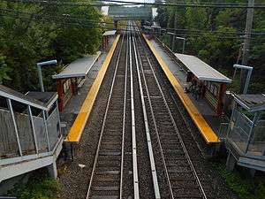 Richmond Valley station in August 2014, from the Champ Court overpass. | |||||||||||||||||||||||||||||||||||||||||||||||||||||||||||||||||||||||||||||||||||||||||||||||||
| Station statistics | |||||||||||||||||||||||||||||||||||||||||||||||||||||||||||||||||||||||||||||||||||||||||||||||||
| Address |
Richmond Valley Road & Amboy Road Staten Island, NY 10309 | ||||||||||||||||||||||||||||||||||||||||||||||||||||||||||||||||||||||||||||||||||||||||||||||||
| Borough | Staten Island | ||||||||||||||||||||||||||||||||||||||||||||||||||||||||||||||||||||||||||||||||||||||||||||||||
| Locale | Richmond Valley | ||||||||||||||||||||||||||||||||||||||||||||||||||||||||||||||||||||||||||||||||||||||||||||||||
| Coordinates | 40°31′11″N 74°13′45″W / 40.5196°N 74.2293°WCoordinates: 40°31′11″N 74°13′45″W / 40.5196°N 74.2293°W | ||||||||||||||||||||||||||||||||||||||||||||||||||||||||||||||||||||||||||||||||||||||||||||||||
| Services |
Local Express | ||||||||||||||||||||||||||||||||||||||||||||||||||||||||||||||||||||||||||||||||||||||||||||||||
| Transit connections |
| ||||||||||||||||||||||||||||||||||||||||||||||||||||||||||||||||||||||||||||||||||||||||||||||||
| Structure | Open-cut / At-grade | ||||||||||||||||||||||||||||||||||||||||||||||||||||||||||||||||||||||||||||||||||||||||||||||||
| Platforms | 2 side platforms | ||||||||||||||||||||||||||||||||||||||||||||||||||||||||||||||||||||||||||||||||||||||||||||||||
| Tracks | 2 | ||||||||||||||||||||||||||||||||||||||||||||||||||||||||||||||||||||||||||||||||||||||||||||||||
| Other information | |||||||||||||||||||||||||||||||||||||||||||||||||||||||||||||||||||||||||||||||||||||||||||||||||
| Opened | June 2, 1860[1] | ||||||||||||||||||||||||||||||||||||||||||||||||||||||||||||||||||||||||||||||||||||||||||||||||
| Station code | 519[2] | ||||||||||||||||||||||||||||||||||||||||||||||||||||||||||||||||||||||||||||||||||||||||||||||||
| Station succession | |||||||||||||||||||||||||||||||||||||||||||||||||||||||||||||||||||||||||||||||||||||||||||||||||
| Next north | Pleasant Plains | ||||||||||||||||||||||||||||||||||||||||||||||||||||||||||||||||||||||||||||||||||||||||||||||||
| Next south |
Arthur Kill Nassau (Closed) | ||||||||||||||||||||||||||||||||||||||||||||||||||||||||||||||||||||||||||||||||||||||||||||||||
| |||||||||||||||||||||||||||||||||||||||||||||||||||||||||||||||||||||||||||||||||||||||||||||||||
| |||||||||||||||||||||||||||||||||||||||||||||||||||||||||||||||||||||||||||||||||||||||||||||||||
| |||||||||||||||||||||||||||||||||||||||||||||||||||||||||||||||||||||||||||||||||||||||||||||||||


Richmond Valley is a Staten Island Railway station in the neighborhood of Richmond Valley, Staten Island, New York. Located at Richmond Valley Road and Amboy Road on the main line, the station is a mixture of open cut (below grade level) at the north end and grade level at the south end.
History
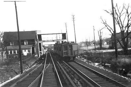
The station opened on June 2, 1860 with the opening of the Staten Island Railway (SIR) from Annadale to Tottenville.[1] The opening of the station gave the surrounding area a separate identity from Tottenville. While it had been considered part of Tottenville, it became its own neighborhood once the area was named Richmond Valley by the SIR.[3] The station consisted of a wooden stationhouse and a ticket office, which were located on the northbound platform, which was located to the south of the Richmond Valley Road grade crossing. However, the southbound platform was located to the north of the Richmond Valley Road.[4]
In 1940, the grade crossing at Richmond Valley Road was eliminated as the street was raised over the railroad tracks as part of a project to remove grade crossings across Staten Island.[4][5]
The platforms at the station were replaced in 1970.[6]
Under the 2015–2019 MTA Capital Plan, the station would undergo a complete overhaul and would be entirely closed for up to 6 months. Updates would include cellular service, Wi-Fi, charging stations, improved signage, and improved station lighting.[7][8] The station will feature many of the improvements made at the new Arthur Kill station, which is the next stop to the south.[9] As part of the overhaul, the station will have artwork installed as part of the MTA's Arts & Design program.[10] The project, which began on June 4, 2018, will repair the station's concrete structure, platforms, staircases, canopies and columns. The $2.2 million contract will be completed after ten months.[11][12]
West Shore Line
Directly to the south of the station, a non-electrified spur branched off of the Tottenville-bound track, which once ran all the way to the Arthur Kill. The spur was built in 1928 and was called West Shore Line by the Baltimore and Ohio Railroad (B&O), which owned the Staten Island Rapid Transit, in order to deliver building materials to the Outerbridge Crossing construction site near the Kill.[13] Years later, the track was used to serve a scrapyard owned by the Roselli Brothers.[14] Until 2013, the track remained intact to Page Avenue, with the right-of-way ballasted,[15] and with the switch in working condition to allow for trains to be stored, as evidenced by the fouling point sign.[16] However, that year, the connection was severed. The rails still exist past the old connection just to the west of the right-of-way.[17] Underneath Page Avenue, the track split into two other tracks, with the rails still in place.[18][19] The right-of-way for the line was an easement on the property of Nassau Metals, and was later used by CSX.[18]:1-2 Some sections of the old tracks have been removed, while others still remain in the overgrowth.[20]
Station layout
| G | Street level | Exit/Entrance |
| P Platforms |
Side platform, doors will open on the right for the first 3 cars only | |
| Southbound | ← Tottenville toward Tottenville (Arthur Kill) (Demolished: Nassau) | |
| Northbound | → St. George toward St. George (Pleasant Plains) → | |
| Side platform, doors will open on the right for the first 3 cars only | ||
There are two side platforms and the station is orange color with the south overpass appearing to be an addition during a renovation. Because of the short platform, only the first 3 cars in the direction of the train traveling can be platformed here. Mill Creek, which leads to the Arthur Kill, passes beneath part of the platform,[21] and travels underneath the SIR through a culvert.[20]
Exits
The station has exits on both its north and south ends. The north exit leads to Richmond Valley Road while the south exit leads to Amboy Road.[22]
References
- 1 2 Irvin Leigh and Paul Matus (December 23, 2001). "SIRT The Essential History". p. 5. Retrieved March 3, 2009.
- ↑ "Station Developers' Information". Metropolitan Transportation Authority. Retrieved June 13, 2017.
- ↑ "Ride the Staten Island Railway Through the Public Domain". The New York Public Library. Retrieved December 14, 2017.
- 1 2 "RICHMOND VALLEY HISTORY". www.tottenvillehistory.com. Retrieved December 14, 2017.
- ↑ Conrad, George (May 11, 1970). "Richmond Valley Station". nycsubway.org. Retrieved December 14, 2017.
- ↑ "Richmond Valley Station Platform: Staten Island Rapid Transit (SIRT)". nytm.pastperfectonline.com. Staten Island Rapid Transit Operating Authority. Retrieved December 14, 2017.
- ↑ "MTA Will Completely Close 30 Subway Stations For Months-Long "Revamp"". Gothamist. Archived from the original on August 1, 2016. Retrieved July 18, 2016.
- ↑ "MTAStations" (PDF). governor.ny.gov. Government of the State of New York. Retrieved July 18, 2016.
- ↑ "Richmond Valley SIR Station to be Revamped Under Cuomo's MTA Plan". DNAinfo New York. January 11, 2016. Archived from the original on December 15, 2017. Retrieved December 14, 2017.
- ↑ "MTA Arts & Design - MTA Staten Island Railroad - Richmond Valley Station". mtaarts.submittable.com. Metropolitan Transportation Authority. Retrieved December 14, 2017.
- ↑ "Repairs, Improvements Coming to Staten Island Railway's Richmond Valley Station". www.mta.info. Metropolitan Transportation Authority. June 3, 2018. Retrieved June 5, 2018.
- ↑ "Richmond Valley railway station undergoing $2.2M repair project". SILive.com. Retrieved 2018-06-13.
- ↑ NINTH ANNUAL REPORT DECEMBER 31, 1929 (PDF). PORT or NEW YORK Authority. 1929. p. 16.
- ↑ Pitanza, Marc (June 22, 2015). Staten Island Rapid Transit. Arcadia Publishing. p. 111. ISBN 9781439652039.
- ↑ Pitanza, Marc (January 28, 2007). "Ballasted Spur". nycsubway.org. Retrieved December 14, 2017.
- ↑ Pitanza, Marc (January 28, 2007). "Richmond Valley Spur". nycsubway.org. Retrieved December 14, 2017.
- ↑ Rosenfeld, Robbie (October 16, 2013). "Richmond Valley Spur". nycsubway.org. Retrieved December 14, 2017.
- 1 2 "236 Richmond Valley Road – Staten Island, New York Environmental Assessment Statement – Analyses" (PDF). Department of City Planning. August 29, 2014. Retrieved December 14, 2017.
- ↑ Pitanza, Marc (January 28, 2007). "Page Avenue Switch". nycsubway.org. Retrieved December 14, 2017.
- 1 2 Kensinger, Nathan (June 23, 2016). "Exploring Staten Island's changing Mill Creek". Curbed NY. Retrieved December 14, 2017.
- ↑ Rosenfeld, Robbie (October 16, 2013). "Mill Creek at Richmond Valley Station". nycsubway.org. Retrieved December 14, 2017.
- ↑ "Map of NYC Subway Entrances". NYC Open Data. City of New York. Retrieved July 10, 2018.
External links
![]()