Atlantic station (Staten Island Railway)
Atlantic | ||||||||||||||||||||||||||||||||||||||||||||||||||||||||||||||||||||||||||
|---|---|---|---|---|---|---|---|---|---|---|---|---|---|---|---|---|---|---|---|---|---|---|---|---|---|---|---|---|---|---|---|---|---|---|---|---|---|---|---|---|---|---|---|---|---|---|---|---|---|---|---|---|---|---|---|---|---|---|---|---|---|---|---|---|---|---|---|---|---|---|---|---|---|---|
| Former Staten Island Railway station | ||||||||||||||||||||||||||||||||||||||||||||||||||||||||||||||||||||||||||
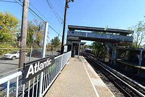 A view of the station prior to its demolition. | ||||||||||||||||||||||||||||||||||||||||||||||||||||||||||||||||||||||||||
| Station statistics | ||||||||||||||||||||||||||||||||||||||||||||||||||||||||||||||||||||||||||
| Address |
Arthur Kill Road & Tracy Avenue Staten Island, NY 10307 | |||||||||||||||||||||||||||||||||||||||||||||||||||||||||||||||||||||||||
| Borough | Staten Island | |||||||||||||||||||||||||||||||||||||||||||||||||||||||||||||||||||||||||
| Locale | Tottenville | |||||||||||||||||||||||||||||||||||||||||||||||||||||||||||||||||||||||||
| Coordinates | 40°30′56″N 74°14′45″W / 40.51542°N 74.2457°WCoordinates: 40°30′56″N 74°14′45″W / 40.51542°N 74.2457°W | |||||||||||||||||||||||||||||||||||||||||||||||||||||||||||||||||||||||||
| Services | None (demolished) | |||||||||||||||||||||||||||||||||||||||||||||||||||||||||||||||||||||||||
| Structure | At-grade | |||||||||||||||||||||||||||||||||||||||||||||||||||||||||||||||||||||||||
| Platforms | 2 side platforms | |||||||||||||||||||||||||||||||||||||||||||||||||||||||||||||||||||||||||
| Tracks | 2 | |||||||||||||||||||||||||||||||||||||||||||||||||||||||||||||||||||||||||
| Other information | ||||||||||||||||||||||||||||||||||||||||||||||||||||||||||||||||||||||||||
| Opened | c.1909[1]-1911[2] | |||||||||||||||||||||||||||||||||||||||||||||||||||||||||||||||||||||||||
| Closed | January 21, 2017[3] | |||||||||||||||||||||||||||||||||||||||||||||||||||||||||||||||||||||||||
| Station code | 521[4] | |||||||||||||||||||||||||||||||||||||||||||||||||||||||||||||||||||||||||
| Station succession | ||||||||||||||||||||||||||||||||||||||||||||||||||||||||||||||||||||||||||
| Next north | Arthur Kill | |||||||||||||||||||||||||||||||||||||||||||||||||||||||||||||||||||||||||
| Next south | Tottenville | |||||||||||||||||||||||||||||||||||||||||||||||||||||||||||||||||||||||||
| ||||||||||||||||||||||||||||||||||||||||||||||||||||||||||||||||||||||||||
| ||||||||||||||||||||||||||||||||||||||||||||||||||||||||||||||||||||||||||
| ||||||||||||||||||||||||||||||||||||||||||||||||||||||||||||||||||||||||||


Atlantic was a Staten Island Railway station in the neighborhood of Tottenville, Staten Island, New York. With the condition of the station having deteriorated after the 1990s, this station, and the Nassau station to the north, were replaced by a new station at Arthur Kill Road. When that station opened in January 2017, Atlantic station was closed and subsequently demolished.
History
The station's exact opening date is not certain, but it is known that the station opened between 1909[1] and 1911.[2] The station was primarily built to serve the workers of the former Atlantic Terra Cotta factory, from where the station name originated.[5] The pedestrian overpass was built in the 1930s. There used to be a grade crossing adjacent to the station, and at least until the 1970s, a small shanty that protected it still existed.[6]
The Metropolitan Transportation Authority purchased and gained control of the Staten Island Rapid Transit in 1971, and started to modernize the rail line. The stations on the line were modernized again in the 1990s, with the exception of Atlantic, and the nearby Nassau station, which also was built to serve a factory. As a result, these two stations were the only visual remains of a time when the SIRT built new platforms in the 1960s during a multi-phase grade elimination project farther north but without adding new canopies or shelters at these stops. Instead, these two stations were set to be replaced with a new ADA-accessible station in between the two at Arthur Kill Road.[7][7][3] However, the funds required for the construction of the project were not available, pushing back the construction of the project to 2013. In the mean time, with the lack of maintenance, the platform extension deteriorated, forcing the MTA to close the platform extensions on September 2, 2010.[8][9][10] Construction on the replacement Arthur Kill station commenced in October 2013,[11][8][12][10] and after several delays was opened on January 21, 2017.[13] Once the new station opened, Atlantic closed, and in May 2017, it was demolished.[14][15]
Station layout
| M | - | Crossover between platforms |
| P Platform level |
Side platform, demolished | |
| Southbound | ← Tottenville does not stop here (Tottenville) | |
| Northbound | → St. George does not stop here (Arthur Kill) → | |
| Side platform, demolished | ||
| G | Ground Level | Exits/Entrances |
Located roughly at Fisher Avenue and Arthur Kill Road on the main line, it was at grade level with side platforms approximately 80 feet (24 m) long that could hold only one car.[16][17] Former operations before the station closed only had the last car stop at the platform. Prior to its demolition, the station still had pre-1990s SIRT station components—steel corrugated walls, overpasses and original 4-foot (1.2 m)-high station pipe railings with faded signs.
Exits
Access to the northbound platform was via the short dead-end Tracy Avenue off of Arthur Kill Road between Fisher and Wood Avenues, while the southbound platform was reached from an entrance on Ellis Street. An overpass linked both platforms. The overpass is still accessible, but the stairways leading down to the platform were demolished along with the station.[18]
References
- 1 2 Minn, Michael (December 18, 2009). "History and Future of the North Shore Rail Line on Staten Island" (PDF). michaelminn.net. Retrieved August 1, 2015.
- 1 2
- "1911, 1912, and 1913 SIRT Timetables". Flickr. Retrieved March 24, 2017.
- "1911, 1912, and 1913 SIRT Timetables". Flickr. Retrieved March 24, 2017.
- 1 2 "Untitled Document". Retrieved October 30, 2015.
- ↑ "Station Developers' Information". Metropolitan Transportation Authority. Retrieved June 13, 2017.
- ↑ Stein, Mark D. (September 27, 2012). "It's official: New Staten Island Railway access for Tottenville". SILive.com. Staten Island. New York: Staten Island Advance. Retrieved July 28, 2015.
- ↑ Pitanza, Marc (2015). Staten Island Rapid Transit Images of Rail. Arcadia Publishing. ISBN 978-1-4671-2338-9.
- 1 2 "STATEN ISLAND RAILWAY". forgotten-ny.com. July 20, 1999. Retrieved December 17, 2017.
- 1 2 "Partial Closure of the Staten Island Railway Nassau Station" (Press release). MTA New York City Transit. August 30, 2010. Retrieved January 4, 2015.
- ↑ Yates, Maura (September 1, 2010). "Nassau S.I. Railway station platform gets shorter". Staten Island Advance. Archived from the original on September 3, 2010. Retrieved October 30, 2015.
- 1 2 "Groundbreaking for New MTA Staten Island Railway Arthur Kill Station in Tottenville". Metropolitan Transportation Authority. October 18, 2013. Retrieved January 21, 2017.
- ↑ [1]
- ↑ Stein, Mark D. (September 27, 2012). "It's official: New Staten Island Railway access for Tottenville". Staten Island Advance. Retrieved July 28, 2015.
- ↑ "New Arthur Kill Station". Metropolitan Transportation Authority. January 20, 2017. Retrieved January 20, 2017.
- ↑ "Capital Program Oversight Committee Meeting June 2016" (PDF). Metropolitan Transportation Authority. June 17, 2016. Retrieved June 17, 2016.
- ↑ "Capital Program Oversight Committee Meeting July 2017" (PDF). mta.info. Metropolitan Transportation Authority. July 24, 2017. p. 88. Retrieved December 17, 2017.
- ↑ "Partial Closure of the Staten Island Railway Nassau Station" (Press release). MTA New York City Transit. August 30, 2010. Retrieved January 4, 2015.
- ↑ "MTA | news | Groundbreaking for New MTA Staten Island Railway Arthur Kill Station in Tottenville". mta.info. Metropolitan Transportation Authority. October 18, 2013. Retrieved January 21, 2017.
- ↑ "Map of NYC Subway Entrances". NYC Open Data. City of New York. Retrieved July 10, 2018.
External links
| Wikimedia Commons has media related to Atlantic (Staten Island Railway station). |