Speers, Pennsylvania
| Speers | |
|---|---|
| Borough | |
 | |
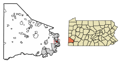 Location of Speers in Washington County, Pennsylvania. | |
 Speers Location of Speers in Pennsylvania | |
| Coordinates: 40°7′20″N 79°52′50″W / 40.12222°N 79.88056°WCoordinates: 40°7′20″N 79°52′50″W / 40.12222°N 79.88056°W | |
| Country | United States |
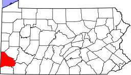
| State | Pennsylvania |
| County | Washington |
| Established | 1860 |
| Government | |
| • Mayor | William R. Lee |
| Area[1] | |
| • Total | 1.09 sq mi (2.83 km2) |
| • Land | 0.97 sq mi (2.51 km2) |
| • Water | 0.12 sq mi (0.32 km2) |
| Population (2010) | |
| • Total | 1,154 |
| • Estimate (2016)[2] | 1,123 |
| • Density | 1,158.93/sq mi (447.64/km2) |
| Time zone | UTC-4 (EST) |
| • Summer (DST) | UTC-5 (EDT) |
| Area code(s) | 724 |
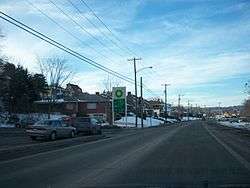
Speers is a borough in Washington County, Pennsylvania, United States. The population was 1,123 at the 2016 census [3] .
Geography
According to the United States Census Bureau, the Borough of Speers has a total area of 1.1 square miles (2.8 km2), of which, 1.0 square mile (2.6 km2) of it is land and 0.1 square miles (0.26 km2) of it (11.01%) is water [4].
Surrounding and adjacent neighborhoods
Speers has four land borders with Dunlevy to the southeast, Long Branch to the south-southeast, Twilight from the south to the west, and Charleroi to the northwest. Across the Monongahela River, Speers runs adjacent with Rostraver in Westmoreland County and Belle Vernon in Fayette County, the former connected by the Belle Vernon Bridge over I-70.
Demographics
| Historical population | |||
|---|---|---|---|
| Census | Pop. | %± | |
| 1900 | 369 | — | |
| 1910 | 383 | 3.8% | |
| 1920 | 435 | 13.6% | |
| 1930 | 654 | 50.3% | |
| 1940 | 852 | 30.3% | |
| 1950 | 1,089 | 27.8% | |
| 1960 | 1,479 | 35.8% | |
| 1970 | 1,408 | −4.8% | |
| 1980 | 1,425 | 1.2% | |
| 1990 | 1,284 | −9.9% | |
| 2000 | 1,241 | −3.3% | |
| 2010 | 1,154 | −7.0% | |
| Est. 2016 | 1,123 | [2] | −2.7% |
| Sources:[5][6][7] | |||
As of the census[6] of 2000, there were 1,241 people, 538 households, and 381 families residing in the borough. The population density was 1,285.0 people per square mile (494.0/km²). There were 561 housing units at an average density of 580.9 per square mile (223.3/km²). The racial makeup of the borough was 97.66% White, 0.73% African American, 1.29% Asian, and 0.32% from two or more races. Hispanic or Latino of any race were 0.24% of the population.
There were 538 households out of which 23.6% had children under the age of 18 living with them, 59.5% were married couples living together, 9.3% had a female householder with no husband present, and 29.0% were non-families. 27.3% of all households were made up of individuals and 16.2% had someone living alone who was 65 years of age or older. The average household size was 2.31 and the average family size was 2.80.
In the borough the population was spread out with 17.7% under the age of 18, 6.0% from 18 to 24, 22.2% from 25 to 44, 27.4% from 45 to 64, and 26.7% who were 65 years of age or older. The median age was 47 years. For every 100 females, there were 91.2 males. For every 100 females age 18 and over, there were 89.1 males.
The median income for a household in the borough was $40,500, and the median income for a family was $48,173. Males had a median income of $37,188 versus $30,536 for females. The per capita income for the borough was $20,446. About 5.0% of families and 7.7% of the population were below the poverty line, including 17.3% of those under age 18 and 6.6% of those age 65 or over.
References
- Notes
- ↑ "2016 U.S. Gazetteer Files". United States Census Bureau. Retrieved Aug 14, 2017.
- 1 2 "Population and Housing Unit Estimates". Retrieved June 9, 2017.
- ↑ "United States Census Bureau".
- ↑ "PA Townlocator".
- ↑ "Census of Population and Housing". U.S. Census Bureau. Retrieved 11 December 2013.
- 1 2 "American FactFinder". United States Census Bureau. Retrieved 2008-01-31.
- ↑ "Incorporated Places and Minor Civil Divisions Datasets: Subcounty Resident Population Estimates: April 1, 2010 to July 1, 2012". Population Estimates. U.S. Census Bureau. Archived from the original on 17 June 2013. Retrieved 11 December 2013.
| Counties |  Map of the Pittsburgh Tri-State with green counties in the metropolitan area and yellow counties in the combined area. | |
|---|---|---|
| Major cities | ||
| Cities and towns 15k-50k (in 2010) | ||
| Airports | ||
| Topics | ||
| ||