Skenderaj
| Skenderaj Skenderaj or Skënderaj (Albanian) Србица/Srbica (Serbian) | |
|---|---|
| Town and municipality | |
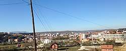 Panoramic view of Skenderaj in autumn | |
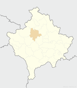 Location of the municipality of Skenderaj within Kosovo | |
 Skenderaj Location of the municipality of Skenderaj within Kosovo | |
| Coordinates: 42°44′N 20°47′E / 42.733°N 20.783°E | |
| Country | Kosovo[lower-alpha 1] |
| District | District of Mitrovica |
| Government | |
| • Mayor | Bekim Jashari |
| • Municipal | 374 km2 (144 sq mi) |
| Elevation | 620 m (2,030 ft) |
| Population (2011) | |
| • Urban | 9,372 |
| • Municipal | 50,858 |
| • Municipal density | 140/km2 (350/sq mi) |
| Time zone | UTC+1 (CET) |
| • Summer (DST) | UTC+2 (CEST) |
| Postal code | 41000 |
| Area code(s) | +383 28 |
| Car plates | 02 |
| Website |
kk |
Skenderaj (Albanian: Skënderaj) or Srbica (Serbian Cyrillic: Србица), is a town and municipality located in the Mitrovica District of Kosovo[lower-alpha 1]. According to the 2011 census, the town of Skenderaj has 9,372 inhabitants, while the municipality has 50,858 inhabitants.
It is the largest city in the Drenica geographical region of Kosovo.[1] It is solely populated by Albanians. It is claimed to be the poorest city in Kosovo. It is the place where the Kosovo War began in 1998, and to which the most damage was done.[1]
Geography
The settlement is by the Klina river, in the Klina field (Klinsko polje).[2] It is the main settlement of the Drenica region.[2] The Klina river belongs to the Metohija region, while the settlement morphologically and hydrologically gravitates towards the Kosovo region.[2]
The municipality covers an area of 378 km2, including the town of Skenderaj and 51 villages.
History
Archaeological findings in the municipality area include a Neolithic site in Rudnik,[3] and remains of a Roman necropolis in Gornji Obilić.[4] The municipality cadastral area includes several settlements that existed during the Middle Ages, among which some exist still today, such as Leočina, Poljance, Banja, and others.[5] There are ruins of a church dating to the 14th century in southern Leočina.[6] The Church of St. Nicholas was built in 1436, in Banja, as the endowment of Serbian magnate Rodop.[7] The Devič monastery was built in Lauša near Srbica in the 15th century, dedicated to the local monk, St. Joanikije (d. 1430).[8] The Church of St. John was built in the 16th century on the ruins of a 14th-century church, in Leočina; the church is surrounded by an old and large Serbian graveyard with tombs dating to the 17th–19th centuries.[9] A 16th-century church and cemetery is located in Rudnik.[10]
The town (varoš) itself was established as Srbica in 1924.[11][2] It had 30 houses inhabited by Serbs and Montenegrins.
In the early 20th century Albanian resistance began with the Kachak movement led by Azem Bejta and his wife Shote Galica, who fought against Bulgarian, Austro-Hungarian and Yugoslav forces.[12] At the end of World War II in 1944, the leader of the Drenica Brigade Shaban Polluzha refused to lead his 12,000 men north and join the Partisans in order to pursue the retreating Germans, because Serbian Chetnik groups were attacking the Albanian population in Kosovo.[13]
Economy
Skenderaj has historically been the poorest municipality in Kosovo, with little investment having been made since the time of the former Yugoslavia. It suffers from low economic activity and continuous high unemployment. Agriculture is the major local industry but the municipality has not fully developed existing arable land. Today, the local economy consists of small enterprises such as family-run shops and restaurants while two privatized factories, a brick and a flour mill, employ a few hundred people. The other major sector of employment is the municipality’s civil service.[1]
Sport
Skënderaj is home of the Kosovar Superliga football club KF Drenica.[1] which plays their home games in the Bajram Aliu Stadium. Skënderaj is also home of the Kosovar Superliga volleyball club KV Skenderaj women's and KV Drenica men's.
Cultural heritage
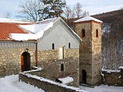
- Devič, Serbian Orthodox abbey
Demographics
| Municipal historical population | ||
|---|---|---|
| Year | Pop. | ±% p.a. |
| 1948 | 23,744 | — |
| 1953 | 26,166 | +1.96% |
| 1961 | 30,308 | +1.85% |
| 1971 | 36,660 | +1.92% |
| 1981 | 46,927 | +2.50% |
| 1991 | 55,471 | +1.69% |
| 2011 | 50,858 | −0.43% |
| 2016 est. | 51,746 | +0.35% |
| Source: Division of Kosovo | ||
According to the last official census done in 2011, the municipality of Skenderaj has 50,858 inhabitants.
Ethnic groups
The ethnic composition of the municipality:
| Ethnic group | 1991 census | 2011 census |
|---|---|---|
| Albanians | 54,437 | 50,685 |
| Serbs | 713 | 50 |
| Bosniaks | - | 42 |
| Ashkali and Egyptians | 37 | 11 |
| Others | - | 70 |
| Total | 55,187 | 50,858 |
Notable people
- Adem Jashari, Kosovo Liberation Army leader, born in Prekaz
- Hashim Thaçi, President of Kosovo (2016–present)
- Hamëz Jashari, co-founder of KLA and brother of Adem Jashari
- Hasan Prishtina, political leader of Albanian National Movement
- Sylejman Selimi, comrade of Jashari
- Shote Galica, Kachak leader
- Përparim Hetemaj, footballer
- Mehmet Hetemaj, footballer
- Ahmet Delia, activist of League of Prizren
See also
Notes and references
- Notes
- 1 2 Kosovo is the subject of a territorial dispute between the Republic of Kosovo and the Republic of Serbia. The Republic of Kosovo unilaterally declared independence on 17 February 2008, but Serbia continues to claim it as part of its own sovereign territory. The two governments began to normalise relations in 2013, as part of the Brussels Agreement. Kosovo has received formal recognition as an independent state from 113 out of 193 United Nations member states.
- References
- Radovanović, Milovan (2004). Etnički i demografski procesi na Kosovu i Metohiji. Liber Press.
- Marković, Jovan Đ. (1967). Geografske oblasti Socijalističke Federativne Republike Jugoslavije. Zavod za izdavanje udžbenika Socijalističke Republike Srbije.
- 1 2 3 4 OSCE Municipal Profile, April 2008
- 1 2 3 4 Marković 1967, p. 407.
- ↑ "Праисторијски археолошки локалитет". Споменици културе у Србији.
- ↑ "Остаци римске некрополе". Споменици културе у Србији.
- ↑ Božanić, S. (2009). "O zemljišnim međama srpskog srednjovekovnog sela" (PDF). Istraživanja, no. 20: 47–64.
- ↑ "Преобрашка-Калуђерска црква". Споменици културе у Србији.
- ↑ "Црква Св. Николе". Споменици културе у Србији.
- ↑ "Манастир Девич у близини Србице". Споменици културе у Србији.
- ↑ "Црква Св. Јована". Споменици културе у Србији.
- ↑ "Црква Св. Ђорђа са гробљем". Споменици културе у Србији.
- ↑ Radovanović 2004, p. 318.
- ↑ Elsie, Robert (2004). Historical Dictionary of Kosova. The Scarecrow Press. p. 63. ISBN 0-8108-5309-4.
- ↑ Robert Elsie (1 December 2010). Historical Dictionary of Kosovo. Scarecrow Press. p. 219. ISBN 978-0-8108-7231-8. Retrieved 30 August 2012.
External links
| Wikimedia Commons has media related to Srbica/Skënderaj. |
| Ferizaj District |  | |
|---|---|---|
| Gjakova District | ||
| Gjilan District | ||
| Mitrovica District | ||
| Peć District | ||
| Pristina District | ||
| Prizren District | ||
1 Kosovo is the subject of a territorial dispute between the Republic of Kosovo and the Republic of Serbia. The Republic of Kosovo unilaterally declared independence on 17 February 2008, but Serbia continues to claim it as part of its own sovereign territory. The two governments began to normalise relations in 2013, as part of the Brussels Agreement. Kosovo has received formal recognition as an independent state from 113 out of 193 United Nations member states. | ||
Coordinates: 42°44′48″N 20°47′19″E / 42.74667°N 20.78861°E