London Borough of Redbridge
| London Borough of Redbridge | |||
|---|---|---|---|
| London borough | |||
| |||
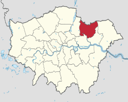 Redbridge shown within Greater London | |||
| Sovereign state | United Kingdom | ||
| Constituent country | England | ||
| Region | London | ||
| Ceremonial county | Greater London | ||
| Created | 1 April 1965 | ||
| Admin HQ | Ilford | ||
| Government | |||
| • Type | London borough council | ||
| • Body | Redbridge London Borough Council | ||
| • Leadership |
Leader & Cabinet Leader, Cllr Jas Athwal Deputy, Cllr Elaine Norman (Labour) | ||
| • Mayor | Cllr Debbie Kaur-Thiara | ||
| • London Assembly | Keith Prince (CON) AM for Havering and Redbridge | ||
| • MPs |
John Cryer (LAB) Iain Duncan Smith (CON) Mike Gapes (LAB) Wes Streeting (LAB) | ||
| • EU Parliament | London | ||
| Area | |||
| • Total | 56.41 km2 (21.78 sq mi) | ||
| Area rank | 263rd (of 326) | ||
| Population (mid-2017 est.) | |||
| • Total | 301,800 | ||
| • Rank | 38th (of 326) | ||
| • Density | 5,400/km2 (14,000/sq mi) | ||
| • Ethnicity[1] |
34.5% White British | ||
| Time zone | UTC (GMT) | ||
| • Summer (DST) | UTC+1 (BST) | ||
| Postcodes | E, IG, RM | ||
| Area code(s) | 020 | ||
| ONS code | 00BC | ||
| GSS code | E09000026 | ||
| Police | Metropolitan Police | ||
| Website | www.redbridge.gov.uk/ | ||
The London Borough of Redbridge is a London borough in East London, England.[2]
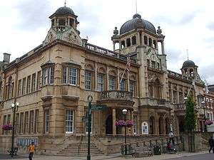
Its administrative headquarters is at Redbridge Town Hall in Ilford. The local authority is Redbridge London Borough Council.
Etymology
The name comes from a bridge over the River Roding which was demolished in 1921. The bridge was made of red brick, unlike other bridges in the area made of white stone. The name had first been applied to the Redbridge area and Redbridge tube station was opened in 1947. It was earlier known as Hocklee's Bridge.[3]
Places of interest
Parks and open spaces
Redbridge is one of London's greenest Boroughs, with more than 35 parks, playgrounds and open spaces to enjoy. These include Hainault Forest Country Park, with 300 acres of countryside including adventure play areas, cafe and petting zoo. Roding Valley Park, a wildlife sanctuary with a wide range of flora and fauna and woodland areas to explore. Fairlop Waters Country Park, which offers a huge range of activities both on and off the water. The award-winning Valentines Park, situated next to the beautiful Valentines Mansion, ornamental gardens, bowling green and outdoor gym among other attractions. Claybury Woods and Park, a conservation area that features and ancient area of oak and hornbeam woodland, meadows and wildlife ponds.
Six parks have attained the prestigious Green Flag Award.
For more information, see Redbridge parks and open spaces
Arts and culture
Valentines Mansion is a Georgian country house and gardens in the grounds of Valentines Park, Ilford. The 300-year-old restored building attracts thousands of visitors every year. There is also a Gardener's Cottage Café and regular art installations and exhibitions.
Redbridge Drama Centre in Churchfields, South Woodford, offers young people aged five to 21 the chance to take part in a professional performance and gives the public a year-round opportunity to see live shows in this part of the Borough. It has a television studio and edit suite where film and videos are made.
Kenneth More Theatre in Oakfield Road, Ilford opened in 1975 and the theatre in Ilford Town Centre has since served up a diverse programme of amateur and professional performances to the local community with new shows most weeks.
Redbridge Museum is situated in on the second floor of Redbridge Central Library, Clements Road, Ilford. Redbridge Museum explores the many places, people and events in over 150,000 years of the Borough's history. The museum also features interactive displays, family trails and touch displays to help bring the past to life. There are also regular changing exhibitions for visitors to enjoy.
Redbridge Heritage Centre is situated on the second floor of Redbridge Central Library, Clements Road, Ilford. Redbridge Heritage Centre holds the archive and local studies library for the borough, enabling visitors and residents to explore the history of Redbridge.
Libraries
Redbridge has 13 libraries across the Borough. This includes the Redbridge Central Library, in Clements Road, Ilford, which had a major refurbishment in 2012. The libraries offer a number of services including reading clubs, story time sessions, study areas and learning resources. The libraries in Redbridge are:
- Aldersbrook Library
- Clayhall Library
- Fullwell Cross Library
- Gants Hill Library
- Goodmayes Library
- Hainault Library
- Redbridge Central Library
- Keith Axon Library
- Seven Kings Library
- South Woodford Library
- Uphall School Library
- Wanstead Library
- Woodford Green Library
There is also a mobile library, making weekly stops at several locations in the borough.
Sport and leisure facilities
Redbridge has a number of sports and leisure facilities including the fantastic road and off-road cycling tracks at Redbridge Cycling Centre, top class water sports at Fairlop Activity Centre, in Fairlop Waters and sporting facilities at Redbridge Sports and Leisure Centre, in Forest Road, Fairlop. Fullwell Cross Leisure Centre, in Barkingside features a swimming pool, dance studio and spa.
There are also a number of outdoor gyms in the Borough's parks:
- Ashton Playing Fields
- Claybury Woods and Park
- Elmhurst Gardens
- Forest Road Playing Fields
- Goodmayes Park
- Ray Park
- Valentines Park
There are two local football teams both playing in the Isthmian League Division One: Redbridge F.C. (not to be confused with Dagenham & Redbridge) and Ilford FC. In addition there is fellow Non-League football club Barkingside F.C. who play at The Oakside stadium.
The borough was one of the locations of the 2010 Mayor of London's Sky Ride. Along with Ealing, it was the first time the event took place in Outer London boroughs as well as in central London.
Redbridge's Valentines Park in Ilford acted as one of Essex County Cricket Club's home grounds in 1923-4 and from 1935 until 2002, when the club stopped playing there due to financial constraints.[4]
Redbridge is home to several Scouting districts and Groups. One such group is 4th Goodmayes Scout Group, which celebrates its 90th year in 2016.
Geography
Demographics
In 2011 the population of Redbridge was recorded at 278,970.[5] In common with the other London boroughs this continues a period of growth; between the 1991 and 2001 censuses the increase was 7.5%[6] with a further rise of 15.3% by 2011.[5] Redbridge has the third highest proportion of children and a higher-than-average proportion of older adults while the proportion of working age adults is slightly lower than average.[7] The population density was last recorded at 4,945 residents per km2 (the London regional density is 5,199, far higher than the England and Wales figure of 371).[5]
The healthy life expectancy (HLE) at birth for Redbridge residents stands at 65.5 years for males and 62.4 years for females (the England average HLE is 63.4 for males and 64.1 for females).[8]
Redbridge is one of the most ethnically diverse local authorities in the UK. 34% of respondents to the 2011 census stated that they were born outside the UK and 65.5% identified as belonging to an ethnic group other than white British.[9] Redbridge's largest ethnic group is White British (34.5%), followed by Indian (16.4%),[9] and Pakistani (Redbridge has the highest proportion of Pakistani residents of any London borough).[9]
| Population census | ||
|---|---|---|
| Year | Pop. | ±% |
| 1801 | 4,909 | — |
| 1811 | 6,317 | +28.7% |
| 1821 | 7,829 | +23.9% |
| 1831 | 8,572 | +9.5% |
| 1841 | 9,290 | +8.4% |
| 1851 | 9,921 | +6.8% |
| 1861 | 16,409 | +65.4% |
| 1871 | 22,897 | +39.5% |
| 1881 | 29,385 | +28.3% |
| 1891 | 51,250 | +74.4% |
| 1901 | 77,621 | +51.5% |
| 1911 | 117,735 | +51.7% |
| 1921 | 152,209 | +29.3% |
| 1931 | 196,790 | +29.3% |
| 1941 | 230,876 | +17.3% |
| 1951 | 270,876 | +17.3% |
| 1961 | 254,605 | −6.0% |
| 1971 | 239,337 | −6.0% |
| 1981 | 224,724 | −6.1% |
| 1991 | 231,198 | +2.9% |
| 2001 | 238,628 | +3.2% |
| 2011 | 278,970 | +16.9% |
| Note:[10] | ||
Ethnic and religious change
In common with many London boroughs, the most recent (2011) census showed notable ethnic and religious population mobility in Redbridge. Ethnic groups whose proportions[9] fell in Redbridge were White British (-23% of the borough's total), Irish (-0.9%), and Caribbean (-0.6%). Ethnic groups whose proportions rose include Pakistani (+4.9%), other Asians (+4.4%), Bangladeshis (+3.9%), and other White (+2.9%). Religious groups whose proportions fell in Redbridge were Christian (-13.9%) and Jews (-2.5%). For Jews this represented a fall of over 50% of their number in some wards. Religious groups whose proportions rose include Muslims (+11.4%) followed by Hindu (+3.6%).
Ethnicity
| Ethnic Group | 2001[11] | 2011[12] | ||
|---|---|---|---|---|
| Number | % | Number | % | |
| White: British | 137,097 | 57.5% | 96,253 | 34.5% |
| White: Irish | 5,559 | 2.3% | 3,900 | 1.4% |
| White: Gypsy or Irish Traveller | 140 | 0.1% | ||
| White: Other | 8,931 | 3.7% | 18,353 | 6.6% |
| White: Total | 151,587 | 63.5% | 118,646 | 42.6% |
| Asian or Asian British: Indian | 33,304 | 14.0% | 45,660 | 16.4% |
| Asian or Asian British: Pakistani | 14,888 | 6.2% | 31,051 | 11.1% |
| Asian or Asian British: Bangladeshi | 4,224 | 1.8% | 16,011 | 5.7% |
| Asian or Asian British: Chinese | 1,962 | 0.8% | 3,000 | 1.1% |
| Asian or Asian British: Other Asian | 7,207 | 3.0% | 20,781 | 7.4% |
| Asian or Asian British: Total | 61,585 | 25.8% | 116,503 | 41.7% |
| Black or Black British: African | 7,827 | 3.3% | 12,357 | 4.4% |
| Black or Black British: Caribbean | 9,126 | 3.8% | 9,064 | 3.2% |
| Black or Black British: Other Black | 1,159 | 0.5% | 3,424 | 1.2% |
| Black or Black British: Total | 18,112 | 7.6% | 24,845 | 8.8% |
| Mixed: White and Black Caribbean | 1,884 | 1.5% | 3,204 | 1.1% |
| Mixed: White and Black African | 742 | 0.8% | 1,692 | 0.6% |
| Mixed: White and Asian | 1,853 | 0.8% | 3,251 | 1.2% |
| Mixed: Other Mixed | 1,352 | 2.5% | 3,309 | 1.2% |
| Mixed: Total | 5,831 | 4.2% | 11,456 | 4.1% |
| Other: Arab | 1,551 | 0.6% | ||
| Other: Any other ethnic group | 1,520 | 0.6% | 5,969 | 2.1% |
| Other: Total | 1,520 | 0.6% | 7,520 | 2.7% |
| Black, Asian, and minority ethnic: Total | 87,048 | 36.5% | 160,324 | 57.3% |
| Total | 238,635 | 100.00% | 278,970 | 100.00% |
Educated 30-40-year-old British-born Asian residents of Redbridge, who participated in a 2012 academic research project,[13] expressed nostalgia for an earlier Redbridge they described as more culturally diverse - by which they meant fewer British Asians.
Transport
Walking and cycling
The Roding Valley Way is a designated walking and cycling route between Woodford and Ilford.[14]
TfL Rail
| Fairlop Loop (Hainault Loop) | ||||||||||||||||||||||||||||||||||||||||||||||||||||||||||||||||||||||||||||||||||||||||||||||||||||||||||||||||||||||||||||||||||||||||||||||||||||||||||||||||||||||||||||||||||||||||||||||||||||||||||||||||||||||||||||
|---|---|---|---|---|---|---|---|---|---|---|---|---|---|---|---|---|---|---|---|---|---|---|---|---|---|---|---|---|---|---|---|---|---|---|---|---|---|---|---|---|---|---|---|---|---|---|---|---|---|---|---|---|---|---|---|---|---|---|---|---|---|---|---|---|---|---|---|---|---|---|---|---|---|---|---|---|---|---|---|---|---|---|---|---|---|---|---|---|---|---|---|---|---|---|---|---|---|---|---|---|---|---|---|---|---|---|---|---|---|---|---|---|---|---|---|---|---|---|---|---|---|---|---|---|---|---|---|---|---|---|---|---|---|---|---|---|---|---|---|---|---|---|---|---|---|---|---|---|---|---|---|---|---|---|---|---|---|---|---|---|---|---|---|---|---|---|---|---|---|---|---|---|---|---|---|---|---|---|---|---|---|---|---|---|---|---|---|---|---|---|---|---|---|---|---|---|---|---|---|---|---|---|---|---|---|---|---|---|---|---|---|---|---|---|---|---|---|---|---|---|
| ||||||||||||||||||||||||||||||||||||||||||||||||||||||||||||||||||||||||||||||||||||||||||||||||||||||||||||||||||||||||||||||||||||||||||||||||||||||||||||||||||||||||||||||||||||||||||||||||||||||||||||||||||||||||||||
| Route | Frequency |
|---|---|
| TfL Rail service between London Liverpool Street and Shenfield | 6 trains per hour |
| Station | Image | Opened[15] | Notes[15] |
|---|---|---|---|
| Ilford | 20 June 1839 | ||
| Seven Kings | 1 April 1899 | ||
| Goodmayes | 18 February 1901 | ||
| Chadwell Heath | 11 January 1864 |
These services serving these stations will be rebranded from TfL Rail to Crossrail in 2017.
London Underground
Central line Fairlop Loop Epping Branch.
| Station | Image | Opened[15] | Notes[15] |
|---|---|---|---|
| Snaresbrook | 14 December 1947 | ||
| South Woodford | 14 December 1947 | Opened as South Woodford (George Lane); renamed 1947 | |
| Woodford | 14 December 1947 | Terminus of Hainault Loop |
Hainault Branch following the route of the A12 road from Wanstead to Newbury Park.
| Station | Image | Opened[15] | Notes[15] |
|---|---|---|---|
| Wanstead | 14 December 1947 | ||
| Redbridge | 14 December 1947 | ||
| Gants Hill | 14 December 1947 | ||
| Newbury Park | 14 December 1947 | ||
| Barkingside | 31 May 1948 | ||
| Fairlop | 31 May 1948 | ||
| Hainault | 31 May 1948 | ||
| Grange Hill | 21 November 1948 |
Buses
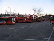
Numerous London buses run through and within the borough.
Travel to work
In March 2011, the main forms of transport that residents used to travel to work were: driving a car or van, 23.5% all residents aged 16–74; underground, metro, light rail, tram, 18.4%; train, 6.2%; bus, minibus or coach, 4.6%; on foot, 3.7%; work mainly at or from home, 2.6%; passenger in a car or van, 1.5%.[16]
History
The borough was formed in 1965 by the London Government Act 1963 as a merger of the former area of:
| Former local government district | Population (1961)[17] |
|---|---|
| Municipal Borough of Ilford | 178,024 |
| Municipal Borough of Wanstead and Woodford | 61,416 |
| northern part of the Municipal Borough of Dagenham around Hog Hill | 3,569 |
| south eastern part of Chigwell Urban District around Hainault | 7,071 |
All of which had been transferred from Essex to Greater London by the Act.
Destruction of Hainault Forest
An act of parliament in 1851 permitted the virtual destruction of Hainault Forest and 92% of the forest was cut down using machines specially designed for the task. The loss of this habitat outraged public opinion far beyond the local area. The naturalist Oliver Rackham argued that this led to the creation of the modern British conservation movement with the creation of organisations which successfully opposed such a fate happening to Epping Forest, which only lost around 10% of its area.
Redbridge London Borough Council
Summary of Council results:
| Overall control | Conservative | Labour | Lib Dem | Others | |
| 2014 | Labour | 25 | 35 | 3 | 0 |
| 2012 | No Overall Control | 29 | 25 | 7 | 2 |
| 2010[18][19] | No Overall Control | 30 | 26 | 7 | 0 |
| 2009 | No Overall Control | 31 | 14 | 13 | 5 |
| 2006[20] | Conservative | 33 | 18 | 10 | 2 |
| 2002 | Conservative | 33 | 21 | 9 | - |
| 1998 | No overall control | 23 | 30 | 9 | 0 |
| 1994 | No overall control | 24 | 29 | 9 | |
| 1990[21] | Conservative | 42 | 18 | 3 | |
| 1986 | Conservative | 45 | 17 | 1 | |
| 1982 | Conservative | 51 | 12 | ||
| 1978 | Conservative | 50 | 13 | ||
| 1974 | Conservative | 45 | 15 | ||
| 1971 | Conservative | 42 | 18 | ||
| 1968 | Conservative | 55 | 5 | ||
| 1964 | Conservative | 45 | 15 |
Education
Redbridge Council is the Local Education Authority. The Borough has the accolade of sending more young people to university than any other borough in the country in both 2011 and 2012. GCSE and A Level results are consistently higher than the Country's average. A 2017 report by Trust for London and the New Policy Institute found that Redbridge has the highest proportion of 19 year olds with Level 3 qualifications (equivalent to an A Level) of any London borough.[22]
All schools in the borough take part in the Redbridge Schools Choral Festival, a biennial music festival held in the Royal Albert Hall in Knightsbridge.[23] It was inaugurated in 1976. Around 1,900 children from Redbridge schools take part in each festival, with the latest edition being held in 2018.
References
- ↑ 2011 Census: Ethnic group, local authorities in England and Wales, Office for National Statistics (2012). See Classification of ethnicity in the United Kingdom for the full descriptions used in the 2011 Census.
- ↑ "London Places" (PDF). Greater London Authority. GLA. Archived from the original (PDF) on 6 September 2015. Retrieved 11 October 2015.
- ↑ Mills, A., Dictionary of London Place Names, (2001)
- ↑ "Valentine's Park". Cricinfo. ESPN. Retrieved 22 September 2015.
- 1 2 3 "Population change 2001-2011". Office for National Statistics. Office for National Statistics. 2012. Retrieved 30 November 2014.
- ↑ "Population statistics". Redbridge i. Redbridge Council. Retrieved 30 November 2014.
- ↑ "2011 Census - Population". Redbridge i. Redbridge Council. Retrieved 30 November 2014.
- ↑ "How long can you expect to live in 'Good' general health?". Office for National Statistics. Office for National Statistics. 2014. Retrieved 30 November 2014.
- 1 2 3 4 "2011 Census - Diversity". Redbridge i. Redbridge Council. Retrieved 30 November 2014.
- ↑ "Redbridge: Total Population". A Vision of Britain Through Time. Great Britain Historical GIS Project. Retrieved 6 September 2011.
- ↑ "KS006 - Ethnic group". NOMIS. Retrieved 30 January 2016.
- ↑ "Ethnic Group by measures". NOMIS. Retrieved 8 January 2016.
- ↑ Saha, Anamik; Watson, Sophie (2013). Suburban drifts: mundane multiculturalism in outer London. Resourceful Cities, Research Committee 21, 29–31 August 2013, Humboldt-University Berlin, Institute for Social Science, Dept for Urban and Regional Sociology.
- ↑ Sustrans, http://www.sustrans.org.uk/ncn/map/route/roding-valley-way
- 1 2 3 4 5 6 Rose, Douglas (1999). The London Underground, A Diagrammatic History. London: Douglas Rose/Capital Transport. ISBN 1-85414-219-4. OCLC 59556887.
- ↑ "2011 Census: QS701EW Method of travel to work, local authorities in England and Wales". Office for National Statistics. Retrieved 23 November 2013. Percentages are of all residents aged 16-74 including those not in employment. Respondents could only pick one mode, specified as the journey’s longest part by distance.
- ↑ Great Britain Historical GIS / University of Portsmouth, Redbridge. Retrieved 10 February 2008.
- ↑ "REDBRIDGE: Council election count - LIVE". East London and West Essex Guardian Series.
- ↑ http://www.redbridge.gov.uk/cms/the_council/council_people_and_elections/elections/election_results/2010_local_election_results.aspx
- ↑ "2006 Local election results". redbridge.gov.uk.
- ↑ GLA. "Archived copy" (PDF). Archived from the original (PDF) on 28 July 2011. Retrieved 31 January 2016. , London Borough Council Elections May 2010, March 2011, accessed 21 April 2011.
- ↑ "London's Poverty Profile". Trust for London. Retrieved 19 June 2018.
- ↑ Redbridge Music Service - Redbridge Schools' Choral Festival
http://www2.redbridge.gov.uk/cms/leisure_and_libraries/leisure_and_culture/enjoy_redbridge.aspx
External links
| Wikimedia Commons has media related to London Borough of Redbridge. |
Gallery
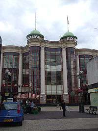 Exchange shopping centre, Ilford
 Fullwell Cross library, Barkingside
 Gants Hill roundabout and station, Gants Hill
 Newbury Park station, Newbury Park
| Districts | 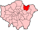 | |
|---|---|---|
| Attractions |
| |
| Constituencies | ||
| Parks and open spaces |
| |
| Tube and rail stations | ||
| History | ||
| Other topics | ||