Seaford, Delaware
| Seaford, Delaware | |
|---|---|
| City | |
.jpg) High Street in Seaford | |
| Etymology: Seaford, East Sussex in England | |
| Nickname(s): Youth Sports Capital (official), Nylon Capital of the World (historical) | |
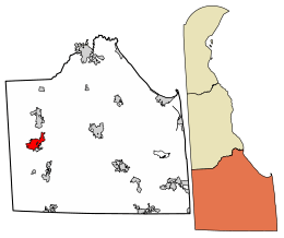 Location of Seaford in Sussex County, Delaware. | |
 Seaford Location within the state of Delaware  Seaford Seaford (the US) | |
| Coordinates: 38°38′28″N 75°36′40″W / 38.64111°N 75.61111°WCoordinates: 38°38′28″N 75°36′40″W / 38.64111°N 75.61111°W | |
| Country |
|
| State |
|
| County |
|
| Incorporated | April 6, 1865 |
| Government | |
| • Type | Mayor-council |
| • Mayor | David Genshaw |
| • Vice Mayor | Dan H. Henderson |
| Area[1] | |
| • Total | 5.30 sq mi (13.73 km2) |
| • Land | 5.23 sq mi (13.56 km2) |
| • Water | 0.07 sq mi (0.18 km2) |
| Elevation | 23 ft (7 m) |
| Population (2010) | |
| • Total | 6,928 |
| • Estimate (2016)[2] | 7,736 |
| • Density | 1,478.03/sq mi (570.68/km2) |
| Time zone | UTC−5 (Eastern (EST)) |
| • Summer (DST) | UTC−4 (EDT) |
| ZIP code | 19973 |
| Area code(s) | 302 |
| FIPS code | 10-64320 |
| GNIS feature ID | 214626[3] |
| Website | www.seafordde.com |
Seaford is a city located along the Nanticoke River in Sussex County, Delaware. According to the 2010 Census Bureau figures, the population of the city is 6,928, an increase of 3.4% from the 2000 census.[4] It is part of the Salisbury, Maryland-Delaware Metropolitan Statistical Area.
It is the largest city fully within Sussex County and was voted the 28th Best Small Town in America.[5] It hosted the Seaford Eagles of the Eastern Shore Baseball League.
History
Name origin
Seaford is named after Seaford, East Sussex in England.[6]
Once in Maryland
All land in current western and southern Sussex County was first settled as part of Maryland. Seaford, along with Bridgeville, Greenwood, Middleford, and others, were all part of Dorchester County in the Province of Maryland. Blades, Laurel, and Concord areas, on the other hand, were part of Somerset County. It is reported that an error in a map coordinate resulted in the east-west line of Delaware being from current Delmar to Fenwick. The original agreement had the eastwest line at the Cape Henlopen, not at the false cape. If the line had survived, Seaford would now be in Maryland. After many years in the courts of London, the boundary lines are as the surveyors Mason and Dixon defined in 1763.
Governor Ross and the Civil War
Only 20 acres (81,000 m2) of land remain from the plantations original size of 1,400 acres (5.7 km2). There are many notable buildings on this property, you can find a granary, stable, smokehouse, corn cribs, and Delaware's only documented surviving slave quarters.
Downtown renovations
Seaford is one of seven Main Street communities that participated in the Delaware Main Street Program, part of the national Main Street plan to revitalize commercial districts. The program was developed in the 1970s by the National Trust Main Street Center,[7] which was in turn a program of the National Trust for Historic Preservation. In 1999–2000 Seaford's historic downtown area along High Street underwent major renovations, preserving the city's old fashioned charm with $1.5 million of landscaping, street paving, sidewalks, lamp posts, street lights, and utility upgrades.
National Register of Historic Places listings
The Building at 200-202A High Street, Building at 218 High Street, Building at High and Cannon Streets, Burton Hardware Store, J. W. Cox Dry Goods Store, First National Bank of Seaford, Hearn and Rawlins Mill, Lawrence, Maston House, Jesse Robinson House, Edgar and Rachel Ross House, Gov. William H. Ross House, St. Luke's Protestant Episcopal Church, Seaford Station Complex, and Sussex National Bank of Seaford are listed on the National Register of Historic Places.[8]
Geography
Seaford is located at 38°38′28″N 75°36′40″W / 38.64111°N 75.61111°W (38.6412256, -75.6110381).[9]
According to the United States Census Bureau, the city has a total area of 3.5 square miles (9.1 km2), of which, 3.5 square miles (9.1 km2) of it is land and 0.04 square miles (0.10 km2) of it (1.14%) is water.
Climatology
Situated on the Atlantic Coastal Plain, Seaford's weather is moderated by the Atlantic Ocean. Seaford has a mild subtropical climate consisting of hot, humid summers and mild winters. The average daytime high in July is 87 °F (30.6 °C) and a low of 65 °F (18.3 °C); in January, the average high is 44 °F (6.7 °C) with an average low of 25 °F (-3.9 °C) [10] The month of highest average rainfall is August with 5.59 inches (142.0 mm) of rain, while February is historically the driest month, receiving an average of only 3.17 inches (80.5 mm) of rain.[10]
The highest official temperature ever recorded in Seaford was 104 °F (40.0 °C) on July 22, 2011,[11] while the all-time low was -13 °F (-25.0 °C) on January 28, 1987.[12]
Demographics
| Historical population | |||
|---|---|---|---|
| Census | Pop. | %± | |
| 1860 | 624 | — | |
| 1870 | 1,304 | 109.0% | |
| 1880 | 1,542 | 18.3% | |
| 1890 | 1,462 | −5.2% | |
| 1900 | 1,724 | 17.9% | |
| 1910 | 2,108 | 22.3% | |
| 1920 | 2,141 | 1.6% | |
| 1930 | 2,468 | 15.3% | |
| 1940 | 2,804 | 13.6% | |
| 1950 | 3,087 | 10.1% | |
| 1960 | 4,430 | 43.5% | |
| 1970 | 5,537 | 25.0% | |
| 1980 | 5,256 | −5.1% | |
| 1990 | 5,689 | 8.2% | |
| 2000 | 6,699 | 17.8% | |
| 2010 | 6,928 | 3.4% | |
| Est. 2016 | 7,736 | [2] | 11.7% |
| U.S. Decennial Census[13] | |||
As of the census[14] of 2000, there were 6,699 people, 2,629 households, and 1,664 families residing in the city. The population density was 1,925.9 people per square mile (743.2/km²). There were 2,809 housing units at an average density of 807.5 per square mile (311.7/km²). The racial makeup of the city was 64.04% White, 30.02% African American, 0.37% Native American, 1.49% Asian, 0.19% Pacific Islander, 1.72% from other races, and 2.16% from two or more races. Hispanic or Latino of any race were 4.25% of the population.
There were 2,629 households out of which 31.5% had children under the age of 18 living with them, 37.8% were married couples living together, 22.3% had a female householder with no husband present, and 36.7% were non-families. 32.1% of all households were made up of individuals and 15.4% had someone living alone who was 65 years of age or older. The average household size was 2.36 and the average family size was 2.95.
In the city, the age distribution of the population shows 25.6% under the age of 18, 9.4% from 18 to 24, 24.1% from 25 to 44, 18.9% from 45 to 64, and 22.0% who were 65 years of age or older. The median age was 38 years. For every 100 females, there were 77.6 males. For every 100 females age 18 and over, there were 69.8 males.
The median income for a household in the city was $28,402, and the median income for a family was $39,688. Males had a median income of $30,467 versus $23,490 for females. The per capita income for the city was $15,022. About 22.0% of families and 27.6% of the population were below the poverty line, including 43.4% of those under age 18 and 13.2% of those age 65 or over.
Government
Seaford has a mayor-council system of government with a Mayor and a City Council. As of 2017, the Mayor of Seaford is David Genshaw while the members of City Council are Vice Mayor Dan H. Henderson, Grace S. Peterson, Leanne Phillips-Lowe, Orlando Holland, and H. William Mulvaney III.[15]
Infrastructure
Transportation
U.S. Route 13 is the main north-south thoroughfare within city limits, with Delaware Route 20 being the main east-west highway. U.S. Route 13 connects Seaford with Bridgeville to the north and Laurel to the south as part of the Sussex Highway. State Route 20 connects Seaford with Millsboro to the east and tiny Reliance, Maryland to the west.
The closest airport with commercial air service to Seaford is the Wicomico Regional Airport in Salisbury, Maryland. The closest public airport is Laurel Airport in Laurel, Delaware. There is also an airport in Georgetown called the Delaware Coastal Airport. This airport has a jet service section, as part of the nearby industrial park.
DART First State operates the Route 212 bus that connects Seaford to Georgetown and Delmar and the Route 903F bus that runs on a loop through Seaford.[16]
Freight rail service in Seaford is provided by two carriers: the Delmarva Central Railroad and the Maryland and Delaware Railroad. The Delmarva Central Railroad runs north-south through the city, parallel to US 13. It interchanges with the Maryland and Delaware Railroad in Seaford, which heads west to Federalsburg and Cambridge in Maryland.
Utilities
The City of Seaford Electric Department provides electricity to about 6,700 customers in the city. The electric department owns 3 substations and more than 37 miles (60 km) of transmission and distribution lines. The city purchases its electricity and is a member of the Delaware Municipal Electric Corporation.[17] The Public Works department provides water and sewer service to the city.[18] Natural gas service in Seaford is provided by Chesapeake Utilities.[19]
Health care
Nanticoke Memorial Hospital and the Nanticoke Cancer Care Center, both operated by Nanticoke Health Services, are located in Seaford.[20]
Education
Students in Seaford are offered a number of public and private school choices.
Public
Seaford is home to the Seaford School District and services children in the Seaford, Blades, Concord, Middleford, and Woodland. The District contains four elementary schools, one middle school and Seaford Senior High School.
Private
The most notable private school is Seaford Christian Academy, which closed in 2017 to be purchased by Cross Christian School.
Media
Radio
The only radio station calling Seaford its home is WGBG 92.7 FM, which broadcasts from just outside the city limits. It plays conservative talk radio personalities such as Rush Limbaugh, Mark Levin, and Michael Savage. Legendary disc jockey Bill Crisp at one time owned the only AM/FM radio stations licensed to Seaford,WSFD/WSUX. Their studios were located on S. Dual Highway just two miles south of Seaford. WSFD broadcast on a frequency of 1280 AM as a daytime only radio station with 1000 watts of power serving Lower Delaware. Some of its formats included Adult Contemporary and Country. The station went dark in the late 1990s. WSUX broadcast 3000 watts on a frequency of 98.3 FM and was known as Stereo 98. The station survived years of popularity in the 70s and 80s with a Top 40 format serving Maryland's Eastern Shore and Lower Delaware. The station was later sold and has since switched frequency to 98.5.
Television
WDPB-TV 64 is the only television station originating from Seaford. It is a subsidiary of WHYY-TV in Philadelphia and an affiliate of PBS.
Newspapers
Seaford is home to one weekly newspaper, the Seaford Star. The Seaford Star is a publication of Morning Star Publications, Inc., which is owned by Seaford residents Bryant and Carol Richardson. The newspaper retails for 50 cents per issue and is also available by subscription.
Points of interest
Seaford boasts tourism opportunities for all ages and interests.
Within the city
- Seaford Christmas Parade – The biggest Christmas Parade on the Delmarva Peninsula. It is a night time parade, on the first Saturday of December. https://web.archive.org/web/20121215001756/http://www.mychristmasparade.com/has more information, including the entry form for participants.
- Kiwanis Park – a beautiful Memorial Park located on Stein Highway.
- Gateway Park – a park complete with brick sidewalks and a fountain, forming the gateway into beautiful downtown Seaford.
- Soroptimist Park – a park located on Williams Pond complete with a playground and a pavilion for parties.
- Nutter Park – named in honor of past Councilman Henry E. Nutter, Jr.; located in east Seaford with playground equipment and basketball courts.
- Williams Pond Park – a ballpark run by the Nanticoke Little League.
- Sports Complex – the newest park; includes the newly constructed Jay's Nest, the community-built playground. One softball field has been completed to date but three more softball fields, a youth football field, youth hockey field and volleyball court are planned.
- The Jays Nest – Seaford's community built playground.
- Hooper's Landing Golf & Country Club – home to a public access 18-hole course, pool, tennis courts and recently renovated driving range. – http://www.seafordde.com/index.cfm?ref=84100
- Nanticoke River – in downtown Seaford, the river is paralleled by the recently constructed Nanticoke River Walk.
- Seaford Museum – the Seaford Museum is located at 203 High Street in the historic former post office and serves as a repository for items of significance in the history of Seaford; collections and exhibits highlight Seaford area history from Native Americans to present day; the original map of Seaford is on display; the museum is handicapped accessible. Seaford Museum Web Site: http://www.seafordhistoricalsociety.com/index.cfm?ref=89265
- Ross Mansion and Plantation – located at 1101 North Pine Street Extended in Seaford; former residence of former Delaware Governor William H. H. Ross; it is a 20-acre (81,000 m2) property that includes in addition to the Mansion, a granary with farm equipment exhibits, carriage house, a Victorian cottage and Delaware's only documented log slave quarters; the Mansion is a brick Italian Villa style structure completed in 1859; it is furnished in authentic Victorian style with many pieces having belonged to the Ross family. Ross Mansion Web Site: https://web.archive.org/web/20141006082633/http://www.seafordhistoricalsociety.com/index.cfm?ref=42198
- Nanticoke Riverfest takes place the second weekend in July and the Nanticoke River is open for citizens to float down the river on inner tubes. There is also a three-day festival. The Carnival opens Thursday. Friday evening and all day Saturday merchants and vendors sell their products on High Street. Performers and comedians shows. Free concerts with live bands perform Friday night and Saturday night. There is also a Miss Riverfest Pageant for teenagers to enter, and a Little Miss Riverfest pageant for younger children to enter.
- The AFRAM Festival is a celebration of African American culture which is held the second weekend of August in Nutter Park.
Near the city
- Woodland Ferry – located west of Seaford, the ferry operates sunup to sundown, seven days a week with no fare charged; the 200-year-old cable-run ferry boat crossing the Nanticoke River, one of the last remaining ferries on the East Coast, was established circa 1793 by the Cannon family, and served as a major river crossing and trading center for travelers.
- U.N.O.I. Mill – over 100 years old, still has the original corn stone in use to create products sold commercially today.
- Patty Cannon House – located outside of Seaford in Reliance, Delaware (formerly Johnson's Cross Roads), this house is where the noted kidnapping group including Patty Cannon had its headquarters; the group was involved in robbery and entrapment of free blacks in the area; this house was ideal because of its location: one side sits in Maryland while the other side sits in Delaware; today, the house still stands and is a historical landmark.
Notable people
- U.S. Ambassador Horace G. Knowles
- Former baseball player Delino DeShields
- Former American football player Lovett Purnell
- Former Olympic baseball player Mike Neill
- Aerospace Tycoon Lee F. Booth
- Delaware state senator Stephanie Hansen
Notes and references
- ↑ "2016 U.S. Gazetteer Files". United States Census Bureau. Retrieved Jul 25, 2017.
- 1 2 "Population and Housing Unit Estimates". Retrieved June 9, 2017.
- ↑ "Seaford". Geographic Names Information System. United States Geological Survey.
- ↑ "Archived copy". Archived from the original on 2016-12-31. Retrieved 2013-04-29.
- ↑ Crampton, N. (1996). The 100 Best Small Towns in America. New York: Prentice Hall.
- ↑ Katy Rice, 'Across the Pond', in Sussex Society, September 2011, p. 28
- ↑ National Trust Main Street Center
- ↑ National Park Service (2010-07-09). "National Register Information System". National Register of Historic Places. National Park Service.
- ↑ "US Gazetteer files: 2010, 2000, and 1990". United States Census Bureau. 2011-02-12. Retrieved 2011-04-23.
- 1 2 Average Weather for Seaford, DE - Temperature and Precipitation
- ↑ Daily Averages for Seaford, DE (19973) - weather.com
- ↑ Daily Averages for Seaford, DE (19973) - weather.com
- ↑ "Census of Population and Housing". Census.gov. Retrieved June 4, 2015.
- ↑ "American FactFinder". United States Census Bureau. Retrieved 2008-01-31.
- ↑ "City Council". City of Seaford. Retrieved June 29, 2017.
- ↑ "Routes and Schedules". DART First State. Retrieved 2013-08-16.
- ↑ "Electric". City of Seaford. Retrieved June 29, 2017.
- ↑ "Public Works". City of Seaford. Retrieved June 29, 2017.
- ↑ "Delmarva Service Territory". Chesapeake Utilities. Retrieved August 14, 2017.
- ↑ "Locations & Directions". Nanticoke Health Services. Retrieved August 10, 2017.
External links
Dover (capital) | ||
| Topics |
|  |
| Society |
| |
| Cities | ||
| Towns |
| |
| Counties | ||