Frankford, Delaware
| Frankford, Delaware | |
|---|---|
| Town | |
 | |
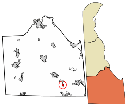 Location of Frankford in Sussex County, Delaware. | |
 Frankford Location within the state of Delaware  Frankford Frankford (the US) | |
| Coordinates: 38°31′02″N 75°14′06″W / 38.51722°N 75.23500°WCoordinates: 38°31′02″N 75°14′06″W / 38.51722°N 75.23500°W | |
| Country |
|
| State |
|
| County |
|
| Area[1] | |
| • Total | 0.73 sq mi (1.89 km2) |
| • Land | 0.73 sq mi (1.89 km2) |
| • Water | 0.00 sq mi (0.00 km2) |
| Elevation | 33 ft (10 m) |
| Population (2010) | |
| • Total | 847 |
| • Estimate (2016)[2] | 951 |
| • Density | 1,304.53/sq mi (503.52/km2) |
| Time zone | UTC−5 (Eastern (EST)) |
| • Summer (DST) | UTC−4 (EDT) |
| ZIP code | 19945 |
| Area code(s) | 302 |
| FIPS code | 10-28310 |
| GNIS feature ID | 213980[3] |
Frankford is a town in Sussex County, Delaware, United States. The population was 847 at the 2010 census, an increase of 18.6% over the previous decade.[4] It is part of the Salisbury, Maryland-Delaware Metropolitan Statistical Area.
History
Located on U.S. Route 113, Frankford, was founded in 1808 and incorporated in 1937. The town was named Frankford Village in 1848 upon the acquisition of a post office. The establishment of the Pennsylvania Railroad brought a hotel, commercial establishments and an opera house to make Frankford a thriving commercial and cultural center. Today, the town is a mere shadow of that golden era with just a handful of thriving businesses.
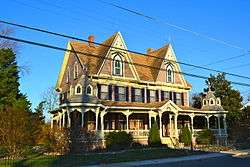
The Capt. Ebe Chandler House (1880) was added to the National Register of Historic Places in 1979.[5]
Demographics
| Historical population | |||
|---|---|---|---|
| Census | Pop. | %± | |
| 1880 | 380 | — | |
| 1890 | 519 | 36.6% | |
| 1900 | 424 | −18.3% | |
| 1910 | 395 | −6.8% | |
| 1920 | 443 | 12.2% | |
| 1930 | 450 | 1.6% | |
| 1940 | 563 | 25.1% | |
| 1950 | 615 | 9.2% | |
| 1960 | 558 | −9.3% | |
| 1970 | 635 | 13.8% | |
| 1980 | 828 | 30.4% | |
| 1990 | 591 | −28.6% | |
| 2000 | 714 | 20.8% | |
| 2010 | 847 | 18.6% | |
| Est. 2016 | 951 | [2] | 12.3% |
| U.S. Decennial Census[6] | |||
As of the census[7] of 2000, there were 714 people, 227 households, and 172 families residing in the town. The population density was 1,012.7 people per square mile (388.3/km²). There were 258 housing units at an average density of 365.9 per square mile (140.3/km²). The racial makeup of the town was 45.24% White, 35.01% African American, 2.94% Native American, 0.42% Asian, 10.92% from other races, and 5.46% from two or more races. Hispanic or Latino of any race were 20.73% of the population.
There were 227 households out of which 37.4% had children under the age of 18 living with them, 52.0% were married couples living together, 16.7% had a female householder with no husband present, and 24.2% were non-families. 18.9% of all households were made up of individuals and 11.0% had someone living alone who was 65 years of age or older. The average household size was 3.15 and the average family size was 3.62.
In the town, the population was spread out with 32.5% under the age of 18, 9.5% from 18 to 24, 25.4% from 25 to 44, 19.3% from 45 to 64, and 13.3% who were 65 years of age or older. The median age was 31 years. For every 100 females, there were 88.9 males. For every 100 females age 18 and over, there were 88.3 males.
The median income for a household in the town was $35,333, and the median income for a family was $35,729. Males had a median income of $24,375 versus $20,875 for females. The per capita income for the town was $13,711. About 9.5% of families and 14.5% of the population were below the poverty line, including 21.5% of those under age 18 and 16.4% of those age 65 or over.
References
- ↑ "2016 U.S. Gazetteer Files". United States Census Bureau. Retrieved Jul 25, 2017.
- 1 2 "Population and Housing Unit Estimates". Retrieved June 9, 2017.
- ↑ "Frankford". Geographic Names Information System. United States Geological Survey.
- ↑ "Archived copy". Archived from the original on 2016-12-31. Retrieved 2013-04-29.
- ↑ National Park Service (2010-07-09). "National Register Information System". National Register of Historic Places. National Park Service.
- ↑ "Census of Population and Housing". Census.gov. Archived from the original on May 12, 2015. Retrieved June 4, 2015.
- ↑ "American FactFinder". United States Census Bureau. Archived from the original on 2013-09-11. Retrieved 2008-01-31.