Laurel, Delaware
| Laurel, Delaware | |
|---|---|
| Town | |
 | |
| Etymology: Laurel bushes that grew alongside Broad Creek | |
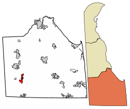 Location of Laurel in Sussex County, Delaware. | |
 Laurel Location within the state of Delaware  Laurel Laurel (the US) | |
| Coordinates: 38°33′23″N 75°34′17″W / 38.55639°N 75.57139°WCoordinates: 38°33′23″N 75°34′17″W / 38.55639°N 75.57139°W | |
| Country |
|
| State |
|
| County |
|
| Area[1] | |
| • Total | 2.98 sq mi (7.72 km2) |
| • Land | 2.89 sq mi (7.48 km2) |
| • Water | 0.09 sq mi (0.24 km2) |
| Elevation | 26 ft (8 m) |
| Population (2010) | |
| • Total | 3,708 |
| • Estimate (2016)[2] | 4,160 |
| • Density | 1,441.44/sq mi (556.45/km2) |
| Time zone | UTC−5 (Eastern (EST)) |
| • Summer (DST) | UTC−4 (EDT) |
| ZIP code | 19956 |
| Area code | 302 |
| FIPS code | 10-41310 |
| GNIS feature ID | 214203[3] |
Laurel is a town in Sussex County, Delaware, United States. The population was 3,708 at the 2010 census.[4] Laurel is part of the Salisbury, Maryland-Delaware Metropolitan Statistical Area. It once hosted the Laurel Blue Hens of the Eastern Shore Baseball League.
History
.png)
The site of the town of Laurel was a Nanticoke Indian settlement known as Broad Creek Town during most of the eighteenth century. Its Nanticoke name is unknown. The Indian settlement was created on tracts known as Bachelor's Delight and Greenland in 1711 when the government of Maryland, who originally claimed this part of Delaware, set aside land for the Nanticoke Indians. Nearly all the Indian settlers left within 50 years, relocating to western Pennsylvania. The present town was laid out along the Broad Creek in the 1790s and was named for the laurel bushes that grew alongside the creek.[5]
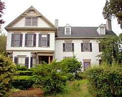
The Chipman Potato House, Chipman's Mill, Collins Potato House, Hearn Potato House, E. L. Hitch Potato House, Laurel Historic District, Moore Potato House, Old Christ Church, Phillips Potato House, Ralph Potato House, Rider Potato House, Ross Point School, Spring Garden, Stanley Potato House, and Wright Potato House are listed on the National Register of Historic Places.[6]
On March 29, 1929 the town was merged with the neighboring town of North Laurel which comprised most of the current town north of Broad Creek (then known as Laurel River).[7] This merger was not properly reported to the United States Census Bureau, which resulted in the North Laurel's population not being included with the population of Laurel in the 1930 United States Census. As such, the US Census Bureau did not immediately make a change to the 1930 population statistics once the error was discovered, however it acknowledged in 1940 that the correct population for Laurel in 1930 was 2,542.[8]
Geography
Laurel is located on the Atlantic Coastal Plain in southwestern Delaware at 38°33′23″N 75°34′17″W / 38.55639°N 75.57139°W (38.5565041, −75.5713141).[9]
According to the United States Census Bureau, the town has a total area of 1.7 square miles (4.4 km2), of which 1.7 square miles (4.4 km2) is land and 0.1 square miles (0.26 km2) (4.07%) is water.
Demographics
| Historical population | |||
|---|---|---|---|
| Census | Pop. | %± | |
| 1860 | 970 | — | |
| 1870 | 1,080 | 11.3% | |
| 1880 | 1,022 | −5.4% | |
| 1890 | 2,388 | 133.7% | |
| 1900 | 1,825 | −23.6% | |
| 1910 | 2,166 | 18.7% | |
| 1920 | 2,253 | 4.0% | |
| 1930 | 2,542 | 12.8% | |
| 1940 | 2,884 | 13.5% | |
| 1950 | 2,700 | −6.4% | |
| 1960 | 2,709 | 0.3% | |
| 1970 | 2,408 | −11.1% | |
| 1980 | 3,052 | 26.7% | |
| 1990 | 3,226 | 5.7% | |
| 2000 | 3,668 | 13.7% | |
| 2010 | 3,708 | 1.1% | |
| Est. 2016 | 4,160 | [2] | 12.2% |
| U.S. Decennial Census[10] | |||
957 families, 1,389 households, 3,668 people reside in the town. The population density was 2,215.9 people per square mile (853.1/km²). There were 1,561 housing units at an average density of 943.0 per square mile (363.1/km²). The racial makeup of the town was 55.56% White, 39.42% African American, 0.35% Native American, 0.95% Asian, 0.03% Pacific Islander, 1.20% from other races, and 2.48% from two or more races. Hispanic or Latino of any race were 2.32% of the population.[11]
There were 1,389 households out of which 37.9% had children under the age of 18 living with them, 39.4% were married couples living together, 26.1% had a female householder with no husband present, and 31.1% were non-families. 26.4% of all households were made up of individuals and 12.0% had someone living alone who was 65 years of age or older. The average household size was 2.64 and the average family size was 3.19.
In the town, the age distribution of the population shows 33.2% under the age of 18, 10.6% from 18 to 24, 26.5% from 25 to 44, 16.7% from 45 to 64, and 12.9% who were 65 years of age or older. The median age was 30 years. For every 100 females, there were 83.1 males. For every 100 females age 18 and over, there were 72.9 males.
The median income for a household in the town was $28,321, and the median income for a family was $30,329. Males had a median income of $28,006 versus $18,550 for females. The per capita income for the town was $13,594. About 18.7% of families and 21.2% of the population were below the poverty line, including 33.6% of those under age 18 and 11.4% of those age 65 or over.
Sports
On August 13, 2011 the District 3 All-Stars from Laurel won the Senior League Softball World Series for Little League, going undefeated in the tournament and defeating Puerto Rico in the championship game by a score of 2–0.[12]
The Laurel High School Bulldogs have won three Division 2 State Football Championships in 1986, 1987, and 1991.
Notable residents
.jpg)
- Mark Briscoe – Professional wrestler[13]
- Jay Briscoe – Professional wrestler[14]
- Bert Carvel – former Governor of Delaware
- William B. Cooper – former Governor of Delaware[15]
- Carlton Elliott – former NFL player[16]
- Alex Ellis – current NFL player[17]
- Dallas Marvil – Consensus All-American football player, 1931[18]
- Joshua H. Marvil – former Governor of Delaware[19]
- Nathaniel Mitchell – former Governor of Delaware, Member of the Continental Congress
- Ron Waller – former NFL player and coach
Media
- Laurel Star (weekly local newspaper published by Morning Star Publications)
- Leader & State Register (weekly local newspaper published by Independent Newspapers Inc.)
- The News Journal (statewide daily newspaper published by Gannett Co.)
- Delaware State News (southern Delaware daily newspaper published by Independent Newspapers Inc.)
- WBOC-TV (Channel 16, CBS Affiliate) has its broadcast tower located in Laurel.
- FOX 21 (Channel 21, FOX Affiliate) has its broadcast tower located in Laurel.
- WMDT (Channel 47, ABC Affiliate)
- WKDB (95.3FM known as "Studio 95.3")
References
- ↑ "2016 U.S. Gazetteer Files". United States Census Bureau. Retrieved July 25, 2017.
- 1 2 "Population and Housing Unit Estimates". Retrieved June 9, 2017.
- ↑ "Laurel". Geographic Names Information System. United States Geological Survey.
- ↑ "Archived copy". Archived from the original on December 31, 2016. Retrieved April 29, 2013.
- ↑ Federal Writers' Project (1938). The ocean highway: New Brunswick, New Jersey to Jacksonville, Florida. American Guide Series. New York City: Modern Age Books. Retrieved 2009-04-10.
- ↑ National Park Service (2010-07-09). "National Register Information System". National Register of Historic Places. National Park Service.
- ↑ "North Laurel Votes In Favor Of Combine". The News Journal(Wilmington, Delaware). March 30, 1929.
- ↑ https://www2.census.gov/library/publications/decennial/1940/population-volume-1/33973538v1ch03.pdf
- ↑ "US Gazetteer files: 2010, 2000, and 1990". United States Census Bureau. February 12, 2011. Retrieved 2011-04-23.
- ↑ "Census of Population and Housing". Census.gov. Retrieved June 4, 2015.
- ↑ "American FactFinder". United States Census Bureau. Retrieved 2008-01-31.
- ↑ http://www.delawareonline.com/article/20110814/SPORTS11/108140368/Laurel-softball-top-world?odyssey=tab%7Ctopnews%7Ctext%7CHome
- ↑ Buckler, David. "Mark Briscoe". Black Pants, Inc.
- ↑ Buckler, David. "Jay Briscoe". Black Pants, Inc.
- ↑
- ↑ https://www.pro-football-reference.com/players/E/ElliCa20.htm
- ↑ "Alex Ellis, TE for the New Orleans Saints". www.nfl.com.
- ↑ Charles Bartlett (October 7, 1931). "This Dal Marvil of N. U. May Be Fat, but Look Out". Chicago Daily Tribune. p. 28.
- ↑ "Joshua Hopkins Marvil". www.nga.org.
External links
| Wikivoyage has a travel guide for Laurel (Delaware). |
- Official Website of the Town of Laurel
- Laurel Chamber of Commerce
- Laurel (Delaware) Historical Society
| Counties |  | |
|---|---|---|
| Principal city | ||
| Places 5k–20k | ||
| Places 1k–5k | ||