Harrington, Delaware
| Harrington, Delaware | |
|---|---|
| City | |
| Etymology: Hon. Samuel M. Harrington | |
| Motto(s): The Hub of Delaware | |
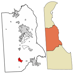 Location of Harrington in Kent County, Delaware. | |
 Harrington Location within the state of Delaware  Harrington Harrington (the US) | |
| Coordinates: 38°55′25″N 75°34′40″W / 38.92361°N 75.57778°WCoordinates: 38°55′25″N 75°34′40″W / 38.92361°N 75.57778°W | |
| Country |
|
| State |
|
| County |
|
| Government | |
| • Type | Mayor-council |
| • Mayor | Anthony Moyer |
| Area[1] | |
| • Total | 2.75 sq mi (7.13 km2) |
| • Land | 2.75 sq mi (7.12 km2) |
| • Water | 0.01 sq mi (0.02 km2) |
| Elevation | 59 ft (18 m) |
| Population (2010) | |
| • Total | 3,562 |
| • Estimate (2016)[2] | 3,679 |
| • Density | 1,339.28/sq mi (517.04/km2) |
| Time zone | UTC−5 (Eastern (EST)) |
| • Summer (DST) | UTC−4 (EDT) |
| ZIP code | 19952 |
| Area code(s) | 302 Exchange: 398 |
| FIPS code | 10-33120 |
| GNIS feature ID | 214060[3] |
Harrington is a city in Kent County, Delaware, United States. It is part of the Dover, Delaware Metropolitan Statistical Area. Harrington hosts the annual Delaware State Fair each July. The population was 3,562 at the 2010 census.[4]
History
Harrington was named for Hon. Samuel M. Harrington, a former chancellor of the state.[5] The town developed at a railroad junction along the Delaware Railroad and served as a rural trading center.[6]
Geography
Harrington is located at 38°55′25″N 75°34′40″W / 38.92361°N 75.57778°W (38.9237244, -75.5777033).[7]
According to the United States Census Bureau, the city has a total area of 2.0 square miles (5.2 km2), of which, 2.0 square miles (5.2 km2) of it is land and 0.04 square miles (0.10 km2) of it (1.48%) is water.
Demographics
| Historical population | |||
|---|---|---|---|
| Census | Pop. | %± | |
| 1880 | 745 | — | |
| 1900 | 1,242 | — | |
| 1910 | 1,500 | 20.8% | |
| 1920 | 1,617 | 7.8% | |
| 1930 | 1,812 | 12.1% | |
| 1940 | 2,113 | 16.6% | |
| 1950 | 2,241 | 6.1% | |
| 1960 | 2,495 | 11.3% | |
| 1970 | 2,407 | −3.5% | |
| 1980 | 2,405 | −0.1% | |
| 1990 | 2,311 | −3.9% | |
| 2000 | 3,174 | 37.3% | |
| 2010 | 3,562 | 12.2% | |
| Est. 2016 | 3,679 | [2] | 3.3% |
| U.S. Decennial Census[8] | |||
As of the census[9] of 2000, there were 3,174 people, 1,223 households, and 825 families residing in the city. The population density was 1,587.1 people per square mile (612.7/km²). There were 1,328 housing units at an average density of 664.0 per square mile (256.4/km²). The racial makeup of the city was 75.2% White, 21.6% African American, 0.3% Native American, 0.4% Asian, 0.1% Pacific Islander, 0.7% from other races, and 1.7% from two or more races. Hispanic or Latino of any race were 2.5% of the population.
There were 1,223 households out of which 37.1% had children under the age of 18 living with them, 43.9% were married couples living together, 18.7% had a female householder with no husband present, and 32.5% were non-families. 27.5% of all households were made up of individuals and 13.0% had someone living alone who was 65 years of age or older. The average household size was 2.60 and the average family size was 3.13.
In the city, the population was spread out with 31.3% under the age of 18, 9.0% from 18 to 24, 27.7% from 25 to 44, 18.4% from 45 to 64, and 13.5% who were 65 years of age or older. The median age was 32 years. For every 100 females, there were 84.6 males. For every 100 females age 18 and over, there were 81.8 males.
The median income for a household in the city was $30,945, and the median income for a family was $36,815. Males had a median income of $32,064 versus $20,801 for females. The per capita income for the city was $15,049. About 12.1% of families and 16.5% of the population were below the poverty line, including 26.7% of those under age 18 and 13.3% of those age 65 or over.
Government
Harrington has a mayor-council system of government. As of 2017, the mayor of Harrington is Anthony Moyer. The mayor of Harrington has a term limit of eight consecutive years while city council members have term limits of nine consecutive years. Term limits were implemented in 2017 and Harrington is one of only a few municipalities in Delaware with term limits for municipal officials.[10]
Infrastructure
Transportation
U.S. Route 13 (Dupont Highway) serves as the main north-south road in Harrington, heading north toward Dover and south toward Salisbury, Maryland. Delaware Route 14 serves as the main east-west road in Harrington, heading west toward Denton, Maryland and east toward Milford.[11] DART First State provides bus service to Harrington along Route 117, which heads north toward Camden and connects to the local bus routes serving the Dover area.[12] Harrington is located at a railroad junction along the Delmarva Central Railroad between the Delmarva Subdivision that runs between Porter, Delaware and Pocomoke City, Maryland and the Indian River Subdivision heading from Harrington east and south to Frankford, Delaware. The railroad, which is based in Oakmont, Pennsylvania, is locally managed from offices in Harrington and some of their freight operations are based out of the town.[13]
Utilities
Delmarva Power, a subsidiary of Exelon, provides electricity to Harrington.[14] Chesapeake Utilities provides natural gas to the city.[15] The City of Harrington Public Works Department provides water and sewer service to Harrington.[16] The city formerly had its own wastewater treatment plant but now transports its sewage to the Kent County wastewater treatment plant in Frederica.[17] Charlie's Waste Services provides trash and recycling collection in Harrington.[18]
Places of attraction
Harrington is home to Harrington Raceway & Casino, which is located at the Delaware State Fairgrounds. The town post office contains a wax tempera mural, Men Hoeing, painted in 1941 by Eve Salisbury. Federally commissioned murals were produced from 1934 to 1943 in the United States through the Section of Painting and Sculpture, later called the Section of Fine Arts, of the Treasury Department.[19]
References
- ↑ "2016 U.S. Gazetteer Files". United States Census Bureau. Retrieved Jul 25, 2017.
- 1 2 "Population and Housing Unit Estimates". Retrieved June 9, 2017.
- ↑ "Harrington". Geographic Names Information System. United States Geological Survey.
- ↑ "Archived copy". Archived from the original on 2016-12-31. Retrieved 2013-04-29.
- ↑ Gannett, Henry (1905). The Origin of Certain Place Names in the United States. Govt. Print. Off. p. 150.
- ↑ Federal Writers' Project (1938). The ocean highway: New Brunswick, New Jersey to Jacksonville, Florida. American Guide Series. New York: Modern Age Books. Retrieved 2009-04-10.
- ↑ "US Gazetteer files: 2010, 2000, and 1990". United States Census Bureau. 2011-02-12. Retrieved 2011-04-23.
- ↑ "Census of Population and Housing". Census.gov. Retrieved June 4, 2015.
- ↑ "American FactFinder". United States Census Bureau. Retrieved 2008-01-31.
- ↑ "Harrington Mayor Leads Successful Push for Term Limits". Salisbury, MD: WBOC-TV. Associated Press. May 15, 2017. Retrieved May 15, 2017.
- ↑ Delaware Department of Transportation (2008). Delaware Official Transportation Map (PDF) (Map). Dover: Delaware Department of Transportation.
- ↑ "Kent County Bus System Guide" (PDF). DART First State. Retrieved April 9, 2018.
- ↑ "Delmarva Central Railroad". Carload Express. Retrieved March 27, 2017.
- ↑ "Service Territory". Delmarva Power. Retrieved August 15, 2017.
- ↑ "Delmarva Service Territory". Chesapeake Utilities. Retrieved August 14, 2017.
- ↑ "Public Works". City of Harrington, Delaware. Retrieved August 16, 2017.
- ↑ "Waste Water". City of Harrington, Delaware. Retrieved August 16, 2017.
- ↑ "Waste Removal". City of Harrington, Delaware. Retrieved August 16, 2017.
- ↑ Arnesen, Eric (2007). Encyclopedia of U.S. Labor and Working-Class History. 1. New York: Routledge. p. 1540. ISBN 9780415968263.
External links
| Wikimedia Commons has media related to Harrington, Delaware. |
Municipalities and communities of Kent County, Delaware, United States | ||
|---|---|---|
| Cities | ||
| Towns | ||
| CDPs | ||
| Unincorporated communities |
| |
| Hundreds | ||
| Footnotes | ‡This populated place also has portions in an adjacent county or counties | |
Dover (capital) | ||
| Topics |
|  |
| Society |
| |
| Cities | ||
| Towns |
| |
| Counties | ||