Santo António
Coordinates: 01°38′12″N 007°25′04″E / 1.63667°N 7.41778°E
| Santo António | |
|---|---|
| Town | |
.jpg) Santo António, São Tomé and Príncipe | |
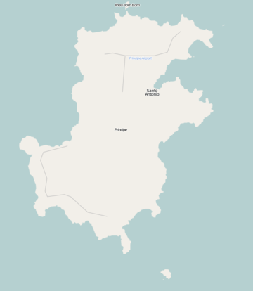 Santo António Location on Príncipe Island | |
| Coordinates: 1°38′12″N 7°25′04″E / 1.63667°N 7.41778°E | |
| Country |
|
| Province | Príncipe |
| District | Pagué |
| Elevation | 669 ft (204 m) |
| Population (2013) | |
| • Total | 1,357 |
| Time zone | UTC+0 (UTC) |
Santo António is the main settlement of Príncipe Island in São Tomé and Príncipe. It lies on the north east coast and the Palhota River. It serves as the capital of both Príncipe Province and Pagué District and has an estimated population of 1,200 residents, about 15% of the island's population.
History
| Historical population | ||
|---|---|---|
| Year | Pop. | ±% |
| 1990 (June 23, Census) | 1,000 | — |
| 2000 (June 16, Census) | 1,010 | +1.0% |
| 2005 (January 1, Estimate) | 1,156 | +14.5% |
| 2013 (Estimate) | 1,357 | +17.4% |
Discovery and Conquest
The town was the first settlement founded on the island, founded in 1502. The village is named after Saint Anthony. From 1753 until 1852, it was the colonial capital of Portuguese São Tomé and Príncipe, and the diocese seat was located in town.
Along with the island and the archipelago, the town was occupied by the Dutch under the context of the Habsburg Philippine Dynasty from August to October 1598. Later the Dutch ruled again and controlled the slave trade from 1641 to 1644, they were later expelled by the Portuguese. The town was destroyed in 1719 by the English pirate Bartholomew Roberts, nicknamed "John Roberts" and "Black Bart" in revenge of the death of the captain Howell Davis.
About the Town
The town is known for its colonial architecture and for its churches, the largest of which is the main Roman Catholic church, built in 1947. The town is also known for the Auto das Floripes play, which is performed by the citizens.
Ponta da Mina, located 2–3 km northeast in the hamlet of Fortaleza de Santo António da Ponta da Mina (locally as Fortaleza), is famous for its old fortress built in 1695. 2km south of the tower is the island's portion of Obo Natural Park and its Biosphere Reserve.
Santo António has a collegiate (colegio), churches, beaches, a small port and a few squares (praças).The local currency is the dobra.
Climate
Being at the equator brings very uniform temperatures year round with mean highs of 28 degrees Celsius and mean lows of 21 degrees Celsius. Average precipitation is just below 2000mm a year with monsoons and widespread flooding occurring in October.
| Climate data for Santo Antonio | |||||||||||||
|---|---|---|---|---|---|---|---|---|---|---|---|---|---|
| Month | Jan | Feb | Mar | Apr | May | Jun | Jul | Aug | Sep | Oct | Nov | Dec | Year |
| Record high °C (°F) | 32.5 (90.5) |
32.6 (90.7) |
33.4 (92.1) |
32.8 (91) |
32.0 (89.6) |
31.7 (89.1) |
30.3 (86.5) |
30.8 (87.4) |
30.3 (86.5) |
30.8 (87.4) |
31.8 (89.2) |
31.6 (88.9) |
33.4 (92.1) |
| Average high °C (°F) | 29.0 (84.2) |
29.6 (85.3) |
29.6 (85.3) |
29.4 (84.9) |
28.8 (83.8) |
27.6 (81.7) |
26.8 (80.2) |
27.1 (80.8) |
27.4 (81.3) |
27.5 (81.5) |
28.2 (82.8) |
28.6 (83.5) |
28.3 (82.9) |
| Daily mean °C (°F) | 25.5 (77.9) |
24.8 (76.6) |
25.8 (78.4) |
25.8 (78.4) |
25.4 (77.7) |
24.2 (75.6) |
23.5 (74.3) |
23.8 (74.8) |
24.3 (75.7) |
24.4 (75.9) |
24.8 (76.6) |
25.2 (77.4) |
24.8 (76.6) |
| Average low °C (°F) | 22.0 (71.6) |
20.0 (68) |
22.0 (71.6) |
22.1 (71.8) |
21.9 (71.4) |
20.7 (69.3) |
20.2 (68.4) |
20.4 (68.7) |
21.2 (70.2) |
21.4 (70.5) |
21.4 (70.5) |
21.8 (71.2) |
21.2 (70.2) |
| Record low °C (°F) | 19.4 (66.9) |
19.6 (67.3) |
20.0 (68) |
19.7 (67.5) |
19.7 (67.5) |
16.7 (62.1) |
15.6 (60.1) |
15.9 (60.6) |
18.7 (65.7) |
19.6 (67.3) |
19.5 (67.1) |
19.6 (67.3) |
15.6 (60.1) |
| Average precipitation mm (inches) | 113 (4.45) |
105 (4.13) |
186 (7.32) |
233 (9.17) |
229 (9.02) |
89 (3.5) |
21 (0.83) |
36 (1.42) |
146 (5.75) |
398 (15.67) |
174 (6.85) |
142 (5.59) |
1,872 (73.7) |
| Average precipitation days (≥ 0.1 mm) | 14 | 11 | 16 | 18 | 18 | 7 | 14 | 12 | 21 | 25 | 18 | 14 | 188 |
| Average relative humidity (%) | 88 | 86 | 86 | 87 | 88 | 83 | 83 | 83 | 86 | 89 | 88 | 87 | 86 |
| Source: Deutscher Wetterdienst[1] | |||||||||||||
Transportation
Santo António is linked with remote unpaved roads that connect the north part of the island to the south part of the island.
Príncipe Airport offers flights to São Tomé International Airport five times weekly on Africa's Connection STP.[2]
Sports
The town has the only sports facility on the island, Estádio Regional 13 de Julho. The facility is home to the football clubs Sporting Clube do Príncipe and GD Os Operários.
International Relations
Santo António is twinned with:
References
- ↑ "Klimatafel von Santo Antonio / Insel Principe / Sao Tomé und Principe" (PDF). Baseline climate means (1961-1990) from stations all over the world (in German). Deutscher Wetterdienst. Retrieved February 6, 2016.
- ↑ STP Airways Website
Autonomous Region of Príncipe/Pagué District | ||
|---|---|---|
| Communities |
|  |
| Geographical features | ||
| Buildings | ||
| Football | ||
| District capitals | |
|---|---|
São Tomé is also the national capital, Santo António is also the capital of the autonomous region of Príncipe | |