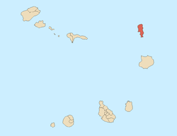
Sal, Cape Verde (municipality)
| Sal | ||
|---|---|---|
| Municipality | ||
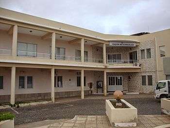 Municipal hall of Sal | ||
| ||
 | ||
| Coordinates: 16°44′N 22°56′W / 16.73°N 22.93°WCoordinates: 16°44′N 22°56′W / 16.73°N 22.93°W | ||
| Country | Cape Verde | |
| Island | Sal | |
| Area | ||
| • Total | 219.8 km2 (84.9 sq mi) | |
| Population (2010)[1] | ||
| • Total | 25,779 | |
| • Density | 120/km2 (300/sq mi) | |
| Website |
www | |
Sal is a concelho (municipality) of Cape Verde. It covers the whole island of Sal. Its seat is the city Espargos. The municipality was created in 1935, when it was separated from the Municipality of Boa Vista.[2] The municipal seat was originally at Santa Maria, but Espargos became the municipal seat in the 1970s.
Subdivisions
The municipality consists of one freguesia (civil parish), Nossa Senhora das Dores, which also covers the whole island. The freguesia is subdivided into the following settlements:
- Espargos (city)[3]
- Murdeira
- Palmeira (town)[3]
- Pedra de Lume
- Santa Maria (city)[3]
- Terra Boa
Politics
Since 2016, the Movement for Democracy (MpD) is the ruling party of the municipality. The results of the latest elections, in 2016:[4]
| Party | Municipal Council | Municipal Assembly | ||
|---|---|---|---|---|
| Votes% | Seats | Votes% | Seats | |
| MpD | 50.88 | 7 | 50.18 | 9 |
| PAICV | 43.58 | 0 | 41.14 | 7 |
| UCID | 2.82 | 0 | 5.83 | 1 |
| PSD | 0.34 | 0 | 0.38 | 0 |
References
- ↑ "2010 Census results". Instituto Nacional de Estatística Cabo Verde (in Portuguese). 24 November 2016.
- ↑ Direito da Terra, Compêndio de Legislação, p. 272
- 1 2 3 Cabo Verde, Statistical Yearbook 2015, Instituto Nacional de Estatística, p. 32-33
- ↑ Official results local elections 2016, Boletim Oficial I Série, Número 53, 23 September 2016
External links
The island of Sal, Cape Verde | ||
|---|---|---|
| Settlements | | |
| Mountains and hills | ||
| Points and promontories | ||
| Lighthouses | ||
| Other geographical features | ||
| Other topics | ||
This article is issued from
Wikipedia.
The text is licensed under Creative Commons - Attribution - Sharealike.
Additional terms may apply for the media files.